March 2016 archive

Protected: Client Video Discussion On The Heavy Rain Situation…

This content is password protected. To view it please enter your password below: Password:

You must be logged in to view this content. Click Here to become a member of IndyWX.com for full access.  Already a member of IndyWx.com All-Access?  Log-in here.

Permanent link to this article: https://indywx.com/2016/03/04/client-video-discussion-on-the-heavy-rain-situation/

Warm, But Wet Pattern Setting Up…

Screen Shot 2016-03-04 at 10.25.28 AM

Interested in more in-depth long range forecast discussions, video updates, ag. forecasts, and seasonal outlooks? E-mail bill@indywx.com for more information.

Permanent link to this article: https://indywx.com/2016/03/04/warm-but-wet-pattern-setting-up/

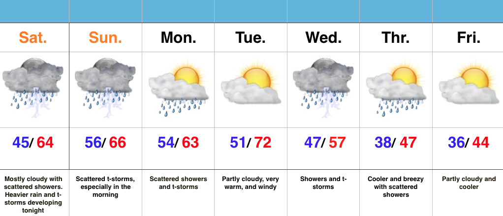
Next Week: Much Warmer, But Increasingly Wet…

As we begin to transition from winter to spring this weekend, it’s not only the impressive early season warmth that has our attention next week, but also a developing wet pattern.

NextWeekA combination of ingredients will result in a rather prolonged moist southwesterly air flow, with a Gulf of Mexico connection.  The end result is a wet pattern developing, especially come mid week.

1So while you get ready to enjoy the warmer than normal spring feel, it may also be wise to have the rain gear handy.

Interested in more in-depth long range forecast discussions, video updates, ag. forecasts, and seasonal outlooks? E-mail bill@indywx.com for more information.

Permanent link to this article: https://indywx.com/2016/03/03/next-week-much-warmer-but-increasingly-wet/

Snow Transitions To Rain…

Screen Shot 2016-03-03 at 7.11.27 AM

Highlights:

  • Snow changes to rain
  • Dry close to the work week
  • Warm, but wet pattern develops next week

Snow Transitions To Rain…Snow spread over central IN during the overnight and most neighborhoods accumulated between 1″-2″.  Warm air advection will result in snow transitioning to rain from south to north as we progress through the late morning hours.  All in all, it’ll be a raw Thursday.

Weak high pressure will build in and result in dry conditions Friday with sunshine returning.

A fast moving system will clip the region Saturday with a sprinkle or flurry possible, but this doesn’t appear to be a big deal in the least.

The bigger story?  The developing unseasonably warm period developing next week, but we caution this will also be a wet period as a prolonged SW flow transports moisture-rich Gulf of Mexico air into the region.  Heavy rain totals will be a good bet.

Permanent link to this article: https://indywx.com/2016/03/03/snow-transitions-to-rain/

Protected: Client Long Range Video And Snow Discussion…

This content is password protected. To view it please enter your password below: Password:

You must be logged in to view this content. Click Here to become a member of IndyWX.com for full access.  Already a member of IndyWx.com All-Access?  Log-in here.

Permanent link to this article: https://indywx.com/2016/03/02/client-long-range-video-and-snow-discussion/

Slushy Snow Late Tonight For Some…

Screen Shot 2016-03-02 at 7.32.36 AMHighlights:

  • Cold, dry midweek
  • Snow changes to rain for central IN Thursday morning
  • Much warmer times coming

Slushy Snow Late Tonight For Some…It’s a much colder feel out the door this morning!  You’ll want the heavier coat.  The good news? Dry conditions today, including lots of sunshine.

Our next fast moving storm system will spread snow into central IN during the overnight (after midnight for most) and accumulate for some (snowfall forecast below).  For the city, itself, look for a slushy coating to 1″.  Further north, a band of 1″-3″ is expected before the transition to rain mid to late morning.  Northern IN will be the “winner” with this system, including a 3″-5″ band.  All precipitation will be to our east by Thursday evening.

A dry close to the work week is expected before another fast moving storm system deliver a sprinkle Saturday, but this just doesn’t look to be a big deal at the moment.  We’ll keep an eye on things.

We turn much warmer early next week, but clouds and showers may keep us from being as warm as we could’ve been otherwise.  Better rain and storm chances arrive late Tuesday.  A stiff southwest wind will be with us early next week.

Thursday3:3:16For more in-depth and frequent video discussions and long-range forecasts, e-mail bill@indywx.com for details on our consulting options.

Permanent link to this article: https://indywx.com/2016/03/02/slushy-snow-late-tonight-for-some/

Protected: Client Snow Discussion: Thursday

This content is password protected. To view it please enter your password below: Password:

You must be logged in to view this content. Click Here to become a member of IndyWX.com for full access.  Already a member of IndyWx.com All-Access?  Log-in here.

Permanent link to this article: https://indywx.com/2016/03/02/client-snow-discussion-thursday/

Quick Tuesday Evening Video Brief…

For more in-depth and frequent video discussions and long-range forecasts, e-mail bill@indywx.com for details on our consulting options.

You must be logged in to view this content. Click Here to become a member of IndyWX.com for full access.  Already a member of IndyWx.com All-Access?  Log-in here.

Permanent link to this article: https://indywx.com/2016/03/01/quick-tuesday-evening-video-brief/

Protected: Client Long Range And Thursday Snowfall Forecast…

This content is password protected. To view it please enter your password below: Password:

You must be logged in to view this content. Click Here to become a member of IndyWX.com for full access.  Already a member of IndyWx.com All-Access?  Log-in here.

Permanent link to this article: https://indywx.com/2016/03/01/client-long-range-and-thursday-snowfall-forecast/

IndyWx.com Welcomes Meteorologist Joe Reedy

03.01.16
For immediate release:

IndyWx.com is excited to announce the addition of meteorologist Joe Reedy to the team!  Joe will help handle forecasting duties on the site, including private client updates across the region.

Screen Shot 2016-03-01 at 5.52.12 PMJoe Reedy joined IndyWx.com in February of 2016.  Joe became fascinated with the weather at a young age- during the 1993 blizzard to be exact. Joe most recently served as the Chief Meteorologist for ABC 19 News in Kingsport, TN from 2012-2016.

Mr. Reedy is a graduate of Lyndon State College, (L.S.C.). Lyndon State is located in the Northeast Kingdom of Vermont and has been named the number one college for both broadcasting and meteorology students.  During Joe’s career at Lyndon State, he was an active member of the Lyndon State College AMS & NWA and served as the 06′-07′ Community Outreach Officer, which is responsible for organizing the largest student-run conference, the annual Northeastern Storm Conference.  Joe is honored to be back on the ‘original weather team’ and to give you a dependable forecast with “Indy’s Behind The Scenes Weather.”

IndyWx.com LLC posts free weather content on their homepage, focused on Indiana.  Additionally, IndyWx provides consulting and long range, seasonal forecasts to clients across the Ohio Valley and southern Appalachian region.  For more information on their consulting services, please e-mail bill@indywx.com for further details.

Permanent link to this article: https://indywx.com/2016/03/01/indywx-com-welcomes-meteorologist-joe-reedy/

IndyWx.com