Busy Pattern; Cool Blast Late Week…

Screen Shot 2016-05-09 at 2.55.53 PMHighlights:

  • Scattered showers and storms continue
  • Big cool blast looms
  • Renewed wet stretch next week?

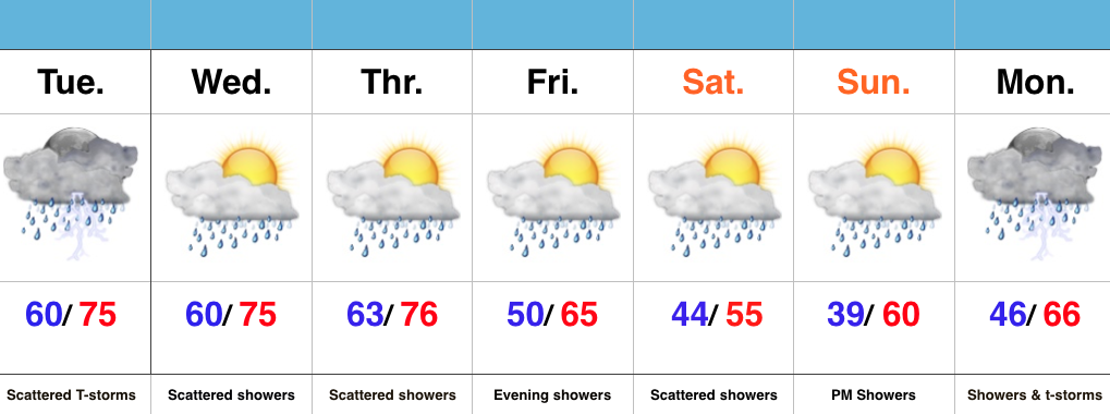
Active Times…It’s not so much the amount of rain that we’re seeing, but the overall duration of the gloomy, wet times.  A stalled frontal boundary will remain draped over central parts of the state over the next 72 hours and this will help create periods of showers and thunderstorms through mid week.  Localized heavy rain is possible, but the heavy rain totals certainly won’t fall in a “uniform” fashion.  Tuesday afternoon and evening appears to still offer up a strong to severe thunderstorm chance.

Eventually a cold front will sweep the state Thursday and help usher in a much cooler air mass to wrap up the work week.  An upper level disturbance will follow and provide a period of showers and light rain Friday evening.  A spotty shower may continue Saturday with the much cooler air, but more widespread rains look to build in Sunday into Monday.  There remains a great deal of disagreement on the forecast late in the weekend into early next week, so stay tuned as we fine tune things in the days ahead.

It’s a busy pattern, indeed, friends…
Monday Morning Video Update: Strong Storms Tuesday; Much Colder End To The Week…

An unsettled week ahead will feature periods of more widespread rain and stronger storms at times between now and Wednesday.  We’re focused on Tuesday for the potential of strong to…

You must be logged in to view this content. Click Here to become a member of IndyWX.com for full access.  Already a member of IndyWx.com All-Access?  Log-in here.

Unsettled Week; Another Cool Blast Looms…

Screen Shot 2016-05-08 at 8.54.42 AMHighlights:

  • Cool Mother’s Day
  • Periods Of Rain And Storms
  • Another Cool Blast Looms

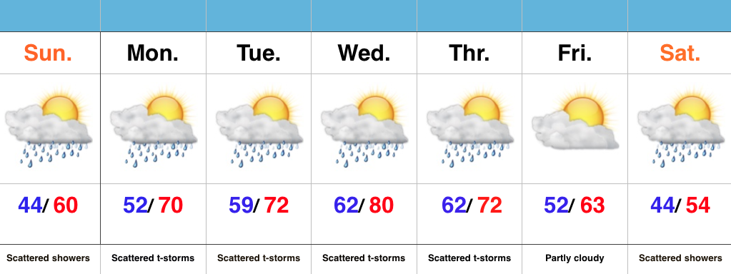
Have The Rain Gear Handy; Don’t Put Away Those Coats…A “wavy” frontal boundary will remain in our general vicinity over the next few days and be responsible for offering up periods of showers and eventually thunderstorms (as warmer, more humid air surges in Monday).  It’s a “rinse and repeat” pattern this week as daily shower and thunderstorm chances continue.  Models are in agreement on rain amounts of 1.5″-2″ between now and Thursday night, with locally higher amounts.

Eventually, a cold front will sweep through the state Thursday evening and set up a MUCH cooler than normal weekend.  Instability-driven showers are possible Saturday, but the big story will be the unseasonably chilly air over the weekend into early next week.