
You must be logged in to view this content. Click Here to become a member of IndyWX.com for full access. Already a member of IndyWx.com All-Access? Log-in here.
Permanent link to this article: https://indywx.com/video-active-week-of-weather-ahead/
Mar 04
Never Over ‘Till It’s Over…
The period outlined is March 6th through March 20th. As the block continues to mature, we think this timeframe will produce at least one (if not a couple) opportunities for “meaningful” accumulating wintry precipitation across the Ohio Valley and features below normal temperatures.

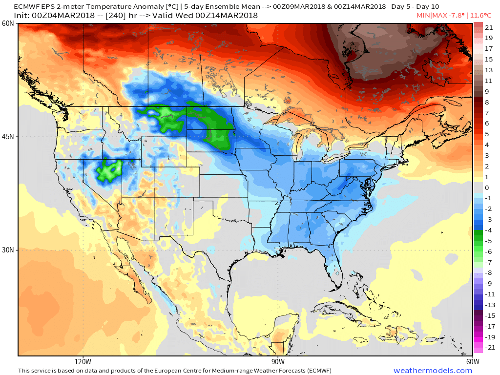 Model data continues to show this idea has merit and now we’ll have to handle the individual storms as they come. As we’d expect late in the winter, challenges abound, but this is a pattern that has potential. Can we turn potential into reality? That’s the question that will be answered over the next couple weeks.
During the upcoming week, snow showers will fly Wednesday, but this doesn’t appear to be a big deal. With vigorous upper level energy tracking across the region, it should be sufficient enough to generate scattered snow showers and potentially a couple more intense squalls (especially across eastern portions of the state) Wednesday.
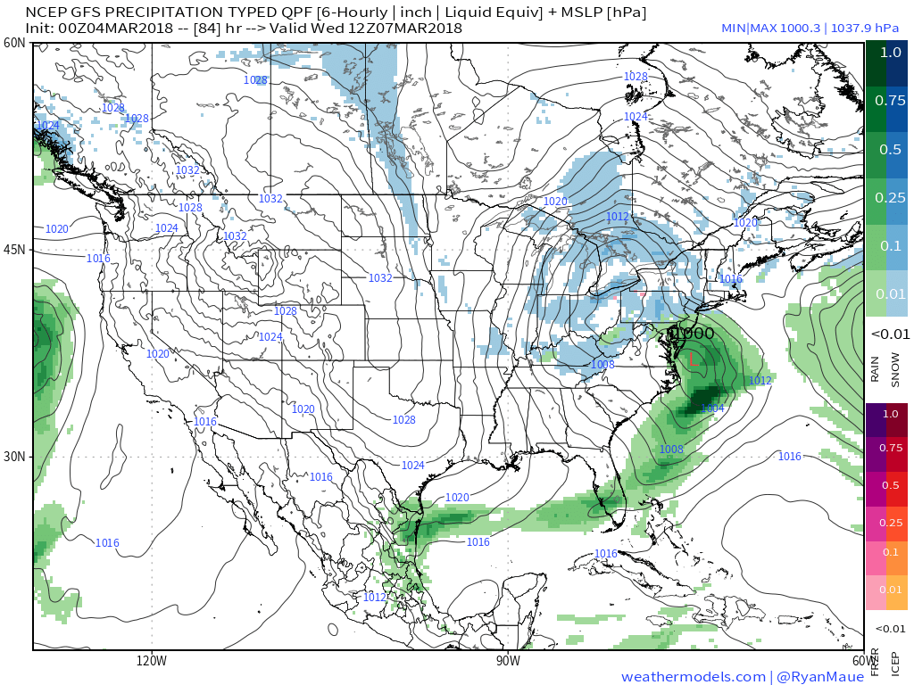 The next item on the agenda will arrive Friday afternoon into Friday night. It, too, should spread snow across a portion of the Ohio Valley. With this being in the Day 6 time period, expect fine tuning as we move through the upcoming week.
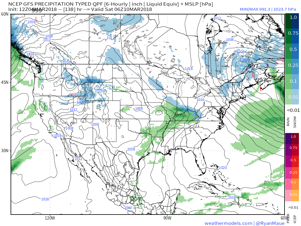 Finally, a third system will impact the area about this time next week, and it’s this system that appears to be the most significant of the group. Far too early to get detailed, but it certainly warrants our attention.
 The overall pattern we’ll “enjoy” over the next couple of weeks is one that’s been lacking for the better part of the past few winters. With blocking in place, storm systems trying to lift into the Great Lakes will be “forced” south and result in an active time of things around these parts- including the east coast, as well, over the better part of the upcoming 10-15 days.
Understanding that storms this time of year have to get several things to “line up” just right to result in an impactful event, it’s far too early to signal winter’s over…
Permanent link to this article: https://indywx.com/never-over-till-its-over/
Mar 03
VIDEO: Sunshine Dominates The Weekend; Active Couple Weeks Ahead…
You must be logged in to view this content. Click Here to become a member of IndyWX.com for full access. Already a member of IndyWx.com All-Access? Log-in here.
Permanent link to this article: https://indywx.com/video-sunshine-dominates-the-weekend-active-couple-weeks-ahead/
Mar 02
Sun-filled Weekend; Colder Next Week…
High pressure is building in and will supply a gorgeous early-March weekend. Look for plentiful sunshine. Gusty winds this morning will begin to diminish as we rumble into the weekend. While a bit chilly today, that increasingly powerful early-March sun angle will have things feeling mighty nice over the weekend. We suggest finding a patio and enjoying!
 Our next storm system will arrive Monday. Clouds will increase overnight and showers (mostly light) will arrive on the scene during the day. Rainfall amounts aren’t expected to be significant this go around (in general, 0.25″ to 0.40″ for most). Winds will turn strong and gusty during the day Monday, continuing Tuesday and Wednesday.
 Colder air will get pulled into the Ohio Valley Tuesday evening and as upper level energy moves overhead, mixed rain and snow showers will develop Tuesday night through Thursday morning.

 By next Thursday morning, widespread lows in the 20s can be expected.
Permanent link to this article: https://indywx.com/sun-filled-weekend-colder-next-week/
Mar 01
VIDEO: March Roaring In Like A Lion…
You must be logged in to view this content. Click Here to become a member of IndyWX.com for full access. Already a member of IndyWx.com All-Access? Log-in here.
Permanent link to this article: https://indywx.com/video-march-roaring-in-like-a-lion/
