
You must be logged in to view this content. Click Here to become a member of IndyWX.com for full access. Already a member of IndyWx.com All-Access? Log-in here.
Category: Winter thoughts…
Permanent link to this article: https://indywx.com/video-early-december-warmth-wont-last/
Nov 16
Digging Deeper As Winter Nears…
Thanksgiving is only a week away (where on earth does time go?!) and more and more folks are asking what we think winter will hold for central Indiana. In case you missed it earlier this fall, here’s our official Winter Outlook.
We’re continuing to dig in and monitor new data that’s streaming into the office, as well as ocean profiles. With that said, we wanted to share some of our findings with you this morning with respect to how various ocean regions can impact our weather this winter.
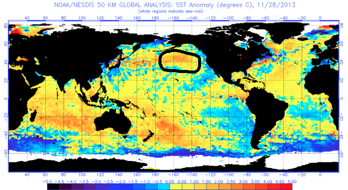
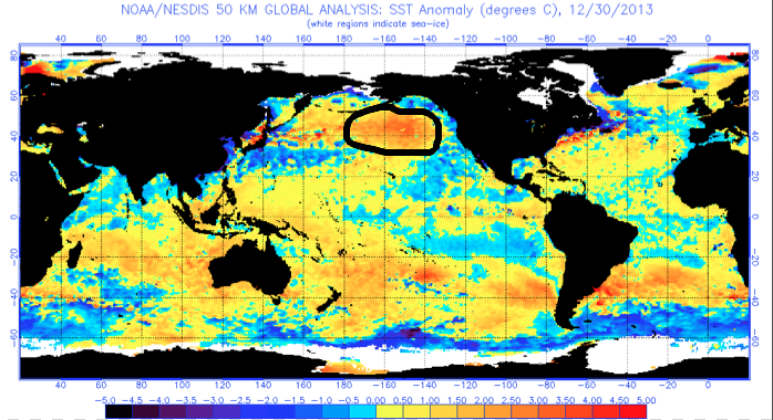
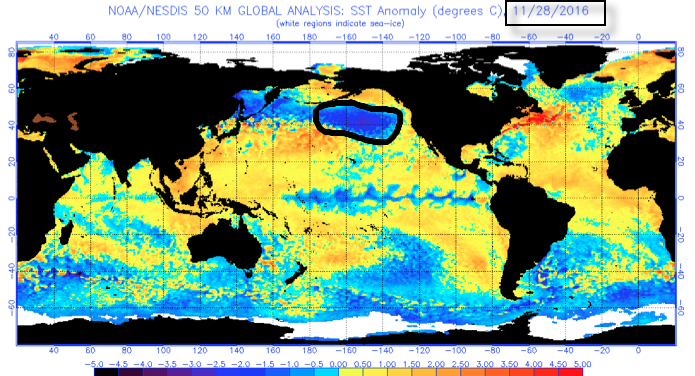
We’re noticing significant changes, particularly in the north Pacific, with the famous “warm blob” emerging (image 1). This is a big factor that aided in persistent cold; wintry weather during the ’13-’14 winter (images 2-3). Notice the difference from last year, too (image 4). This isn’t a full blown cold PDO (Pacific Decadal Oscillation) yet, but trending in that direction and “ups the ante” for cold, wintry conditions, locally this year.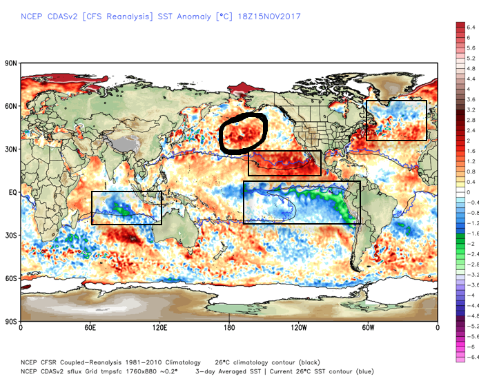
 What makes seasonal forecasting so challenging (and fun :-)) are the multiple features that can impact a forecast. We’ve talked about the importance of ENSO (various types of Nino and Nina events) in past updates, as well as low solar and QBO. All of these moving parts and pieces are coming together in a manner that seems to be favoring more of a cold, wintry regime, locally, this year. Is that us saying another blockbuster 2013-2014 winter awaits? Absolutely not (there are other differences noted above with the SST configuration). However, it is suggesting that this winter will be absolutely nothing like the past couple…
Might want to think about getting the snow blower tuned up!
More later today on the short-term. Make it a great Thursday!
Permanent link to this article: https://indywx.com/digging-deeper-as-winter-nears/
Sep 29
A Note And Some Perspective On Next Week’s New Warm Surge…
After a cool, fall-like, weekend, we still expect a new surge of summer-like air to return next week as a strong (and expansive) ridge of high pressure “balloons” over the eastern half of the nation.
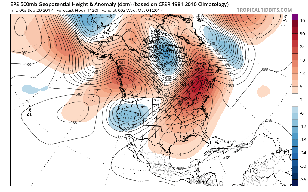 This will be enough to send temperatures into the 85° to 90° range by the early to middle of next week. To shed some perspective on that, our averages for early October include low temperatures in the upper 40s and highs in the upper 60s. For at least a couple of days next week, overnight lows will be much closer to where our afternoon highs should be this time of year.
There are differences on how modeling handles the evolution of things once past midweek. The European model has been jumping on a potential wet weather maker and much cooler trend in the medium term (late next week), but the GFS is having none of that- keeping us dry and hot. We’ll keep a close eye on things over the next couple of days and have a fresh 7-day soon!
Finally, we’re receiving many questions that are centered on whether or not the current overall warm pattern is an indication of what we can expect this winter. The simple and short answer to that question is an emphatic “no.” Transitional seasons are fickle, regardless of ENSO state. Throw in an emerging Nina and all sorts of additional “fun and games” ensue. With that said, there’s no direct correlation specifically between warm (or cold) patterns this time of year and the winter ahead. In fact, there’s been many instances where unseasonably warm Octobers give way to cold winters, and vice-versa.
More later! Make it a great Friday!
Permanent link to this article: https://indywx.com/a-note-and-some-perspective-on-next-weeks-new-warm-surge/
Aug 13
The Week Opens Quiet Before More Unsettled Times Return…
High pressure will remain in control of our weather pattern through the early portions of the new week. This will supply continued dry conditions, along with plentiful sunshine. Humidity values will remain comfortable as we open the work week before turning increasingly muggy as midweek nears.
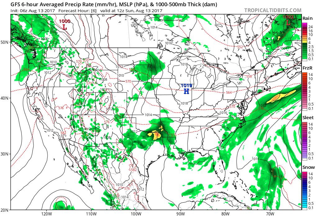
High pressure will keep us dry through early week.
As high pressure moves off to the east, a southwesterly air flow will help moisture return to the state by mid and late week. As a cold front enters the picture, overall coverage of showers and thunderstorms will increase and become scattered to numerous. We’re not expecting any sort of all-day rains, but chances of getting wet from time to time will go up Wednesday through Friday.
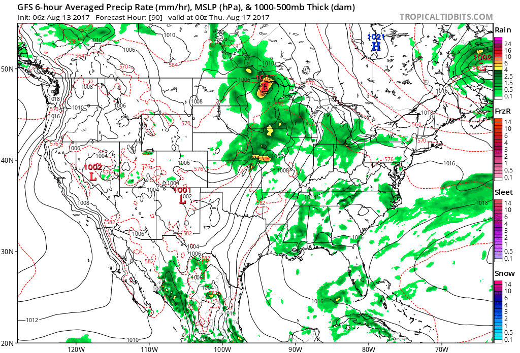
Thunderstorm coverage increases mid and late week.
Rainfall totals should fall in the 0.50″ to 1.00″ range for most, but there will be a few folks who pick up locally heavier amounts the second half of the week.
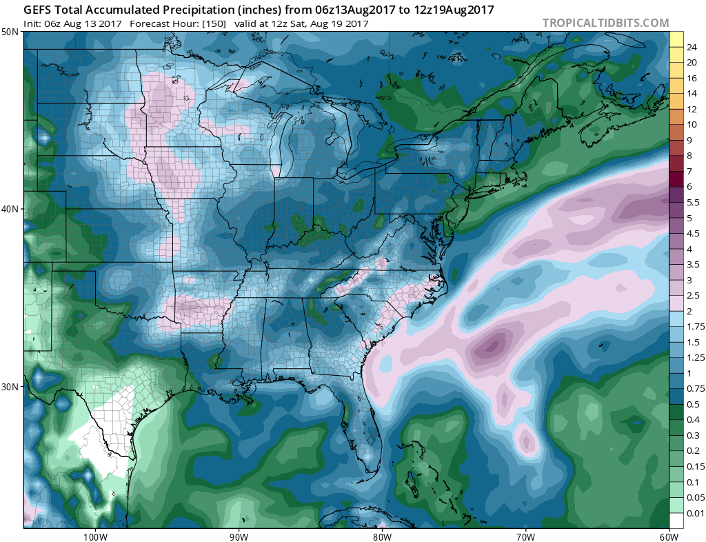 As of now, we think the cold front will pass Friday evening and set-up another pleasant weekend with seasonable temperatures. The stretch of gorgeous August weekends’ appears to roll along.
What else we’re working on: With us about to flip the page to the second half of August, thoughts continue to shift to the upcoming meteorological fall and winter seasons ahead. Early data paints an “intriguing” look, complete with high latitude blocking and neutral ENSO look. Winter enthusiasts should like the look overall as this will have an impact on the prospects of cold getting going earlier than recent years past. Much more on fall and winter in the weeks ahead… The other big item of interest has to do with the tropics. A new disturbance will traverse the MDR (Main Development Region) this week and given the overall upper level pattern over the CONUS, we’ll have to keep an eye on the East Coast Weeks 2-3.
Permanent link to this article: https://indywx.com/the-week-opens-quiet-before-more-unsettled-times-return/
Jan 15
Sunday Afternoon Rambles…
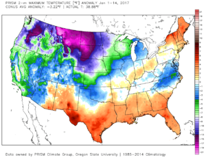
1.) January, month-to-date, is running slightly above normal at IND (+1.2 F) and nearly 1″ above normal in the precipitation department. Keeping true to the winter, overall, greatest cold departures are centered over the northern Plains and northern Rockies.
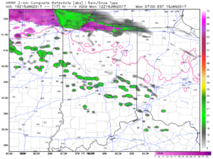
 2.) Showers will creep north overnight into Monday morning, but shouldn’t amount to much. They will be scattered in nature across central Indiana.
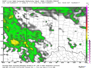
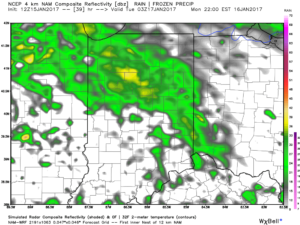
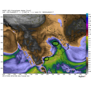
 3.) More widespread rain and embedded thunder will develop Monday night into Tuesday morning. This should amount of widespread half inch to one inch totals across the viewing area.
 4.) A moist southwest flow will help push a warmer regime northward for the second half of the week. Though warm, we’ll also have to deal with periods of rain as disturbances track northeast. We circle Friday and Sunday as the wettest days and remain optimistic Saturday will feature dry and unseasonably warm conditions (lower-middle 60s). Between the rainy days Friday and Sunday, additional rainfall totals of 1″-2″ seem like a good bet.
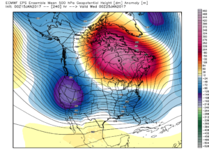
 5.) The evolution of the pattern just beyond the 7-day period we’ll begin to take on an increasingly wintry look and we remain confident on a flip back to wintry conditions as we roll through the last week of the month. We’ll have to keep a close eye on a storm system in the 8-10 day period. It’s obviously way too early to discuss specifics, but this will be the time the pattern is beginning to turn back towards a wintry regime…
Permanent link to this article: https://indywx.com/sunday-afternoon-rambles-2/