10 Day AG-Weather Outlook
Issued: 02.07.16
Forecast period: 02.07.16 – 02.17.16
Focal Items:
- Busy winter pattern from the Plains east
- Dry and warm across the West
- Potential widespread winter storm threat days 7-10 from the Plains into the East
Summary: Changes are underway at the beginning of the period with a positive PNA pattern in place. This will support a drier and warmer than normal time of things across the west with a shift towards much colder than normal temperatures across the eastern half of the country. Early in the period, we’re tracking a coastal storm that will deliver blizzard conditions to the Cape Monday and a big upper low over the Great Lakes and Ohio Valley. This will provide a prolonged snow shower event across the areas mentioned above. Toward the end of the period, we’ll have to remain focused over the southern/ central Plains for the potential of a developing winter storm that would then advance into the Ohio Valley and eventually Mid Atlantic.
Sensible Impacts: Strong ridging across the West will keep things drier and warmer than normal, with the action across the eastern half of the nation.
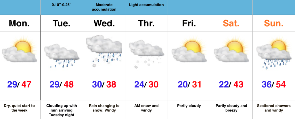
In addition to snow, wind, and near blizzard conditions that will impact the Cape to open the work week, blizzard conditions will also impact the northern Plains as an upper trough drops south. The same trough and associated upper level energy will deliver snow showers and embedded blinding snow squalls south into the Ohio Valley and southern Appalachians through mid week, as well.
A very active northwest flow will send light to moderate snow makers southeast out of the N. Plains into the Ohio Valley through the upcoming work week. Overall, most snowfall accumulations will remain light, with the exception of Snow Belt areas.
A significant winter storm appears to be brewing next weekend and could impact a large portion of the Plains, Ohio Valley, and Mid Atlantic towards the end of the period.
Temperature Anomalies: A very cold time of things is ahead for the forecast region through the period. In some cases, temperatures will fall to levels some 15-20 degrees below normal.
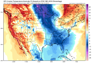
Temperature anomalies Tuesday. Source: Tropicaltidbits.com
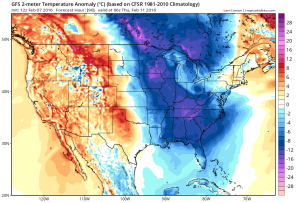
Temperature anomalies Wednesday. Source: Tropicaltidbits.com
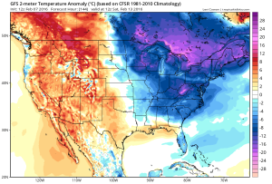
Temperature anomalies next weekend. Source: Tropicaltidbits.com
Precipitation: Snowfall will generally be light through the forecast region this week. Despite the light snowfall, very strong winds will likely lead to blizzard conditions in the open country, particularly across IA and MN early in the period. Heavier snow will be possible as the potential winter storm develops next weekend across the central Plains.

 Highlights:


