Category: Winter Storm

Long Duration Snow Shower Event; Hope You Like Winter…

Screen Shot 2016-02-07 at 2.17.06 PMHighlights:

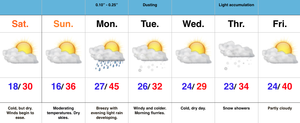
  • Long duration snow shower event
  • Heavier snow squalls possible Monday night-Tuesday morning
  • Another push of snow late week
  • Bigger winter storm potential at the end of the period

Long Duration Snow Shower Event…A cold front will move through the area late tonight and may be accompanied by a shower or sprinkle as it moves through the region.  Colder air will filter in behind the boundary after midnight and snow showers will begin to blossom Monday morning. This will be the beginning of a solid 48-60 hours of snow falling across most of central IN.  We think heavier snow bursts and embedded squalls are a good bet Monday night into Tuesday morning as the true arctic air begins to push into the area.  With so much upper level energy around, snow showers will continue into Wednesday.

As far as accumulation goes, we think the majority of central Indiana will accumulate 2″-3″ during the early week event, but this won’t be a uniform snow at all (there will be “haves” and “have nots”).  Locally, there will also be a few 4″ reports.

Though timing is a challenge in this fast, active northwest flow, we think we’ll be dry and cold Thursday before snow returns to close the work week as another disturbance and reinforcing arctic air move south.

Well below normal cold remains entrenched across the region for Valentine’s weekend, and we note wintry “fun and games” brewing to our west Saturday night into Sunday.  We’ll forecast a lowering and thickening cloud deck here Sunday with snow developing during the afternoon and evening. Early indications continue to suggest this could be a storm of “importance” around these parts…  Stay tuned.

Permanent link to this article: https://indywx.com/long-duration-snow-shower-event-hope-you-like-winter/

Friday Evening Video Update…

You must be logged in to view this content. Click Here to become a member of IndyWX.com for full access.  Already a member of IndyWx.com All-Access?  Log-in here.

Permanent link to this article: https://indywx.com/friday-evening-video-update-4/

10 Day Ag-Weather Outlook…

10 Day AG-Weather Outlook

Issued: 01.31.16

Forecast period: 02.01.16 – 02.10.16

Focal Items:

  • Plains blizzard Days 1-3
  • Severe threat from the Mid South to the Ohio Valley Tuesday
  • Impactful winter event developing late in the period

Summary:  The forecast period will begin with strong ridging across the eastern half of the CONUS, while a significant trough digs across the west. That trough will lift northeast through the middle of the upcoming work week before re-amplifying over the upcoming weekend into early week 2 across the Plains and Ohio Valley region.

Sensible Impacts:  A significant storm system will move off the Rockies and into the Plains Monday.  The surface low  will track northeast from SE CO Monday night into SW MI Tuesday night.  To the north and northwest of the surface low, heavy snow and blizzard conditions will impact areas from CO, KS, NE, IA, MN, and WI.  South and southeast of the surface low track, strong to severe thunderstorms will rumble through the lower MS Valley, TN Valley, and Ohio Valley Monday night into Tuesday night.  All modes of severe weather will be possible, including tornadoes.

We’ll need to keep a close eye on the potential of a clipper system diving SE across the N. Plains and upper Ohio Valley over the upcoming weekend, but the bigger event appears to be a developing winter storm threat centered on the end of the period (2/8-2/10 time period).  There are, obviously, a lot of details to sort through, but an impactful winter event is very possible across the Ohio Valley towards the end of the forecast period.

Temperature Anomalies:  The period will open much warmer than normal, but transition cold, and eventually colder than normal by the end of the period across the forecast region.

Screen Shot 2016-01-31 at 5.25.30 PM

Anomalous warmth will engulf the Ohio Valley to open the forecast period. Source: Penn State E-Wall

The pattern shifts colder than normal towards the end of the period across the Plains into the southeast. Source: Penn State E-Wall

The pattern shifts colder than normal towards the end of the period across the Plains into the southeast. Source: Penn State E-Wall

Precipitation:  A stripe of heavy snows (10″-15″) will fall from CO, NE, IA, southern MN, and WI with the initial early week storm.  .5″-1.5″ of rain will fall across the Southeast, TN, and OH Valley regions (locally heavier totals where strong storm train).  Overall, quieter times return mid and late week for the forecast region before the next potential strong storm develops late in the period.

For private weather consulting and more detailed ag-weather updates, please e-mail bill@indywx.com.

Permanent link to this article: https://indywx.com/10-day-ag-weather-outlook/

Dry Weekend; Clipper Snow Next Week?

Screen Shot 2016-01-23 at 10.13.29 AMHighlights:

  • Cold, but dry weekend
  • Weak system delivers showers/ flurries early week
  • Models disagree on clipper track

Cold, But Lots-O-Sunshine…A major winter storm is hammering areas still from the southern Appalachians into the Mid Atlantic and Northeast.  Light flurries fell across central IN Friday evening, but drier air quickly built into the region overnight and sets the stage for a cold, but sunny weekend.  Gusty NE winds that were felt Friday and overnight will also begin to diminish today.

Our next weather maker will blow into town Monday, but will be weak.  Showers will accompany the frontal passage Monday evening before snow flurries/ light snow showers fly in the cold air advection Tuesday morning.  All in all, this won’t be a big deal.

The next potential “trouble maker” awaits for the middle part of the week, but caution model data is all over the board on the eventual track of this clipper system.  We’ll lean more towards the Canadian solution at this juncture (model of choice with clippers) and forecast snow showers to build into central IN Thursday.  From this distance, model solutions range from snowy (light accumulation) to dry and mild.  We wouldn’t have it any other way this winter. 😉

Permanent link to this article: https://indywx.com/dry-weekend-clipper-snow-next-week/

Blizzard of 2016…

**A fresh 7-day will be posted here later this morning. The past few days we’ve been busy updating our friends across the beautiful east TN mountains on the Blizzard of…

You must be logged in to view this content. Click Here to become a member of IndyWX.com for full access.  Already a member of IndyWx.com All-Access?  Log-in here.

Permanent link to this article: https://indywx.com/blizzard-of-2016/