
You must be logged in to view this content. Click Here to become a member of IndyWX.com for full access. Already a member of IndyWx.com All-Access? Log-in here.
Category: Winter Storm
Permanent link to this article: https://indywx.com/heavy-snow-tonight-timing-out-part-2-monday-and-looking-closer-at-the-late-month-pattern/
Dec 15
Client Brief: Updated Snowfall Forecast; Conditions Go Downhill Quickly This Evening…
Type: Impactful Wintry Weather
What: Accumulating snow; mixed wintry precipitation
When: This evening and Monday afternoon – Tuesday morning
Temperatures: Lower to middle 30s, falling into the middle 20s Tuesday morning
Wind: East northeast 10 to 15 MPH, shifting to the northwest Monday night with gusts to 25 MPH
Blowing/ Drifting: Minimal
Pavement Impacts: Plowing and salting will be required.

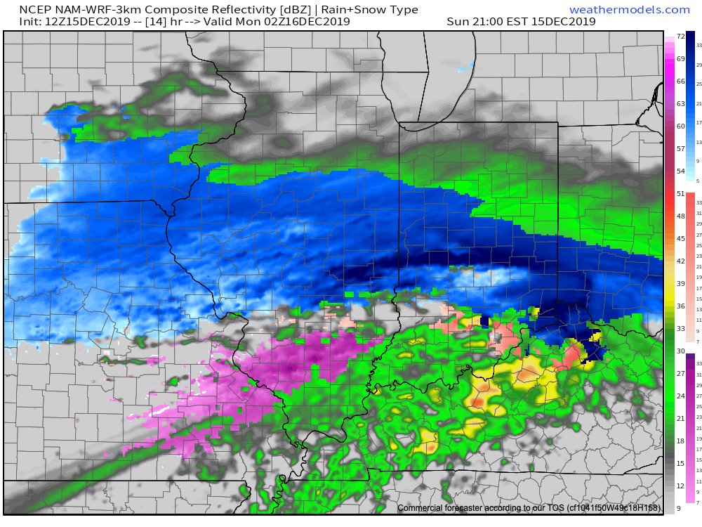
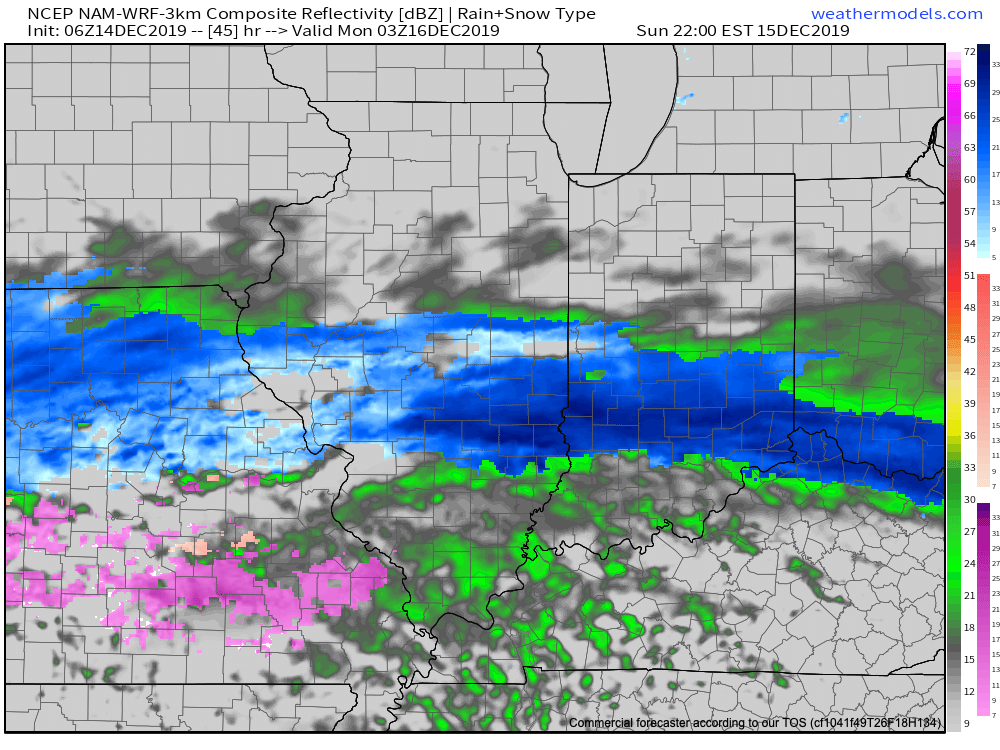
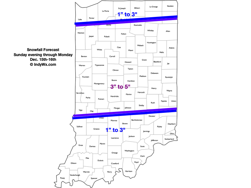
Right out of the gate, let’s talk accumulation: While we don’t need to make significant changes to the snowfall forecast, we did “tighten” the 3″ to 6″ band up a bit and scaled the 1″ to 3″ zones closer into central Indiana on both the north and south sides. This continues to be a central Indiana event- at least as far as heaviest snowfall totals go.
This event will still come in 2 waves, but it now appears as if the initial surge of moisture this evening and tonight will feature the heaviest snowfall rates. Snow will overspread the region this evening (arriving into Indianapolis, itself, between 6p and 7p) and come down heavily at times through the overnight hours. Part 1 will end before daybreak, but the damage will have been done by that point and the morning commute will be significantly impacted as central Indiana digs out from 3″ to 5″ of wet snow.
We’ll get a break through the bulk of the daytime Monday, but precipitation will once again overspread the region from southwest to northeast Monday evening, continuing into the predawn hours Tuesday. This will take the form of snow across central Indiana with a wintry mix and/ or a cold rain across southern and southeastern Indiana. An additional coating to 1″ of snow is possible with this 2nd wave of moisture.
Finally, winds will shift to the northwest and drive colder air into the state Monday night behind the departing storm. Everyone (including southeastern Indiana) will be below freezing Tuesday morning with additional travel impacts likely.
Confidence: High
Next Update: This evening
Permanent link to this article: https://indywx.com/client-brief-updated-snowfall-forecast-conditions-go-downhill-quickly-this-evening/
Dec 14
VIDEO: 2-Part Storm Sunday Evening-Tuesday Morning; Active Times Through The Holiday Season…
You must be logged in to view this content. Click Here to become a member of IndyWX.com for full access. Already a member of IndyWx.com All-Access? Log-in here.
Permanent link to this article: https://indywx.com/video-2-part-storm-sunday-evening-tuesday-morning-active-times-through-the-holiday-season/
Dec 14
Client Brief: Snow Storm Inbound Sunday Evening – Monday…
Type: Impactful Wintry Weather
What: Accumulating snow; mixed wintry precipitation
When: Sunday evening through Monday
Temperatures: Lower to middle 30s, falling into the lower to middle 20s Monday night
Wind: East 10 to 15 MPH, shifting to the north Monday night with gusts to 25 MPH
Blowing/ Drifting: Minimal
Pavement Impacts: Plowing and salting will be required.
Sunday will feature a thickening and lowering cloud deck through the afternoon hours and this foretells what’s to come by evening. An expanding area of snow will overspread southern Indiana early evening and push into central/ north-central Indiana by mid-to-late evening, continuing into Sunday night. This will be the 1st of 2 rounds of wintry precipitation that will likely result in “plowable” accumulations for a good chunk of central Indiana come Monday evening. There will likely be a “lull” in the wintry precipitation Monday morning, but we anticipate widespread wintry precipitation to return late morning through the afternoon and into the evening hours Monday. In and around Indianapolis and points north, this 2nd round of precipitation should also primarily take the form of snow, but we think southern Indiana will have a period of sleet and potentially a cold rain across far southern Indiana before transitioning back to snow before ending. Because of this, we think southern Indiana will fall into the 1″ to 3″ range for storm totals. Much colder air will pour into the state Monday evening as winds shift to the north/ northwest and gust up to 25 MPH. Snow will pull out of the state from west to east late Monday night. Due to the timing of this storm, big impacts are expected to the morning and evening rush hours Monday.
Confidence: High
Next Update: 2:30p Saturday
Permanent link to this article: https://indywx.com/client-brief-snow-storm-inbound-sunday-evening-monday/
Dec 13
Client Brief: Impactful Winter Weather Event Sunday Evening Through Monday…
Type: Impactful Winter Weather
What: Accumulating snow; mixed wintry precipitation
When: Sunday evening through Monday
Temperatures: Lower to middle 30s
Wind: East 10 to 15 MPH, shifting to the north Monday night with gusts to 25 MPH
Blowing/ Drifting: Minimal
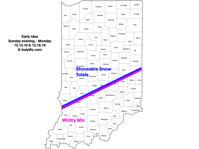
We continue to closely monitor the potential of an impactful winter weather maker Sunday evening through Monday. Initially, we think “overrunning” precipitation will overspread central Indiana Sunday afternoon and evening. This should fall in the form of snow for most. As the surface low draws closer, precipitation will increase in intensity Sunday night into the day Monday. The all-important track of the surface low appears to take a path from western Arkansas Sunday night, along the Ohio River Monday morning and into western Pennsylvania by Monday night. This is a favorable track for accumulating snow across portions of the state. The map above features our “ridiculously” early idea on best chances where the heavier snowfall will occur (shoveable totals seem like a good bet for places in and around Indianapolis and points north). Downstate, enough warmer air should get pulled into the system for a time Sunday night into Monday morning that a wintry mix of precipitation (sleet, snow, and rain) is expected to cut down snowfall totals. As the storm pulls up to our northeast, gusty northerly winds will develop with lingering snow showers in Monday night, along with colder conditions.
We’ll have an updated video post later this evening and will keep close eyes on data not only today, but straight through the weekend.
Confidence: Medium-High
Next Update: This evening (Video)
Permanent link to this article: https://indywx.com/client-brief-impactful-winter-weather-event-sunday-evening-through-monday/