VIDEO: Unseasonably warm pattern to open November…
You must be logged in to view this content. Click Here to become a member of IndyWX.com for full access. Already a member of IndyWx.com All-Access? Log-in here.
You must be logged in to view this content. Click Here to become a member of IndyWX.com for full access. Already a member of IndyWx.com All-Access? Log-in here.
 Highlights:
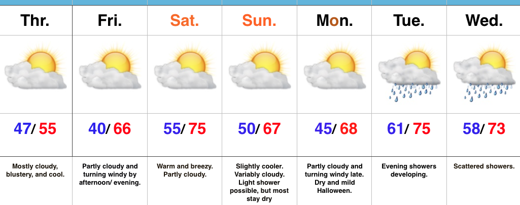
Chilly Today, But Warmer Times Loom…A cold front swept through central IN earlier this morning. Since we’re on the NW side of the front now, a cooler air mass is filtering in as we type this. Today will be blustery and chilly with considerable cloudiness. That said, the chilly air will only hang around for 24 hours, as we begin to moderate Friday afternoon. SW winds will blow Friday PM and help give a chilly start to the day a rather significant boost into the upper 60s for a high. Saturday will out-do that as we zoom into the middle 70s.
A weak front will slip through here Sunday and cool us off a few degrees. While a light shower is possible as the front moves through, we think most stay dry.
We quickly return to the warm regime early next week. At this time, Halloween looks mild and dry for those trick-or-treaters out there.
Looking further down the road, significant changes loom by mid and late November. Those changes include the following words: cold and wintry…
Upcoming 7-day Precipitation Forecast:
You must be logged in to view this content. Click Here to become a member of IndyWX.com for full access. Already a member of IndyWx.com All-Access? Log-in here.
 Highlights:
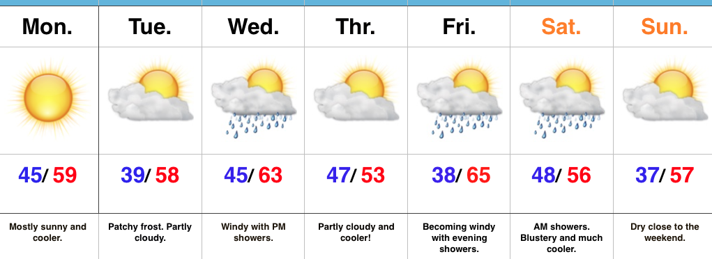
Fall Feel To Open The Week…A dry frontal boundary will pass through central IN late tonight. Our winds will shift to the NW after midnight and help drive in a cooler air mass to open up the new work week. Despite lots of sunshine, temperatures will be running below average to open the work week.
A fast-moving storm system will scoot through the lower Great Lakes region Wednesday. This will help serve to strengthen our winds (SW direction) along with create a chance of scattered showers Wednesday evening. Another pop of unseasonably cool air will blow into town Thursday.
Yet another storm system will press through the region as we get set to head into the weekend. Rainfall totals don’t look particularly impressive, but we’ll lean more towards the Friday night/ Saturday morning storm system as being the better rain-maker of the (2) systems this week. Cooler air will flow in behind the storm system for the weekend.
Upcoming 7-Day Precipitation Forecast:
You must be logged in to view this content. Click Here to become a member of IndyWX.com for full access. Already a member of IndyWx.com All-Access? Log-in here.