Weekend Moderation…

Highlights:

  • Northern IN snow
  • Weekend moderation
  • Showers early next week

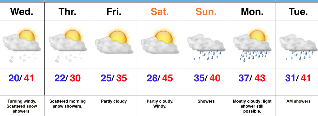
Majority Of Snow To Our North, Northeast…A fast moving northwest flow will continue to zip upper air disturbances across the Plains into the Great Lakes and northeast.  As has been the case for the past week, central IN will remain too far south to benefit in the snow department from these systems.  A light shower is possible this afternoon with gusty winds followed by a couple of light snow showers this evening as the cold returns.  If your travels take you to north-central IN or into Ohio, you’ll be more likely to encounter slick roads.

A skinny lake effect snow band may set up shop overnight into early Thursday.  Unlike the past event, this would favor west-central parts of the state.

We’ll wrap up the work week on a mostly dry note and that theme will continue as we open the weekend.  A milder southwest push of air will send temperatures to slightly above average levels this weekend and we’ll introduce showers into our forecast early next week.

Upcoming 7-Day Precipitation Forecast:

  • Snowfall: Dusting
  • Rainfall: 0.25″ – 0.40″

Another Cold Week; Snow Showers Develop Overnight…

Highlights:

  • Snow showers develop overnight
  • Another arctic shot
  • Milder for the weekend

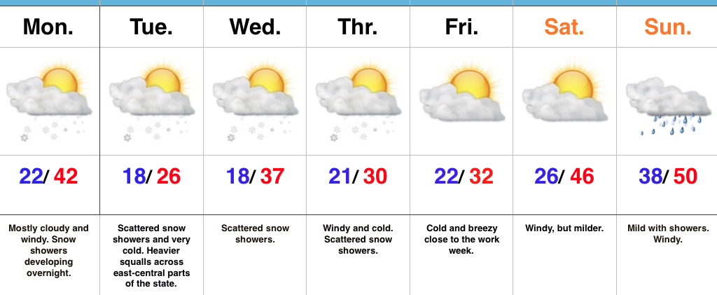
Snow Showers Develop Overnight…Another fast moving upper air disturbance is on the move southeast this morning and will result in a mostly cloudy and blustery open to the work week. As cold air advection (CAA) kicks in overnight and Tuesday, snow showers will develop across the region.  We’ll also note the potential of a more intense and persistent lake effect band setting up across east-central Indiana (where a couple inches will accumulate Tuesday).  If your travels take you into eastern and northeastern portions of the state Tuesday, prepare for sudden drops in visibility and slick travel.

Additional upper level energy will scoot through here during the middle part of the work week and while this will help to reinforce the cold, it’ll also provide scattered snow showers.

We’ll switch gears and get into a briefly milder southwesterly air flow over the upcoming weekend.  Strong and gusty southwest winds will aid in giving a boost to the mercury, but showers will make for a damp end to the weekend.

Upcoming 7-Day Precipitation Forecast:

  • Snowfall: Dusting (for most) to 2″ across east-central Indiana
  • Rainfall: 0.25″

Fast Moving Northwest Flow…

Highlights:

  • Cold times
  • First accumulating snow of the season
  • Additional disturbances to monitor next week

Snow Arrives Late Friday Night And Early Saturday…75% of our Thursday featured overcast skies and periodic flurries and light snow.  Thankfully, a bit of drier air is working in to provide a brighter close to the day.  A cold night is on deck as many fall into the teens.

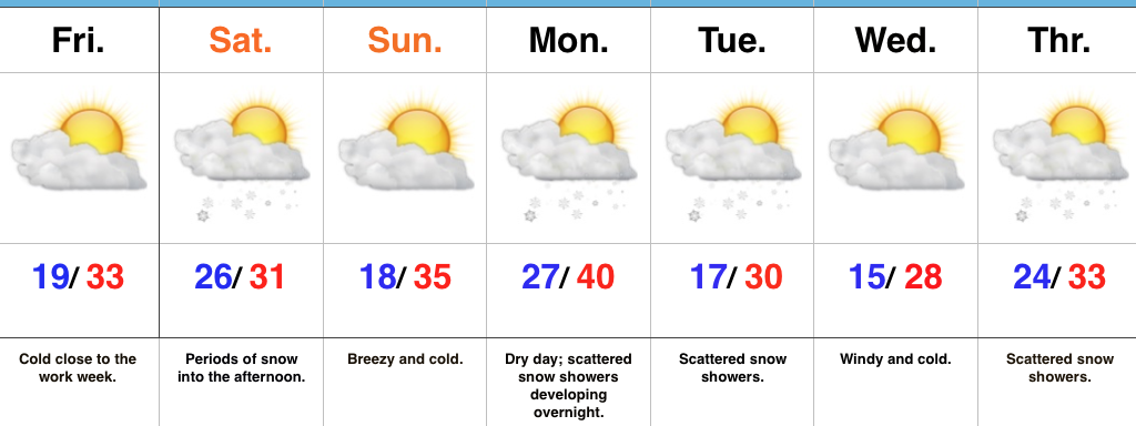
A fast moving upper air disturbance will drop southeast into the Ohio Valley Saturday.  This will help spread a swath of snow across central Indiana overnight Friday into the wee morning hours Saturday.  Additionally, we’ll have to monitor the potential of enhanced lake effect bands across central and east-central portions of the state Saturday morning into the early afternoon.  In general, we expect 1″ to 2″ of snow to accumulate across central Indiana, but note there may be a couple of heavier totals where lake effect bands set up.

Another fast-paced disturbance will blow into town Monday night into Tuesday, followed by another Wednesday night into Thursday.  Cold weather will dominate through the period.

Upcoming 7-Day Precipitation Forecast:

  • Snowfall: 2″ – 3″
  • Rainfall: 0.00″