“It’s Beginning To Look A Lot Like Christmas…”
Highlights:

  • Wet snow today
  • New snow maker for Christmas Eve
  • Turning bitterly cold

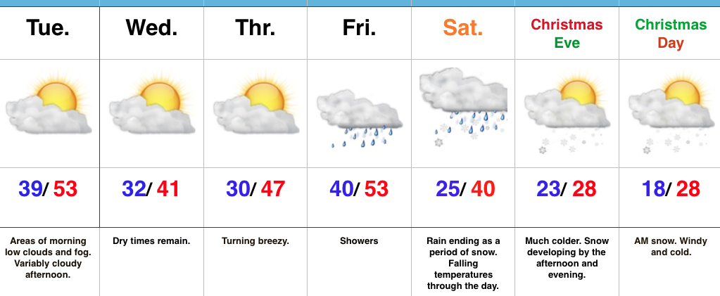
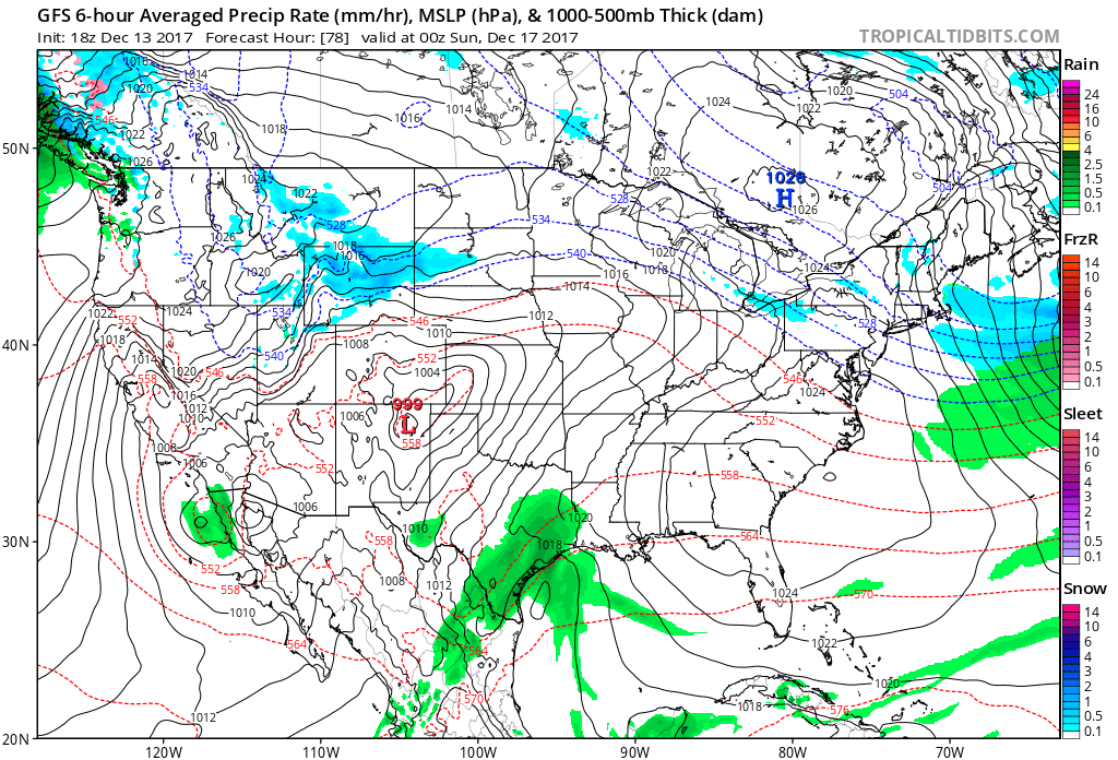
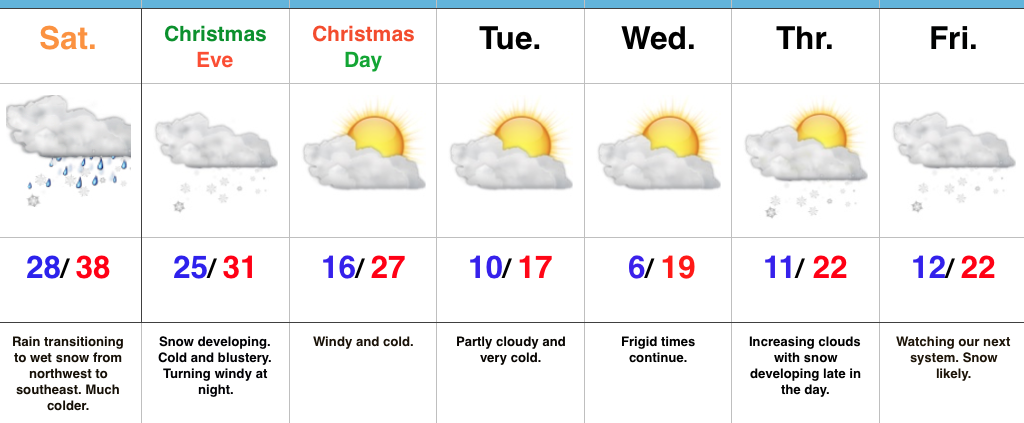
Festive Forecast…Rain changed to wet snow for northwestern ‘burbs between 4a-5a and the transition from wet to white will continue to progress southeast through the morning.  A period of heavy, wet snow will fall through mid and late morning before precipitation begins to taper off.  Our going snowfall forecast from yesterday continues to work with this event (for most it’s a slushy coating to 1″ in and around Indianapolis, increasing to a couple inches north).  We experienced our high temperature for the day shortly after midnight.

Attention will then quickly shift to a new snow maker arriving Christmas Eve.  The day will start dry, but snow will quickly develop as we progress into the afternoon.  At times, snow will come down at a moderate clip and provide a classic setting for your festivities tomorrow evening.  (We’ll have a fresh discussion posted later this afternoon for this event).  Travel safely and leave extra time to reach your destination, as snow will accumulate on roadways.  Additionally, we’ll add wind into the mix tomorrow night into Christmas Day with fresh cold air advection.

Speaking of Christmas, if you’re anticipating Santa to deliver outdoor gifts, you’ll want to plan to bundle up as you head out to enjoy the new toys.  It’ll be a dry, but very cold Christmas.

Cold will remain the weather word to sum up next week and we’ll target the end of next week for the potential next winter event.  It’s a busy, fun pattern if you like winter!

Upcoming 7-Day Precipitation Forecast:

  • Snowfall: 3″ – 5″
  • Rainfall: 0.00″

Mild Now, But The Deep Freeze Awaits; Christmas Snow?

Highlights:

  • Unseasonably mild for now
  • Dry midweek
  • Turning colder and wintry as Christmas approaches

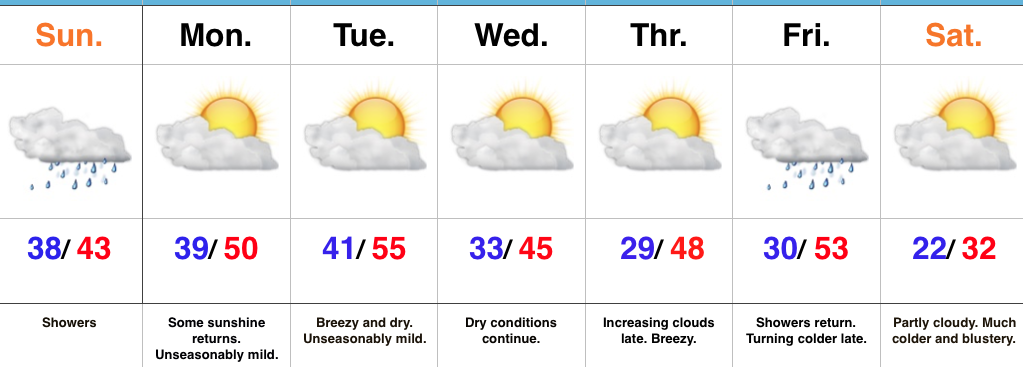
Bottle It Up…By this time next week, most will want to go back in time to the unseasonably pleasant December weather we’re currently experiencing.  If you’re one of these individuals, it’s too bad you just can’t bottle it up for the frigid times that loom.

The short-term period will continue to be dominated by relatively quiet conditions given the time of year.  A storm system will pass to our south Wednesday and provide the Tennessee Valley a good soaking.  We’ll turn cooler for midweek, but remain well above seasonal averages.

A cold front will move towards the region as we wrap up the work week.  This will deliver showers Friday into Saturday before colder air results in a potential transition to wet snow Saturday.  Thereafter, details remain sketchy (at best), but overall confidence is increasing in at least some snow falling during the Christmas Eve – Christmas morning period.

Models are struggling with a second piece of energy that will blow through prior to the big cold blast next week.  Typical model biases are showing themselves this morning (more progressive GFS versus the more amplified European and Canadian).  The best idea at this point is to go with a blend and trend towards a period of snow developing during the afternoon and evening on Christmas Eve, but please understand we’ll have to fine tune things over the next few days.  The other item to consider is that it won’t take much upper energy at all to ring out any available moisture as the arctic intrusion arrives.

Regardless of whether we enjoy Christmas snow or not, the period next week into early parts of 2018 looks particularly cold (at times bitterly so) with additional winter weather opportunities.  Snow removal companies might want to begin stocking up on the coffee!

Upcoming 7-Day Precipitation Forecast:

  • Snowfall: 1″
  • Rainfall:  0.50″ – 0.75″

Mild And Relatively Quiet Week Before Cold Changes For Christmas…

Highlights:

  • Light showers later today
  • Mostly quiet weather week awaits
  • Much colder as Christmas nears

Sunday Showers…A weak weather system is approaching the state as we type this forecast update.  That system will deliver light showers through the afternoon hours, but this won’t be a major weather event by any stretch of the imagination- more of a nuisance than anything.

Our next “event” will come Tuesday night in the form of a dry frontal passage.  This will trend us cooler Wednesday, but still above seasonal norms.  Quiet times will persist with sunshine through midweek, allowing last minute shoppers (no finger pointing here :-)) to at least not have any weather worries as they finish checking off the list!

A more significant cold front will approach as we close the work week.  This will provide showers and gusty winds, followed by a colder feel late in the day.

Looking ahead towards Christmas Eve and Christmas Day, confidence continues to remain high on a much colder pattern taking hold.  However, it’s purely speculative at this point whether we’ll be enjoying “white” for the big day.  Stay tuned.

Upcoming 7-Day Precipitation Forecast:

  • Snowfall: 0.00″
  • Rainfall: 0.20″ – 0.40″


Unseasonably Pleasant Open To The Weekend…

Highlights:

  • “Can’t beat it” weather for mid-December
  • Raw second half of the weekend
  • Changes loom

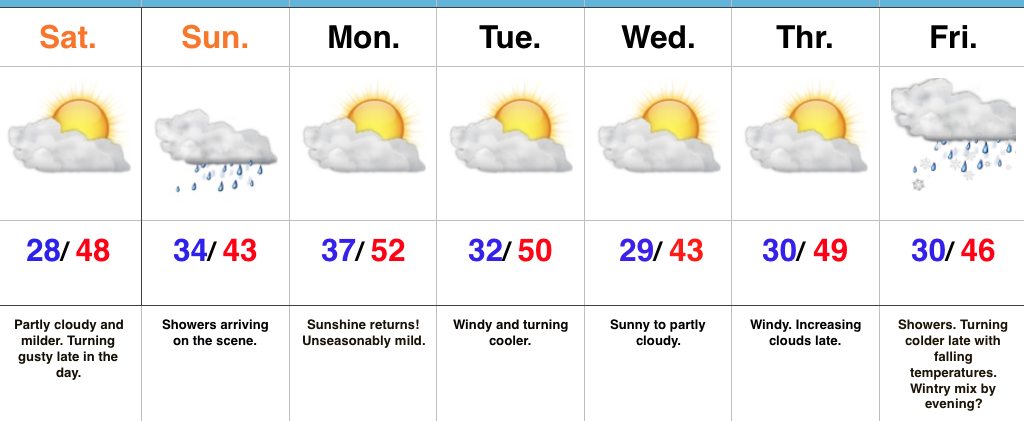
Great Open To The Weekend…High pressure and a relatively mild southwest flow will help boost temperatures to near 50° Saturday afternoon, complete with plentiful sunshine.  We will note an increasingly gusty southwest breeze late in the day.

The second half of the weekend will feature an increasingly wet period, along with a “raw” feel.  Rainfall amounts won’t be particularly impressive, but rain gear will be required on the way out to church Sunday morning.

High pressure will quickly build back in thereafter and remain in control of our work week weather.  A nice stretch of pleasant conditions (by mid-December standards) will prevail, including plentiful sunshine.  Enjoy it as big changes loom.

The all-important Christmas-New Years period is growing ever closer and data continues to suggest we should gear up for busy times in the forecast office.  An active pattern looms, including one that will trend progressively colder.

Upcoming 7-Day Precipitation Forecast:

  • Snowfall: 0.00″
  • Rainfall: 0.10″ – 0.25″

Wednesday Evening Rambles…Cold Reinforcements Tonight; Weekend Moderation…

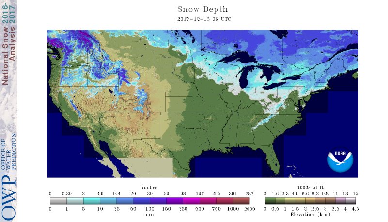
I.  A look at the current snowpack shows the northwest flow nicely, and another storm is just missing central Indiana to the north and northeast this evening (not included in this morning’s snowpack update).  The southern Appalachians have also been capitalizing in this northwest flow pattern, not to mention the southern stream event that dumped hefty snows on the Deep South.

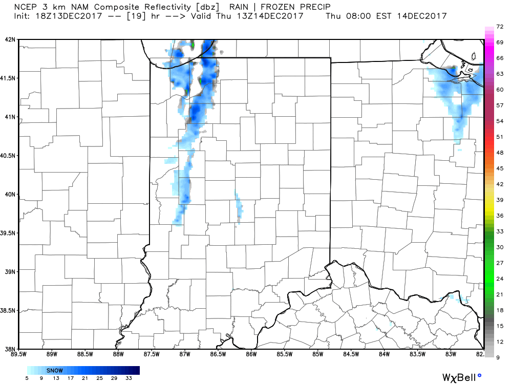
II.  While the sticking snows will miss us this go around, scattered snow showers will impact central IN overnight into early Thursday morning.  There’s also still the potential of a skinny lake effect snow band to impact a narrow portion of western and north-central IN early Thursday.
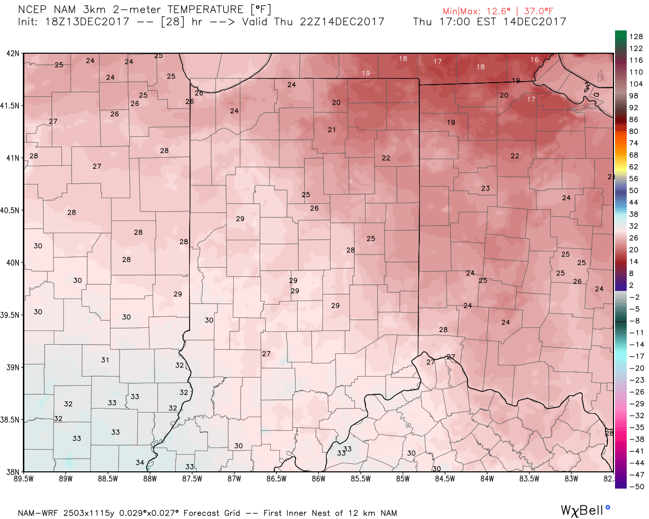
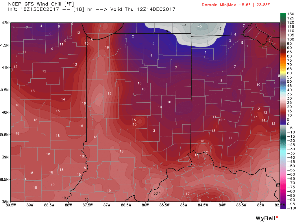
III.  Reinforcing cold air will plunge south Thursday.  Highs will remain below freezing along with wind chill values in the 10s most of the day.
IV: A milder southwesterly air flow will result in slightly “warmer” temperatures this weekend (mid 40s for highs Saturday) before showers arrive to close the weekend.  Despite the slight relaxation of the cold, this will come with a gusty breeze over the weekend.