VIDEO: Pattern Drivers Starting To Align To Deliver More Sustained Cold As We Get Deeper Into Feb?

Updated 01.28.21 @ 6:30p

You must be logged in to view this content. Click Here to become a member of IndyWX.com for full access.  Already a member of IndyWx.com All-Access?  Log-in here.

01.27.21 Weather Bulletin: Snow Builds In This Afternoon For The Southern Half Of The State; Keeping Close Eyes On The Weekend…

Updated 01.27.21 @ 7:51a

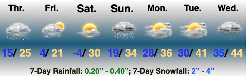
No Rest For The Weary…A fast moving area of low pressure will scoot east this afternoon and evening. This will spread a swath of light to moderate snow across the southern half of the state in the 1p (west) to midnight (exiting southeastern portions of the state) window. While still primarily a light event, models have “beefed up” snow amounts ever so slightly with this system over the past 24 hours. Our snowfall forecast for system #1 can be found below.

Colder air will pour in for all during the overnight and should be just enough to kick up some lake-generated scattered snow shower activity into Thursday morning.

Weak high pressure will then build in and supply a sunny close to the work week. You enjoy the sun and briefly quieter weather and let us worry about the weekend!

Speaking of the weekend, this is the period that continues to look increasingly likely to produce the most impactful winter storm of the season for our immediate area. We forecast early sun to quickly give way to a lowering and thickening cloud canopy Saturday (the sky will have the looks of a snow storm brewing by lunch for most). Precipitation will then overspread the region from southwest to northeast as we progress through the afternoon. The potential is there for a heavy wet snow thump Saturday PM before precipitation transitions to a wintry mix as low pressure scoot by just to our south. Before that transition, “several” inches of wet snow is looking increasingly likely. As colder air wraps back around into the region, wrap-around moisture will fall as light snow and snow showers into early next week.

VIDEO: Short And Long Range Update As We Head Into (At Times) A Snowy Weekend And Get Set To Traverse The 2nd Half Of Jan/ Open Feb…

Updated 01.14.21 @ 6:52p

You must be logged in to view this content. Click Here to become a member of IndyWX.com for full access.  Already a member of IndyWx.com All-Access?  Log-in here.

01.03.21 Weather Bulletin: Snow Ends; Watching Mid – Late Week Next…

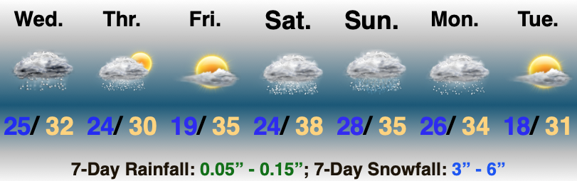
Temperatures Trend Colder Late Week…Upper level energy will scoot out of the region as quickly as it arrived and will take the snow with it. Look for snow to diminish from west to east through mid morning. Heaviest bands of the white stuff set up along and north of the I-70 corridor overnight. While the system tracked a tick further north than originally expected, northern portions of our 2”-4” zone should verify once all is said and done (please keep those reports coming). Southern portions (closer to the I-70 corridor) will bust on the low end. Improving weather conditions are dialed up through the 1st half of the new work week, including a return of the sun! (ENJOY)!

Our next system of note will arrive Thursday into early Friday. Operational guidance continues to struggle with handling of features beyond 3 days out (thanks in part to the maturing high latitude blocking pattern) and this feature will require our attention for the chance of a wintry mix of rain/ snow. Stay tuned as we fine tune!

Drier, colder weather is dialed up to head into next weekend. Enjoy the down time while you have it. A fairly active period of weather seems to loom on the horizon for mid and late month…

Thank you again for your patience with posts (along with video troubles) the past few days. We’ll be settled back into the home office Monday and will resume “regularly scheduled” programming at that time.

Long Range Update: Closing Out Fall And Heading Into Meteorological Winter…

As we’re getting set to turn the page into a new season, modeling already agrees that the overall pattern is very much unlike the big “player” on the field (La Nina). While all Nina (as well as Nino and La Nada) events are different and unique, the “average” La Nina pattern is shown below:

Note both the EPS and GEFS for early December are polar opposite of this traditional La Nina look:

Before we look further at the various data, let’s review the latest teleconnection trends and MJO plots.

Teleconnections: In short, the consensus is it’ll be hard to drive any sort of sustained cold weather into early December. Note the AO is expected to run positive throughout the upcoming couple weeks, the EPO is mostly positive, as well. The one potential “fly in the ointment” that we’ll continue to keep a close eye on? The PNA and whether or not it continues to trend positive down the road.

MJO: This is much more problematic as the data disagrees on what takes place down the road. The European products stall things in the null phase (meaning we need to pay more attention to the teleconnection drivers) while the American data seems to want to take things towards Phase 6 by early Dec. This is interesting on multiple fronts. Obviously having to do with the battle between the models, but also whether the amplitude continues down the road. If (big If) the American model wins out, it could mean we swing things into the colder phases towards mid-December. Again, this is a very low confidence forecast and will require a close eye as we move ahead.

Model Data over the next couple of weeks:

CFSv2 Weeklies- warmth dominates over the next few weeks. Note the model sees the wet pattern in the immediate term before drying us out Week 2. Eventually, the wet pattern is shown to return during the Weeks 3-4 time period.

JMA Weeklies- Similar story to the CFSv2 Weeklies above. Warmth dominates, but what we’ll need to look for is the possibility of the model trending cooler “underneath” with time as the warmth builds over the top. While not an overly cold pattern by any means, should this take place, all of the sudden a rather “boring” pattern from a wintry perspective can flip and become more interesting. Note the precipitation pattern is also similar: wet now, drier Week 2, and a return of the more active times Weeks 3-4.

European Weeklies- Not much difference from the other weekly products with a warm look, overall. Similar to the JMA, we’ll need to watch if the warmth continues to build in Canada which would likely result in cooling across a portion of the Lower 48 (most likely Southeast region first) with future updates.

The overall consensus is it’ll be tough to get any sort of long-lasting well below normal airmass between now and Dec. 10. While it looks warmer than normal through the majority of the next couple of weeks, that’s not to say it’s a pattern without challenges, as pointed out above. (Heck, areas of northern IN may deal with wintry precipitation over the weekend). Of greatest interest, personally, is the PNA trend and watching the models “duke it out” with the MJO.