Winter Having A Tough Time Finding Staying Power…

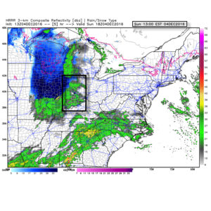
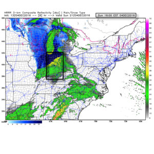
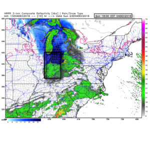
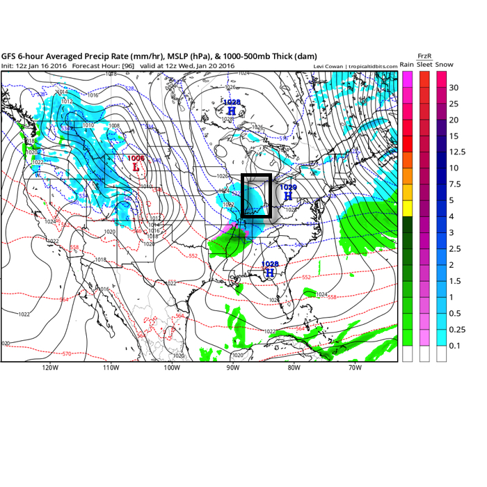
Through (5) weeks of meteorological winter, it’s been a frustrating time for snow and cold weather enthusiasts across the beautiful state of Indiana.  We’ve seen a few storms cut into the central Lakes, taking their respected snow swaths northwest of central Indiana.  Despite an “overachieving” arctic wave on the 13th and an icy glaze event the following Friday night, it’s been a rather uneventful winter so far.  In ironic fashion, a significant winter event is poised to impact portions of the Lower 48 this weekend, but the general consensus in modeling is for this event not to cut northwest, but, instead, remain suppressed and impact portions of the TN Valley and Southern Appalachians with heavy snow.  Now, sure, there’s still time for this to “correct” north, but as of this writing, there’s just as much argument in the suppressed idea.

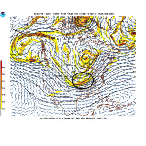
Admittedly, we, personally, believed we would be much farther along in the snowfall department than we are through the first 1/3 of meteorological winter.  Looking ahead, there really isn’t much to “like” about the longer term data as far as getting snow prospects. Sure, an arctic shot is still inbound come mid week with very cold air.  We note AK ridging and blocking “trying” to develop over Greenland.

gfs-ens_z500amean_namer_1
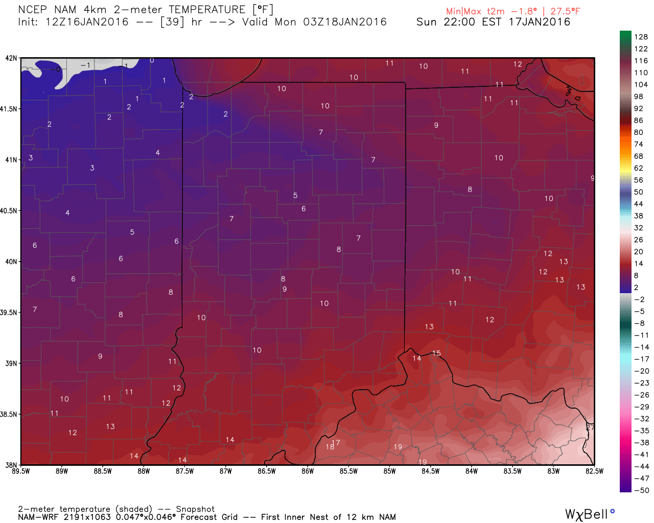
This will take us through mid week and into the weekend with lows in the single digits and lower teens and highs generally in the lower and middle 20s.  We still need to watch Thursday evening-night for a wave of low pressure that may attempt to deliver light snow, but this doesn’t look like a significant event from this distance.

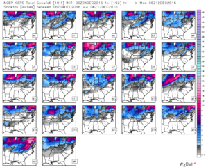
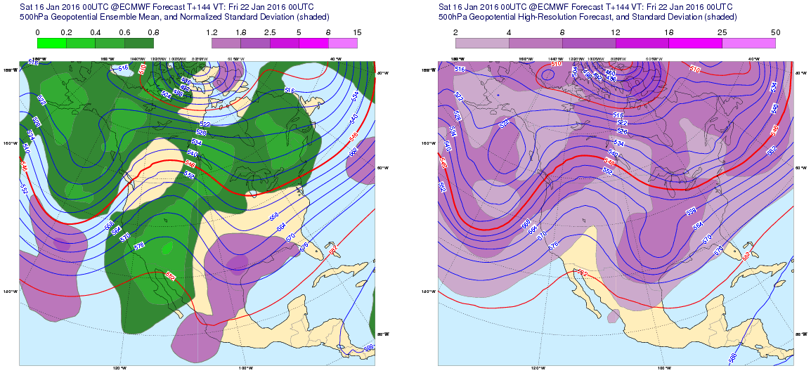
Additionally, we’ll keep a close eye on the weekend for the prospects of snow, but confidence remains very low in regards to this system.  The GFS ensemble members show the wide range of possibilities Saturday.  Taken verbatim, the respected (or not ;-)) solutions, range from “no snow for you” scenarios to a big hit.

gefs_ptype_ens_ky_22To further complicate matters, the European and Canadian solutions are much less robust and result in a more suppressed scenario.  Forecasters (including yours truly) can only wish for the days to return of worrying about respected snow/ mix/ rain lines amongst the various data, versus the present time of models showing a storm only to take it away from run-to-run and other modeling not even showing the storm.

But once to mid-month, the overall pattern is forecast to break down yet again and results in a much warmer look for the east.

gfs-ens_z500amean_namer_12That brings us to our next point and that’s the modeling performance, itself.  For really the better part of a year now, modeling has been poor, at best- even in the short-term solutions.  More recently speaking to the last few months, I can’t recall model data ever performing worse (13 years of forecasting experience).  It leads to a very low confidence forecast in basically anything beyond (7) days right now.  Additionally, conflicting signals are present (as posted this morning, the AO, EPO, WPO favor cold versus the MJO strongly favoring warmth in the longer range).  The signals are competing with themselves to try and take over the overall weather pattern for mid and late winter, but I’m not sure we’re really ever going to get to a point where we “lock-in” to any one particular warm or cold pattern for any sustained length of time this winter.  As far as snow goes, there’s no way in early January you’ll ever see us greatly alter the long-standing ideas posted originally in the winter outlook.  When a given city averages 26″ of snow on the winter, it only takes one storm to come along and put you in a “good spot” (relative to average).  That said, we hear your frustrations (and know they will only grow louder this weekend if our friends down south cash in on the snowy goods).  Once to late January, we’ll revisit this idea.

The one thing we try to do here is eliminate the “noise” in the short, mid, and long range data by analyzing it all and building a forecast using a blend of the said data, along with teleconnections, etc.  You’ll never see us update our forecast based on a model run every time in comes in.  We don’t buy into the idea of “knee jerk” forecasting.  Let’s sit back and watch the next few days unfold.  Unfortunately, in this weather pattern, we just don’t see confidence increasing in forecasts much past the 3-7 day window at this juncture.

Active Wintry Pattern Is Here…

If you’re a fan of cold weather, including being on the field to “cash-in” on multiple winter storm threats, this is a pattern for you.  In all honesty, it’s tough to ask for a better pattern to yield such things.  With that said, each respected storm threat will have its’ own set of challenges that will have to be dealt with.  While we’re confident on IND being above normal in the snow department for the month of December by the 20th, it’s impossible to put numbers (from an accumulation perspective) on specific storm systems from this distance.  With that said, please know that the pattern is one that will have multiple impactful winter events lining up behind one another and it’ll be important to keep updated with forecasts as we progress through the next few weeks.  Needless to say, there will be plenty of opportunities to get those favorite photos with Christmas lights/ decor in the snow this season!

We’re tracking (3) winter systems over the upcoming week:

1.)  Today:  Dry air initially made it difficult for precipitation to make it to the surface this morning.  Heavier precipitation rates will arrive after lunch and fall for a few hours (between 1p-6p for most of central IN).  This will fall as mostly a cold rain from Indy and points south.  Further north, including north-central IN, this will fall as a rain-snow mix (snow should become the predominant form of precipitation shortly after starting.  Across northern portions of the state, this will be mostly snow and we note modeling trending colder with recent runs.  With heavier snowfall rates this afternoon/ evening, travel may become dicey across northern IN and wet snow accumulations of 2″-4″.  A coating to less than 1″ of snow is possible as far south as the northern suburbs of Indy.  The following time stamps can give you an idea what the radar may look like this afternoon into the evening hours.

1p forecast radar
1p forecast radar
4p forecast radar
4p forecast radar
6p forecast radar
6p forecast radar

Temperatures tonight will fall below freezing for most (upper 20s to around 30) and with the lingering moisture on area roadways and sidewalks, a couple slick spots could develop here and there so be mindful.  We don’t anticipate major issues, however.

2.)  Wednesday night-Thursday:  An arctic front will blow into town mid week and we remain bullish on the idea a wave of low pressure delivers a shot of accumulating snow as the arctic plunge moves in.  As we’ve relayed over the past few days, model data is far from being in agreement on this idea, but when one looks at the overall pattern, it’s easy to see how there should be more reflection of low pressure moving along the pressing arctic boundary.  These can be tricky and many times modeling is “forced” to play catch-up at last minute.  For now, we continue with the idea of accumulating snow across central IN in the Wednesday night-Thursday time frame ahead of the coldest air so far this season.  Temperatures will fall to between 10-15 degrees for lows by late week, including single digit ‘chills.

Arctic waves can be tricky in the medium range and must be watched closely.

3.)  Saturday-Sunday:  Our next wintry threat appears to roll into town next weekend.  Similar to mid week, this, too, could be an accumulating event.  It’s far too soon to get specific on timing, snowfall amounts, etc., but just know we’re keeping a close eye on next weekend for potentially more of a widespread wintry event and will sure-up details as we progress deeper into the week.

GFS ensemble members show the snowy pattern ahead over the upcoming week.

Sunday Mix; Heavier Winter Gear Needed Next Week…

screen-shot-2016-12-03-at-9-48-58-amHighlights:

  • Sunday mix
  • Wet Tuesday
  • Midweek snow and turning bitter

Winter Awaits…Today is chilly and dry. Thankfully, we’ll finally get to see the sun.  Enjoy it into the afternoon as clouds will quickly increase yet again later in the day as our next storm system approaches.

Speaking of that next system, moisture will spread into the chilly air mass Sunday morning.  Across central IN, this will fall as a wintry mix of light snow and chilly light rain.  Further north, this will be a mostly snow event, including a light accumulation possible (slushy amounts under 1″) across far northern portions of the state.  All-in-all, this won’t be a big deal.

We’ll have a brief break in between systems Monday before rain returns at night.  This is courtesy of another wave of low pressure lifting out of the northwest Gulf of Mexico, tracking northeast through the TN Valley and into southeastern Ohio.  Central Indiana snow lovers know that’s a classic track for snow around these parts this time of year.  We’ll keep an eye on it, but as of now, the air mass doesn’t look cold enough (yet).

A much colder pattern looms by the middle of next week.  Along with the arrival of the arctic air mass, we also favor a wave of low pressure delivering accumulating snow prospects Wednesday night into Thursday.  (That high Thursday will come at midnight with temperatures crashing through the day).  We’ll turn bitterly cold to close the week, including wind chills falling to around zero.

This is only the beginning of a very cold and wintry period.  There are plenty of “fun and games” awaiting as we rumble through the next couple weeks…

Upcoming 7-Day Precipitation Forecast:

  • Snowfall: 1″ – 3″
  • Rainfall: 0.75″ – 1.25″

Tuesday Morning Rambles…

1.) The month of May has gotten off to a chilly start and given the period of unseasonably chilly air that looms later this week, it’s safe to say these cool anomalies will grow even cooler. 

The coolest day looks to be Saturday with highs only in the mid 50s.


2.) In the shorter term, we’re keeping an eye on strong-severe thunderstorm potential this afternoon and evening across southern and central parts of the state. Large hail and damaging straight line winds are of greatest concern, but a quick spin-up tornado can’t be ruled out.


Not everyone will see heavy rain amounts today, but a few neighborhoods may deal with localized flooding issues as slow moving heavy storms potentially train over communities. Where this happens, 2″+ rain totals are a good bet by midnight.


3.) Forecast models remain in a state of disagreement concerning late this weekend into early next week. The GFS is particularly bullish on the idea of wet (heavy rain threat), chilly times whereas the European is much drier (and warmer). We’ll keep an eye on things and hope for consistency this afternoon. Speaking of this afternoon, we’ll have our updated 7-day posted later today! Make it a great Tuesday. 

Bitter Week Ahead; What About Snow Chances?

January to date is running 2 degrees above normal at IND.  That number will drop significantly this week with the punch of arctic air inbound.

ncep_cfsr_noram_t2m_anom

After a snowy week last week, we’ll attempt to make another run this week.  Despite model inconsistencies, we focus on Sunday morning, Tuesday night-Wednesday morning, and late week for accumulating snow prospects.  More on that in a minute.

Note the difference in snow cover, locally, when compared to this time last year.  Can we get things to look similar to image 2 below come late week?  We’re on the playing field, at the very least.

1

2The arctic surge of bitter air will blast into central IN Sunday morning late into the afternoon. Temperatures will be on the plunge, and reach the single digits come evening.  Wind chill values will go below zero Sunday afternoon.

Forecast temperatures around lunchtime Sunday. Source: Weatherbell.com
Forecast temperatures Sunday evening. Source: Weatherbell.com
Forecast temperatures Sunday evening. Source: Weatherbell.com.

A blast of snow showers and embedded squalls will accompany the arctic surge Sunday morning and may accumulate up to an inch in spots.  Strong and gusty winds will create brief whiteout conditions from time to time.

1We eye the Tuesday night and Wednesday time frame for the next opportunity of accumulating snow.  A “plowable” snow may be in the works during this time frame and we’ll continue to keep a close eye on things.

Wednesday
Wednesday morning as depicted by the 12z GFS. Source: Tropicaltidbits.com

Things remain very active moving forward.  While the model specifics differ significantly at this juncture (no surprise ;-)), it’s important to look at the overall picture and see the potential of a fairly widespread winter event late next week.f144ps2png-atls13-95e2cf679cd58ee9b4db4dd119a05a8d-AYqVLj

Stay tuned.  There are significant differences between the potential of this event and the reality of the past several more significant precipitation makers.  – Namely a blocking cold high to the north as the more significant moisture arrives.  This will help supply the cold and limit the northward track to a point.  Is it a mostly snow event or do we get into the wintry mix potential?   Many questions will have to be answered in the days ahead.