
You must be logged in to view this content. Click Here to become a member of IndyWX.com for full access. Already a member of IndyWx.com All-Access? Log-in here.
Category: Weather Rambles
Permanent link to this article: https://indywx.com/video-spring-like-weekend/
Feb 14
VIDEO: Brief “Speed-Bump” On The Way To A Spring-Like Weekend…
You must be logged in to view this content. Click Here to become a member of IndyWX.com for full access. Already a member of IndyWx.com All-Access? Log-in here.
Permanent link to this article: https://indywx.com/video-brief-speed-bump-on-the-way-to-a-spring-like-weekend/
Feb 03
Friday Morning Rambles; Looking Ahead…
1.) A cold close to the work week can be expected with highs today only topping out in the upper 20s (average highs are in the upper 30s).
 2.) What at one time looked to be a significant weekend storm now may not even deliver any precipitation at all to the region. A flurry is possible, but most should remain precipitation-free this weekend. Expect a gusty southwest wind developing SB Sunday. Highs around freezing Saturday will zoom into the middle 40s Sunday. Lows Saturday morning in the middle 10s will rise into the upper 20s to around 30 Sunday morning.
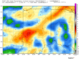
 3.) A more significant storm system will cut for the Great Lakes early next week and this will deliver gusty showers and embedded thunderstorms. A couple of stronger storms aren’t out of the question. Locally heavy rains can be expected, including amounts of 1″-1.5″ (locally heavier totals).

 4.) Cold air will rush back into the region behind the storm and snow showers and squalls are likely by Wednesday.

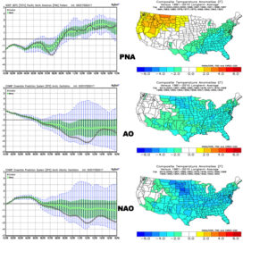
 5.) Longer-term, a real fight is developing on the overall direction we’re heading as February evolves. Analog methods and teleconnections (shown below) would yield bullish cold signals and give hope to winter enthusiasts. However, modeling isn’t in agreement on the wintry ideas. In fact, some modeling is very spring-like as mid-Feb nears. Stay tuned as we try and iron out the details this weekend. Updates will come.
Permanent link to this article: https://indywx.com/friday-morning-rambles-looking-ahead/
Jan 25
Wednesday Morning Weather Brief…
Your complete weekly discussion can be found in the post below from last night, but here’s a recap of our current 7-day:
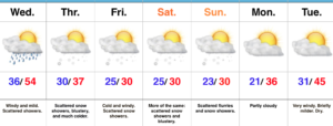 Showers will expand in overall coverage as we progress through the late morning hours, but shouldn’t amount to much (0.10″ for a few neighborhoods). We return to a drier theme this afternoon.
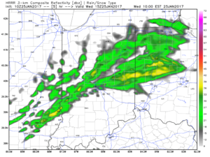
10a forecast radar
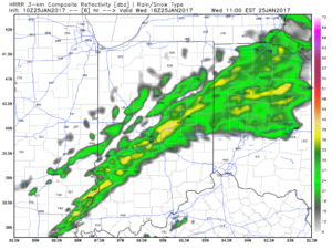
11a forecast radar
A mild and windy afternoon is ahead, including gusts close to 40 MPH and highs in the lower-middle 50s.
Colder air will return tonight and remain in place through the second half of the work week, including the upcoming weekend. Temperatures will grow cold enough Thursday morning for scattered snow showers.
Low-mid 30s Thursday morning
Upper level energy will keep scattered snow showers going late week and on into the weekend. Models can struggle on timing and specifics of the pieces of energy and we’ll keep an eye on things into the weekend. Potential is present for a more “robust” clipper Sunday that could yield better coverage of steady snow showers.
 Longer term, the GFS ensemble continues to show the cold growing deeper and stronger for the region as we progress into early February. Winter is far from over.
Permanent link to this article: https://indywx.com/wednesday-morning-weather-brief/
Jan 24
Winter Returns…
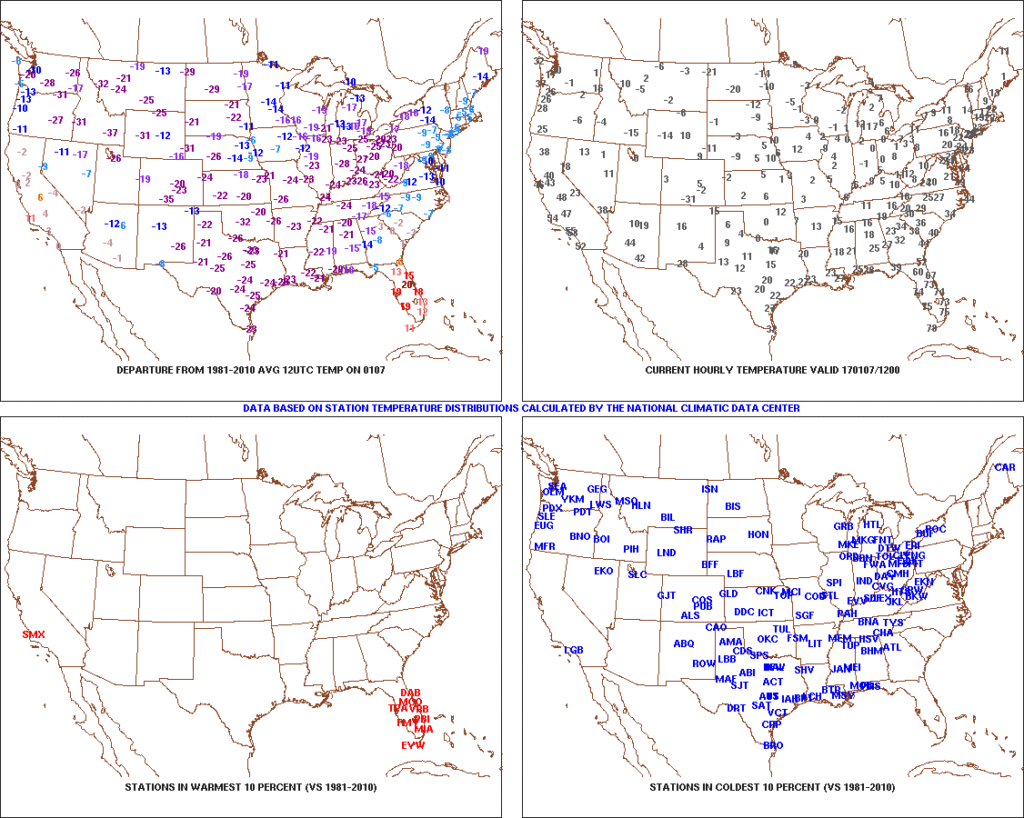
January got off to a frigid start. Remember this coast-to-coast cold, including sub-zero temperatures across central IN, during the first week of the month?
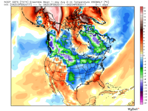
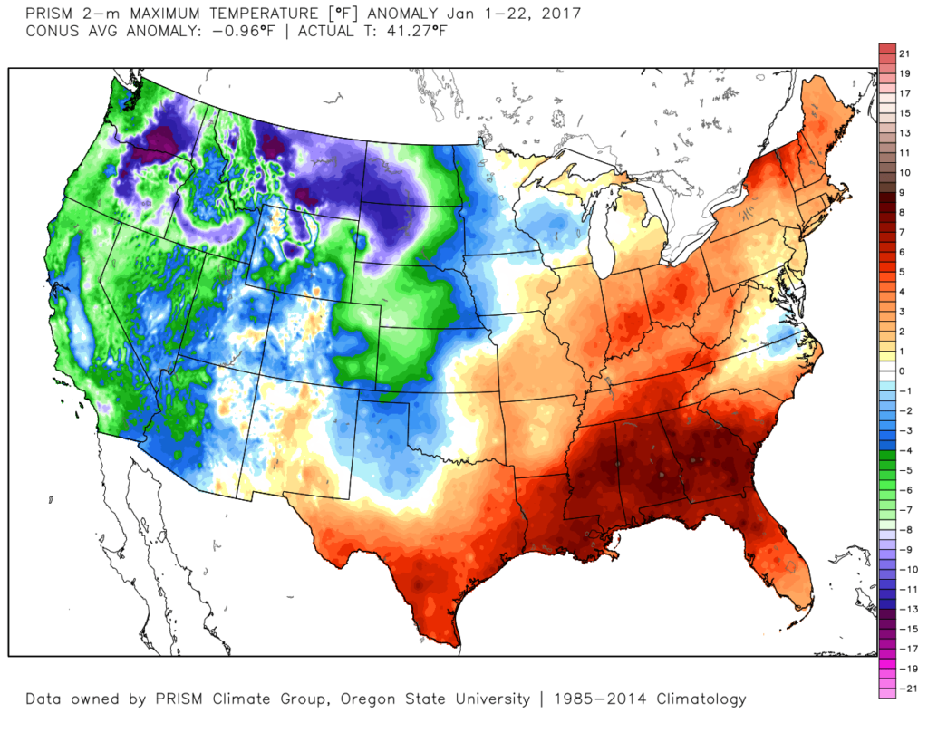
 After the past week to ten days, that frigid open to the month seems like forever ago! The past 7-10 days has featured a significant January thaw, and temperatures now, MTD, are warmer than average across the Ohio Valley. Warmest anomalies can be found across the southeast region.
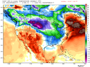
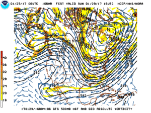
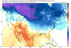
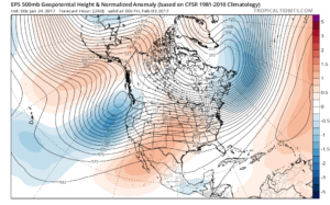
 That said, the pattern is shifting back to winter for the last week of the month and while the duration, longer-term, can be argued, the next 2-3 weeks appear to offer an opportunity to play “catch up” in both the snow and cold departments. Note the developing eastern troughiness. This will bring colder air back into the east as we close January and open February. The GFS ensembles, courtesy of Tropicaltidbits.com, also develops an interesting “blocky” look towards the end of the period in Week 2. Should this verify, it would lead to a better chance of the cold, active pattern locking in.
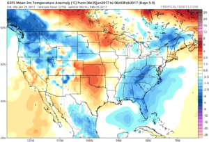
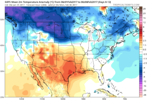
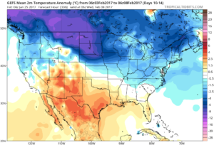
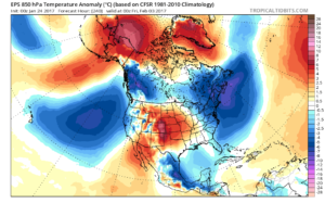
You’re corresponding temperature anomalies show the shift back to a colder than normal regime.
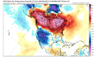
Days 2-6
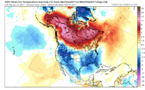
Days 4-8
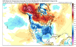
Days 6-10
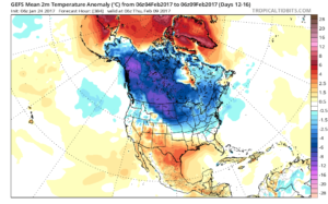
Days 12-16
A fast northwest flow will also result in multiple “pieces” of energy rotating southeast and we’ll forecast a period of snow showers by mid and late week, continuing into the weekend. There’s the chance of a stronger clipper system sometime in the Sunday-Tuesday time frame that we’ll have to keep a close eye on. We want to stress that global modeling will struggle with the specifics (timing and strength) of these clipper systems until within a couple days.
Longer term, while confidence is high on the evolution to a cold, wintry regime through the medium range, the longevity and sustainability of the cold is in question. For instance, by Day 10 (as the GFS continues to drill cold into the region), the European ensembles are much less impressed and suggest the overall transient pattern we’ve dealt with for the balance of the winter continues:
 Thinking here at IndyWx.com believes the European is likely rushing the warmer central look. Time will tell…
**We do note the NEW European Weeklies lock a period of cold into the east from mid-February through early March, including a stormy (snowy) look. Will Old Man Winter have the final say?
Updated 7-day later this evening!
Permanent link to this article: https://indywx.com/winter-returns/