You must be logged in to view this content. Click Here to become a member of IndyWX.com for full access. Already a member of IndyWx.com All-Access? Log-in here.
I. A mostly dry, but breezy weekend is dialed up! A couple light showers may scoot across western portions of the state Saturday, but “light” is the key word.
South winds are expected to gust between 20-25 MPH at times over the weekend. This will deliver milder air with high temperatures reaching the upper 60s to around 70° Saturday and Sunday.
II. An active week is on tap next week with (2) strong cold fronts slated to move through the region.
The first boundary will result in widespread showers and embedded thunder Monday. Most can expect around half an inch of rain with this system to open the work week. Cooler and blustery conditions will return into midweek.
The second cold front will move though late Thursday into Friday and feature another quick pop of rain (relatively light amounts expected at this time) followed by the coldest air mass so far this autumn heading into next weekend.
The air mass will be cold enough to ignite for the first lake effect snow outbreak of the season next weekend.
Finally, we still need to monitor the prospects of additional upper level energy that may try and result in a cold rain or wintry mix just before Halloween. Regardless, Halloween is looking quite chilly this year…
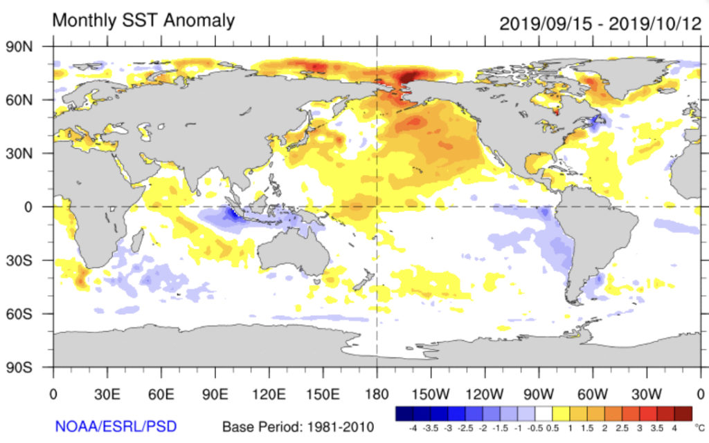
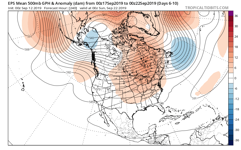
III. Our official annual winter outlook will be released later this month. The latest sea surface temperature anomalies have to make central and eastern winter weather lovers drool. The persistent warmth in the NE PAC should promote a more sustained western ridge/ central and eastern trough this winter when compared to the past couple. More on this and many other factors (including the Modoki Nino event) in the near future…
I. Our Saturday will get off to a stunning start. Despite some patchy fog here and there, look for plentiful sunshine and chilly temperatures in the low-mid 40s rising into the low-mid 70s for afternoon highs with increasing clouds.
II. Those increasing clouds will deliver showers by tonight across central Indiana and then more concentrated heavier rain downstate Sunday evening into the predawn Monday. Southern Indiana is needing a good soaking in a bad way and this system will at least help things slowly begin to improve…
Forecast radar 11p Saturday.
Forecast radar 9a Sunday.
Rainfall totals with this system across central Indiana should accumulate to the tune of 0.20 to 0.40 for most with heavier amounts approaching 1” across the IN-KY border.
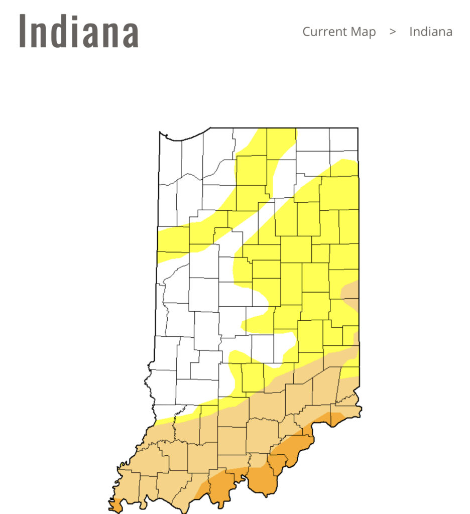
Note this is where things are driest across the state per Thursday’s drought update.
III. Our next storm system will swing through here late in the work week. We’re timing Thursday PM into early Friday for a round of showers and potentially gusty thunderstorms as a cold front pushes through.
Behind this boundary, the coldest air of the fall so far will blow into town. We’re continuing to think many of the area can expect the first frost of the season next weekend.
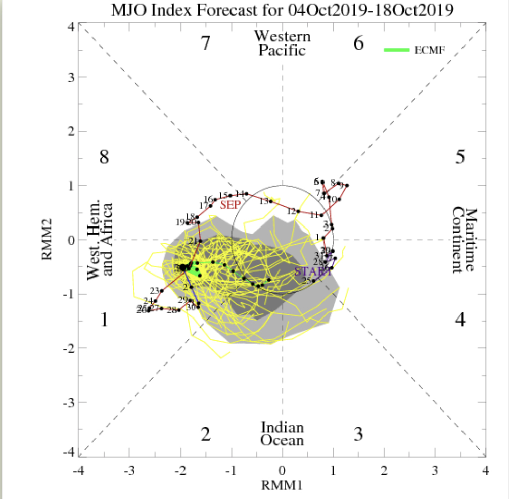
IV. As we look ahead, it’s time to start putting more stock into other tools in the box. Case in point, the MJO is showing signs of less amplitude over the upcoming couple weeks followed by a strongly positive PNA. This supports colder signals in the period. We’ll dig in further in the days ahead.
A “cold front” will pass Friday evening. Despite the threat of a couple widely scattered storms this afternoon/ evening, a broken line of storms may accompany the front Friday afternoon and evening. We’re not expecting widespread rain or storm activity with the passage of this front and some yards won’t see a drop of rain over the next couple of days.
A couple of storms may fire up ahead of the frontal boundary Friday afternoon, but widespread rain isn’t expected.
We’ll notice a wind shift from the southwest to west behind the frontal boundary Friday evening.
While somewhat drier air will briefly work into the region Saturday, temperatures will remain well above average. The humidity will return next week.
As we look ahead over next week, generally quiet conditions are anticipated. The big story in the weather department will be the continuation of summer-like heat and an active time of things in the tropics.
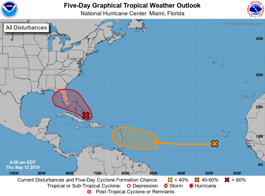
Let’s start with the tropics. Guidance overnight has trended further east with the disturbance that at one time appeared it was heading for the Gulf of Mexico. Instead, our East Coast friends should take note of the disturbed weather in the Caribbean. Some model guidance spins this up into a hurricane over the upcoming weekend as it at least “flirts” with the Southeast US coast (perhaps in an eerily similar fashion as Dorian). The item in the open Atlantic is another we’ll have to keep close eyes on for Week 2 for the Gulf of Mexico. Unfortunately, the upper pattern is a favorable one for the Southeast US coastline to experience a landfall over the next couple of weeks…
That same pattern through the next couple of weeks is also one that will continue to produce an “extended summer” across the East.
As we look ahead to next weekend, there’s the potential of a stronger cold front offering up more organized rain/ storm chances followed by a stronger cool shot. We’ll have more on this threat in our Weekly AG/ Severe Weather Outlook published this weekend.
A cold front will sink south across the state this evening. As the front moves through the area, we expect thunderstorms to increase in coverage and intensity across northern Indiana over the next few hours. These storms should push off to the south during the overnight, weakening as they do so. We still aren’t expecting much in the way of widespread severe weather across immediate central Indiana.
Once the front passes, northwest winds will take over during the predawn hours and help push a drier and cooler brand of air south into the region.
The cold front will move through central Indiana during the overnight hours.
Thereafter, get used to unseasonably cool air, to the tune of what we’d normally expect by late September, for the 2nd half of the week- including this weekend. Mostly dry weather is expected to prevail through the period.
As we look ahead to next week, moderating temperatures are expected next Tuesday and Wednesday, including lower to middle 80s. That said, we do have questions if the warmth will have staying power.
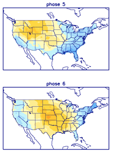
We note the MJO “toying around” with the warmer Phase 6 for a time before returning to Phase 5 (a cooler phase this time of year).
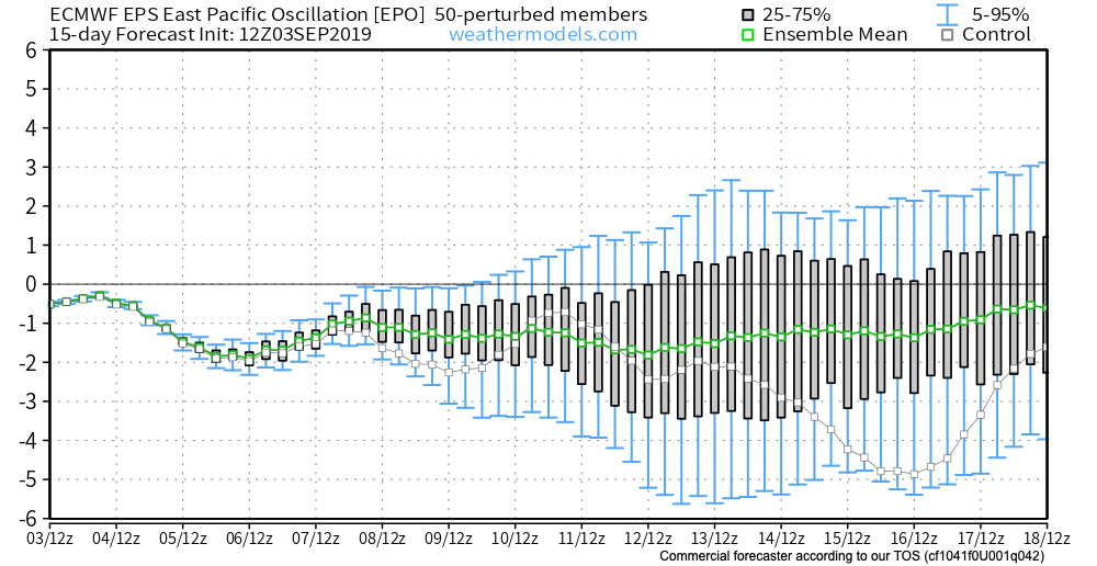
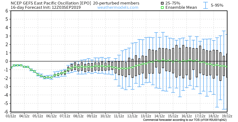
Add in the fact that the EPS and GEFS are in disagreement in handling the EPO in the medium term and this results in lower confidence in the overall staying power of the warmth come mid month.
Unfortunately, this time of year, the tools we can really “lean on” for indications of where the longer range pattern will head are limited (compared to late fall through early spring). That’s when we can really focus on the other drivers such as the AO, NAO, PNA, recurving WPAC tropical activity, etc.
As such, while we continue to believe the pattern trends warmer after the cool spell into the weekend, patience is required with respect to the staying power of said warmth…