Latest Thoughts On Early Next Week; Long Range Update Into Early Jan…

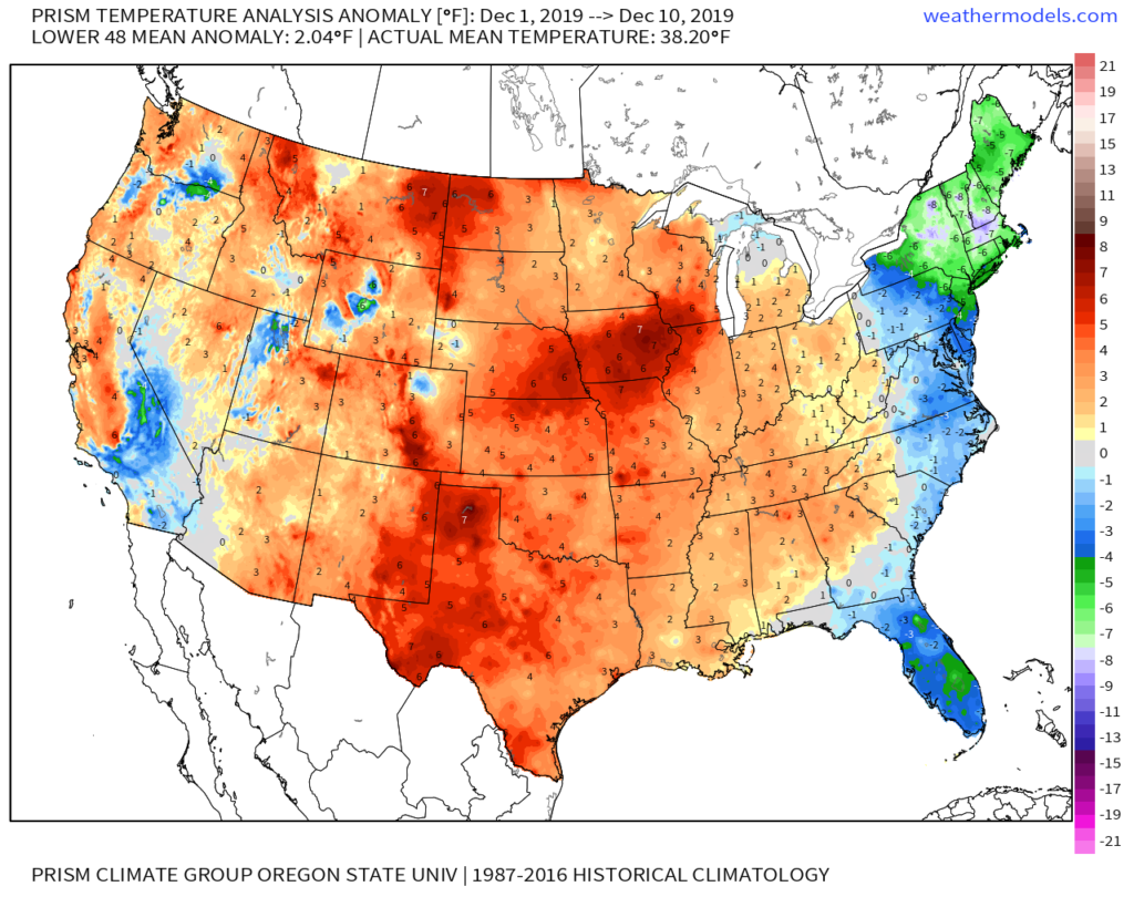
Through the 11th, December is running 1.6° above normal in Indianapolis. This milder than normal theme is rather widespread so far this month through the Lower 48.

As we look ahead, there are continued reasons to believe the pattern will begin to go through more of a transition towards an ultimately more sustained cold pattern as January evolves. We think that transition really started early this week and will feature plenty of “back and forth” over the the next 2-3 weeks before settling into the more sustained cold regime. There will be storms and “rumors of storms” that we’ll have to track through the transitional period, including smack-dab in the heart of the holiday season this year.

The latest JMA Weeklies (update each Thursday morning) shows this “fight” over the next 1-3 weeks.

JMA Weeklies Day 3-9 shows the cold returning to our portion of the country.
The pattern warms significantly across the Plains in the 10-16 day time frame and some of this milder air will try and eject east into the Ohio Valley.

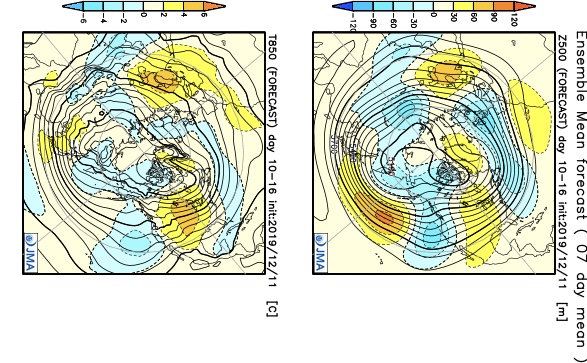
Without blocking in place, the way the JMA Weeklies handle the pattern is likely, but the Weeks 2-3 time period does have a chance to offer up a headache or two as the models may begin to adjust to an increasingly “blocky” time of things.

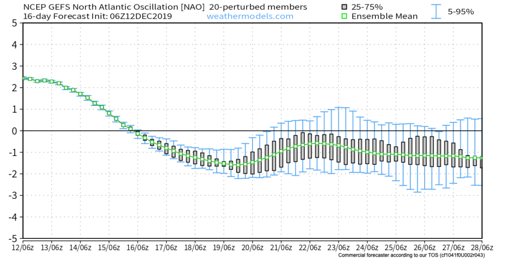
There are at least “hints” that some of the teleconnections that would promote more of a blocky pattern are beginning to align. We caution though that this does take time for these feature to mature and begin to ultimately have a greater impact on our pattern.

The latest GEFS insists on a developing negative EPO in the medium to longer range. We know this favors eastern cold. Eventually, this should, indeed, take place, especially due to the northeast Pacific SST configuration and help drive more long-lasting cold, locally.
Interestingly, the GEFS also depicts a developing negative NAO mid and late December. This can help result in more sustained cold across our portion of the country into the northeast.

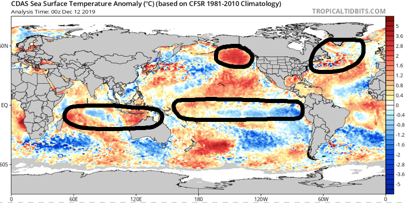
As we revisit the latest SST configuration, there’s continued reason to be very excited about this winter if you’re a fan of colder and snowier than normal conditions. We always knew December would be the tough month before the pattern settles into the mean winter pattern late December into March. Now, time to just sit back and watch things unfold. 🙂

Now, back to the short-term. Despite forecast models very much still in (2) separate worlds, we’ve dug into analogs and looked through countless similar patterns from the past. As model consensus develops (hopefully sooner rather than later), let’s see if they (speaking specifically to the GFS and European) converge on this similar solution for best chances of accumulating snow:

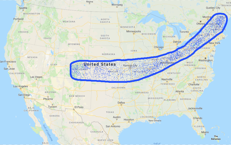
We still have many details to sort through and we caution that this system is far from being etched in stone. You’ll want to keep close tabs on latest developments over the next couple of days. With that said, we’re looking for potential wintry impacts here across central Indiana beginning Sunday night and continuing through Monday.

This evening’s video update will focus solely on the Sunday-Monday system, including the latest model developments from 12z. Have a great Thursday!

Evening Update On Thursday Rain; Weekend Mischief…

Quick update this evening just to touch base on the afternoon/ evening model data.

We’re still anticipating a dry Wednesday, but caution that conditions will be ripe overnight to result in areas of dense fog Wednesday morning. It’ll be wise to allow extra time to work and school in the morning just to be safe.

As we look ahead, rain will return to the region Thursday as an area of low pressure lifts into the Great Lakes region. This will drag a cold front through our region Thursday night into Friday morning. Looking at the most updated high resolution data suggests the steadiest rain will arrive around or just after lunchtime Thursday.

With that said, rainfall amounts aren’t anticipated to be significant. Most will be between 0.10” and 0.25” with a few heavier totals.

After a quiet Friday, moisture will overspread the region once again this weekend. This is the “follower” system modeling has struggled with over the past week. We were confident this would be a local player due to the overall upper level pattern, despite the inconsistent modeling. Sure enough, the consensus of modeling this evening brings in another system in the Saturday-Sunday time frame. With marginally cold air, this isn’t expected to be a widespread winter weather maker, but we continue to closely monitor the potential of localized “more meaningful” wintry precipitation across portions of the central and northern Ohio Valley. Note the wide range of possibilities individual GFS ensemble members print off:

We’ll continue to keep close tabs on things the next couple days and have a fresh update posted early tomorrow morning reviewing the latest overnight data. Specifics should become much more clear with regard to the weekend system once we get to Thursday…

Tuesday Morning Rambles: Record Cold Indeed…

I. Number-Busting Cold: The western half of central Indiana is experiencing downright frigid conditions this morning. Skies that cleared out and combined with the fresh snow pack, along with strong cold air advection overnight now find themselves in the middle single digits! Officially at IND, the low temperature of 9° (as of the 7a hour) sets a record not only for the day, but is the earliest in the fall season that the temperature has fallen into the single digits.

II. Cold Remains: For some perspective on the current cold, average temperatures this time of year include lows in the upper 30s and highs in the middle 50s. Safe to say we won’t be anywhere near those numbers over the next 6-7 days. Even after we pull out of the arctic intrusion over the next couple of days, temperatures will remain well below average through the weekend.

III. Fast Moving Clipper: We’ll keep close tabs on a fast moving clipper system Wednesday night into Thursday morning, but as of now, only expect scattered light snow showers across north-central Indiana Thursday morning with this system (no accumulation anticipated). After this system, we’re talking about a rather dry forecast into early next week. The next chance of precipitation (light rain) would come Monday, but the key word here is “light.”

IV. Looking Ahead: We’ll have a more extensive long range update later this evening. One of the items of interest is the way modeling handles the MJO propagation. While the European isn’t nearly as amplified, the American modeling wants to take the MJO into Phase 2 towards Thanksgiving. Phase 2 this time of year would argue for widespread colder than normal conditions. Again, much more on the long range pattern a bit later.

Tuesday Morning Rambles: A Lot To Talk About…

I. A cold front will slip through central Indiana this evening. After a high near 60 today, temperatures will be stuck in the 40s most of the day tomorrow. To add insult to injury, rain will overspread the state from the southwest late tonight into Wednesday morning.

There will be brief lull in the rain Wednesday evening before rain becomes widespread yet again early Halloween morning. All total, many central Indiana rain gauges can anticipate around 1″ of rainfall with this storm system.

II. Speaking of Halloween, it’ll be important to dress warmly when out and about trick-or-treating Thursday evening. Falling temperatures, increasingly gusty winds, and snow flurries/ scattered snow showers can be expected. How cold? Temperatures will be falling into the lower 30s Thursday evening with a gusty wind (around 30 MPH) resulting in wind chills in the upper 10s to middle 20s.

Precipitation will transition to light snow showers/ flurries Thursday PM.
Wind chills will fall into the upper 10s to middle 20s Thursday PM.

III. The first lake effect snow event of the fall will take place this weekend. Accumulating snow is expected in the snow belt regions- especially Saturday night. Otherwise, the first official freeze of the season can be expected for many across the Ohio Valley this weekend.

IV. Longer term, I’d get used to the cold, more wintry weather. The pattern continues to look much colder than average and active as we rumble through the early part of the month. (In case you didn’t see it last night, our November Outlook can be found here).