Category: Unseasonably Warm
 Highlights:
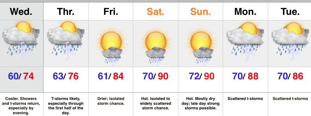
- Periods of showers and storms through mid week
- Can’t shake weekend storm chances, but drier, and turning hot
- Scattered storms return early next week
A frontal boundary will slip south of central IN later this evening and take most of the heavy rain and storms south tonight into a good chunk of Wednesday. However, the boundary will return north Wednesday evening in response to an area of surface low pressure moving northeast out of the lower and middle MS River Valley. This will return the focus of showers and heavier thunderstorms for our region Wednesday evening into the first half of Thursday. Similar to that of today, locally heavy rainfall is a good bet at times.
The area of low pressure will track east Thursday afternoon and take most of the moisture with it. We’ll forecast drier times to wrap up the work week along with rising temperatures. While we can’t shake weekend storm chances, Friday through Sunday will be drier, overall, when compared to the next couple days. With the heat and humidity around, a few strong to severe storms are possible- particularly Sunday afternoon. We’ll keep an eye on things.
Scattered, “splash and dash,” coverage of storms returns early next week.
Upcoming 7-Day Rainfall Forecast: 2″ – 2.5″
Permanent link to this article: https://indywx.com/more-rain-and-storms-ahead/
-
Filed under 7-Day Outlook, Bill, Forecast, Forecast Discussion, Heavy Rain, Rain, Severe Weather, Summer, Tropics, Unseasonably Warm
-
June 18, 2015
 Highlights:
- Afternoon showers and storms
- Watching Bill’s remnants
- Active pattern remains
The day is dawning with overcast skies and humid conditions. Dew points in the lower 70s coupled with lower 70 degree air temperatures have things feeling very tropical. Showers and thunderstorms will fire later this afternoon and a few of these could become strong to severe. With the moisture-laden air mass in place, torrential rainfall will remain likely with storms.
As we shift into Friday and Saturday all eyes will be on the remnant moisture of what once was Tropical Storm Bill. Latest model data focuses in on southern IN for the greatest threat of widespread heavy rain and potential flash flooding, including rainfall amounts of 3″ to 4″ in spots. We’ll continue to keep a close eye on the precise track of Bill’s remnants, but, as of now, folks downstate are at highest risk of flooding problems.
As we move into next week the active and stormy times continue. There are questions in regards to an expanding heat dome. Latest data has backed down dramatically on the potential heat next week. With the wet ground in place it’s hard to argue with that idea.
Upcoming 7-Day Rainfall Potential: 1.5″ – 2″ (locally heavier totals)
Permanent link to this article: https://indywx.com/afternoon-storms-watching-bills-remnants/
June has gotten off to a warm start across the region. It’s been a wet month (to date) across northern regions of our #AGwx viewing area. Bill’s remnant moisture…
You must be logged in to view this content. Click Here to become a member of IndyWX.com for full access. Already a member of IndyWx.com All-Access? Log-in here.
Permanent link to this article: https://indywx.com/ag-weather-report-6-17-15/
Rain and embedded thunder returns after a drier day, overall: Tuesday was a much drier day, overall, and sunshine built into central IN this afternoon to make for a very…
You must be logged in to view this content. Click Here to become a member of IndyWX.com for full access. Already a member of IndyWx.com All-Access? Log-in here.
Permanent link to this article: https://indywx.com/tuesday-evening-catch-up/
 Highlights:
- Best weather of the week is today
- Strong to severe storm potential Sunday and Monday
- Widespread heavy rain threat mid week
- Unsettled pattern continues
We’re opening the weekend with dry skies across central IN, along with a very tropical feel. The combination of a nearby weak boundary and the humid air mass will help fuel isolated to widely scattered storms this afternoon. That said, overall coverage of storms will be reduced from what we saw Friday. Most of the day will feature dry conditions.
We’ll begin to increase storm chances as we rumble into the second half of the weekend and on into the new work week. Some of these may be strong to severe Sunday-Monday, including strong damaging winds and large hail.
Attention will then shift to mid week and the potential of an excessive rainfall event. Modeling is leaning towards tracking a tropical disturbance north out of the western GOM (Gulf of Mexico) before shifting northeast around the periphery of a southeastern ridge. Very heavy rainfall would result if this idea pans out. Stay tuned.
Upcoming 7-Day Rainfall Potential: 2″-4″ (locally heavier totals)
Permanent link to this article: https://indywx.com/today-is-the-pick-of-the-week-wet-and-stormy-pattern-looms/
