You must be logged in to view this content. Click Here to become a member of IndyWX.com for full access. Already a member of IndyWx.com All-Access? Log-in here.
Category: Unseasonably Warm
Permanent link to this article: https://indywx.com/2018/04/29/video-warming-trend-highlights-the-upcoming-week-unsettled-times-return-midweek/
Apr 28
Weekend Rambles: Dry Conditions Remain; Sunday Morning Freeze…
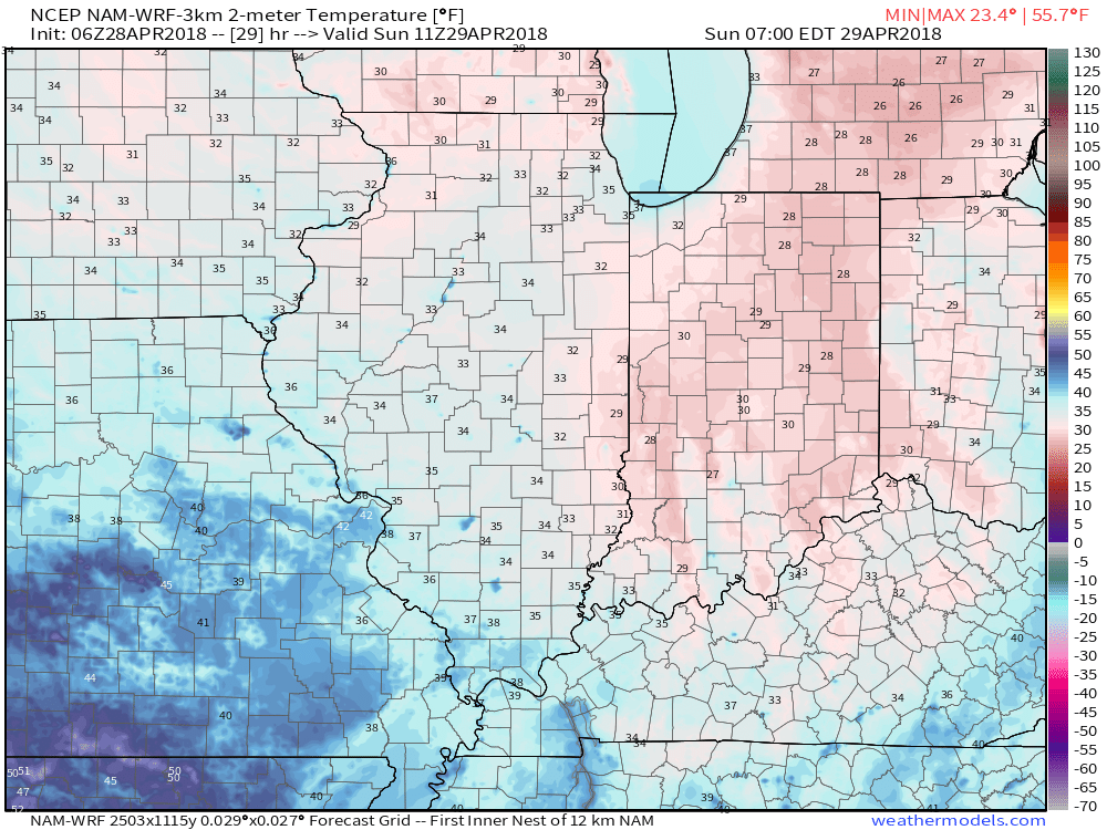
I. A cold front blew through the state last night and we’ll deal with a gusty northerly breeze throughout the day. At times, periods of low clouds will be with us, especially into the early afternoon hours. As skies clear and winds diminish tonight, a hard freeze is likely for most of central Indiana, including the potential of setting a new record low in Indianapolis (record low for Sunday is 31°).
 II. High pressure will build in for the second half of the weekend and remain in control of our weather through the first half of the work week. Dry conditions will remain along with a significant warming trend.
 III. We’ll actually go above normal (for a change) through the early and middle parts of next week, including highs around 80° by Tuesday!
 IV. Unsettled weather returns for the second half of the work week. Models differ on rainfall totals, but we’ll include mention of 7-day totals in the 0.75″ to 1.25″ range- most of which falls Thursday and Friday.
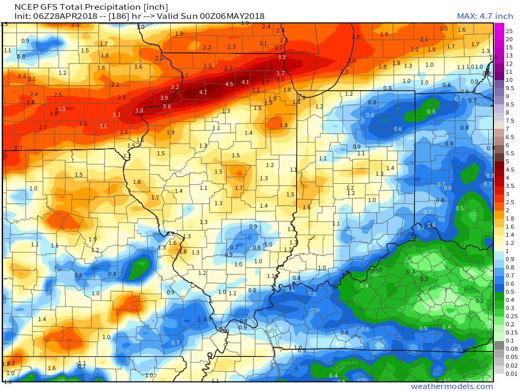
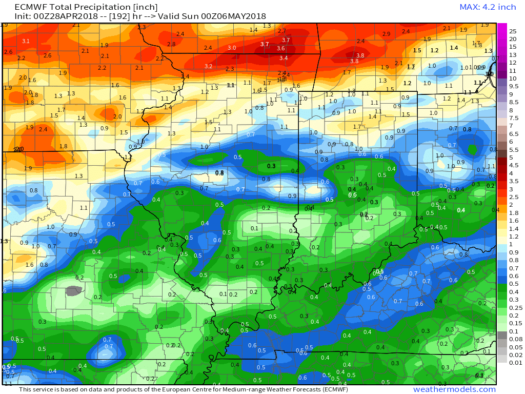 V. Cooler than normal temperatures will return for Week 2 so be sure to enjoy the warmth while we have it next week.

Permanent link to this article: https://indywx.com/2018/04/28/weekend-rambles-dry-conditions-remain-sunday-morning-freeze/
Apr 27
VIDEO: New Record Low Sunday? Looking Ahead To Next Week…
You must be logged in to view this content. Click Here to become a member of IndyWX.com for full access. Already a member of IndyWx.com All-Access? Log-in here.
Permanent link to this article: https://indywx.com/2018/04/27/video-new-record-low-sunday-looking-ahead-to-next-week/
Apr 26
VIDEO: Sunny Close To The Work Week; Frosty Sunday Morning Gives Way To Warming…
You must be logged in to view this content. Click Here to become a member of IndyWX.com for full access. Already a member of IndyWx.com All-Access? Log-in here.
Permanent link to this article: https://indywx.com/2018/04/26/video-sunny-close-to-the-work-week-frosty-sunday-morning-gives-way-to-warming/
Apr 25
Now We’re Talking…
The work week has opened on a gloomy note. Thankfully, improvements are on the way as we look ahead! Despite a small “setback” Friday (scattered shower chance), the majority of the upcoming 10-day period will feature a warming trend and an overall drier than average theme.
Weak high pressure will build into the Ohio Valley through midweek and will result in an increasingly sunny sky Wednesday-Thursday.
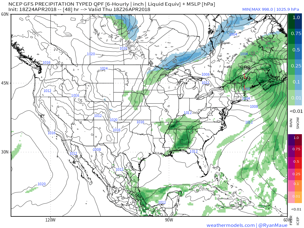 Temperatures will remain cooler than average, but that late-April sun will feel mighty nice, especially after a couple days of “showery” overcast and 50s.
Models are trending drier as we look ahead to Friday’s system and we tend to agree. While we can’t rule out a few showers Friday, this won’t be a significant event (0.10″ for those that do see rain).
 High pressure will quickly build in thereafter and lead to the best weather weekend so far this spring. Saturday and Sunday should feature plentiful sunshine both days. Morning lows will be chilly (upper 30s to lower 40s for most), but daytime highs will zoom into the 60s both days.
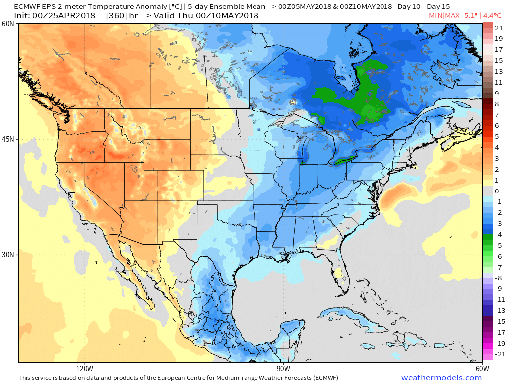
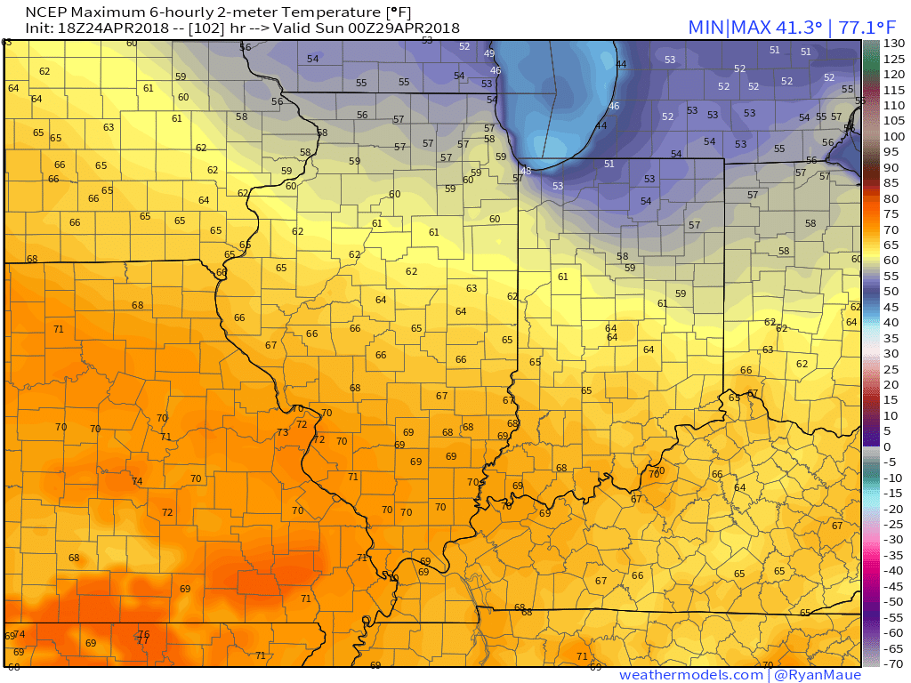 As we look ahead, warmth will continue to build as we open May. Lower 80s seem to be a good bet as we move into next week, but before we get into sustained warmth, another “setback” or two seems to be a good bet. We note the EPS showing this nicely as cooler anomalies return by Week 2.

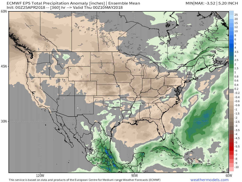
 It remains a drier than overall pattern over the upcoming couple weeks. The next storm of any significance is slated for an arrival late next week (Thursday time frame).
Permanent link to this article: https://indywx.com/2018/04/25/now-were-talking-3/
Apr 23
VIDEO: Looking Ahead To The Best Weather Weekend (So Far) This Spring…
You must be logged in to view this content. Click Here to become a member of IndyWX.com for full access. Already a member of IndyWx.com All-Access? Log-in here.
Permanent link to this article: https://indywx.com/2018/04/23/video-looking-ahead-to-the-best-weather-weekend-so-far-this-spring/
Apr 23
Turning Significantly Warmer Towards The End Of The 10-Day Period…
The upcoming 10-days will run cooler than normal, overall, but it’s the cool on the front end that will be most noticeable before a nice warming trend develops towards the weekend and into early parts of Week 2.
 After a chilly work week (relative to average), 60s will return this weekend and temperatures will zip into the lower and middle 70s early next week, before approaching 80° by the middle of next week.
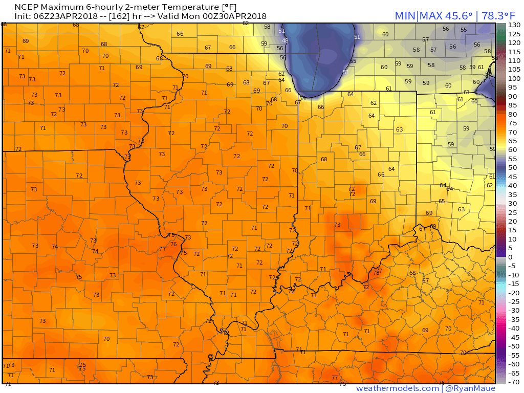 Despite the showers that will impact central Indiana today, it’s mostly a dry pattern over the upcoming 10-day period. Additional rain chances will continue Tuesday (scattered, nuisance-level) and with a frontal passage Friday. With that said, 10-day rainfall will only run between one half and three quarters of an inch for most of the region.
The majority of the Ohio Valley will run drier than normal through the period.

Permanent link to this article: https://indywx.com/2018/04/23/turning-significantly-warmer-towards-the-end-of-the-10-day-period/
Apr 16
Looking Ahead To The Merry Month Of May…
Folks are growing tired of the cold and snow, and for good reason; it’s mid-April for goodness sakes. As of today, we’re currently ranked as the 5th snowiest spring (March-May) in recorded history, with Indianapolis recording 14.2″ thus far. By the way, we’re only .3″ from moving into the 4th place spot.
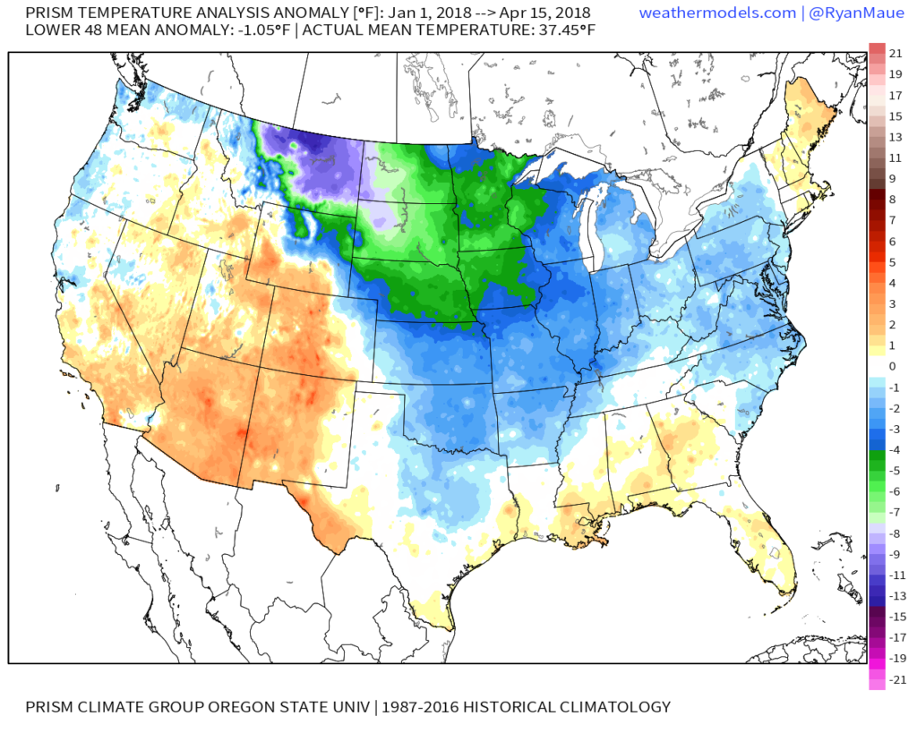
With that said, it’s not just April that’s been unusually cold and snowy, but the entire year thus far. As of April 15th, year-to-date CONUS temperatures are running more than 1° below average:
 More specific to Indianapolis, here’s the monthly temperature breakdown so far for 2018:
- April: 5.7° below normal (MTD)
- March: 3.3° below normal
- February: 5.6° above normal
- January: 3.0° below normal
As we look ahead, there are a couple of key items that we’re monitoring closely to get a better idea as to where this pattern is heading as we rumble into the merry month of May:
NAO- does it show signs of finally flipping to a positive state with any sort of duration?
MJO- does it go into the “wheelhouse” or continue to rumble into the milder phases (5 and 6 this time of year)?
The North Atlantic Oscillation (NAO) is a bit troubling as it shows signs of heading towards a negative phase once again as we open the month of May. This would promote the threat of colder than normal temperatures continuing in early May. With that said, May is the first month of the next several (until winter returns) where the overall influence of the NAO state begins to lessen it’s grip. Unlike from the mid and late winter months into the early spring (Jan through April), mid and late spring, through the fall, isn’t controlled by the NAO. With May being a “transition” month, we’ll favor a colder than average pattern continuing during the early portion of May as the NAO looks to trend negative. As we move towards mid and late month, we won’t rely on the NAO like we have been lately as the said influence “wanes.”
The Madden Julian Oscillation (MJO) is forecast by most data to head towards the “null” phase. The consensus of modeling takes it into the wheelhouse after traversing Phase 3 (present) which is a cold phase. The end result? Unfortunately, we can’t rely on the MJO with any sort of confidence from this distance for the month of May.
Looking at the data itself, the CFSv2 and European Weeklies (just to name a couple) show conflicting ideas. The CFSv2 (courtesy of weatherbell.com) is in the warmer than normal camp for May while the NEW European Weeklies (courtesy of weathermodels.com) suggest the chill lingers throughout the month.


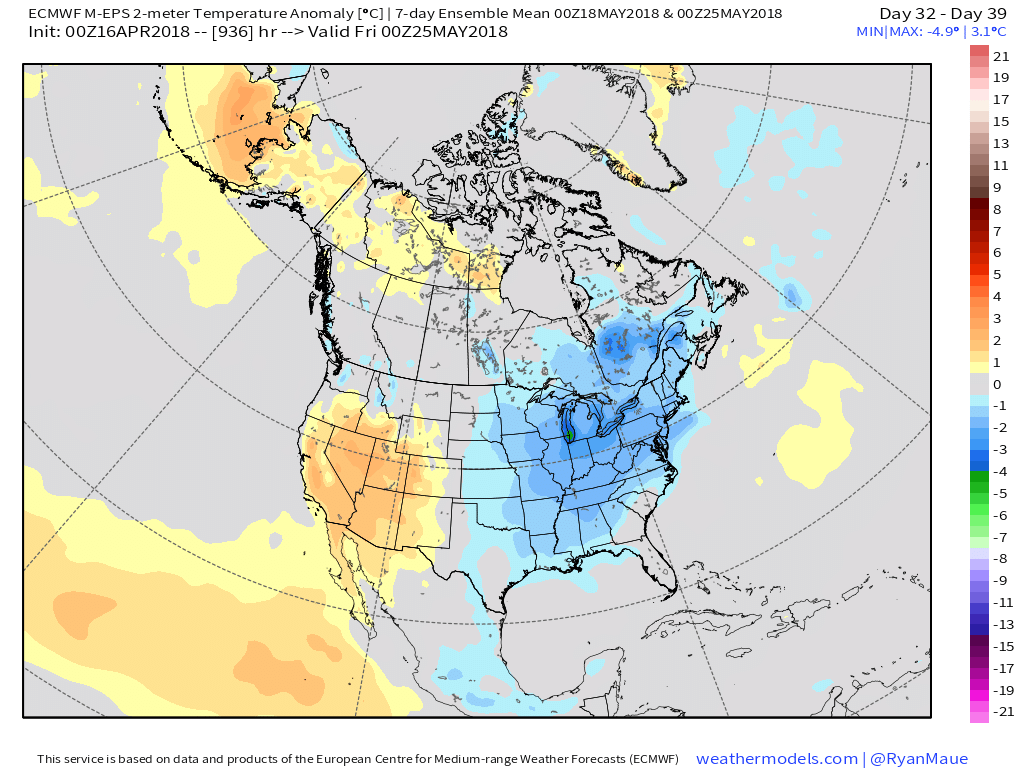 While we have conflicting temperature ideas, both suggest a drier than average month emerging:
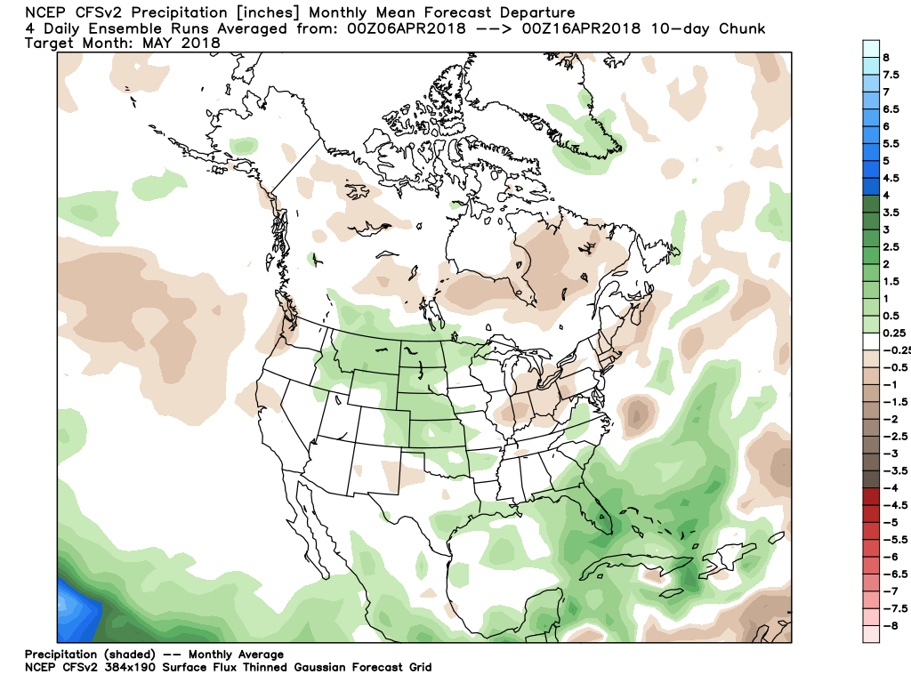
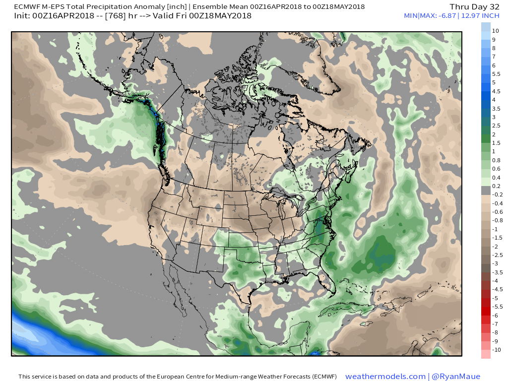
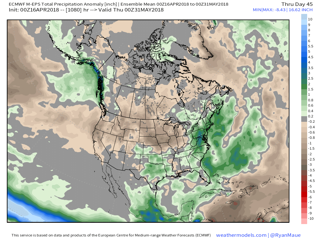 At the end of the day, our call on May’s forecast from mid-April would be for an early cooler than average start before flipping towards more of a seasonable to slightly warmer than normal regime. Our idea all along this spring has been that when this pattern flips, the potential is present to jump right to a summery feel. In the face of the new European Weeklies, we still feel this warmer idea mid and late May is on the table. We’re in agreement with the data of a drier than average month.
Permanent link to this article: https://indywx.com/2018/04/16/looking-ahead-to-the-merry-month-of-may/
Apr 13
VIDEO: Looking At The Weekend And Next Week…
You must be logged in to view this content. Click Here to become a member of IndyWX.com for full access. Already a member of IndyWx.com All-Access? Log-in here.
Permanent link to this article: https://indywx.com/2018/04/13/video-looking-at-the-weekend-and-next-week/
Apr 12
VIDEO: “Backdoor” Cold Front Presents Weekend Challenges; Active Close To April…
You must be logged in to view this content. Click Here to become a member of IndyWX.com for full access. Already a member of IndyWx.com All-Access? Log-in here.
Permanent link to this article: https://indywx.com/2018/04/12/video-backdoor-cold-front-presents-weekend-challenges-active-close-to-april/
