https://youtu.be/_5kethxFEUw
You must be logged in to view this content. Click Here to become a member of IndyWX.com for full access. Already a member of IndyWx.com All-Access? Log-in here.

Apr 17
https://youtu.be/_5kethxFEUw
You must be logged in to view this content. Click Here to become a member of IndyWX.com for full access. Already a member of IndyWx.com All-Access? Log-in here.
Permanent link to this article: https://indywx.com/friday-evening-video-update-3/
Apr 17
 Highlights:
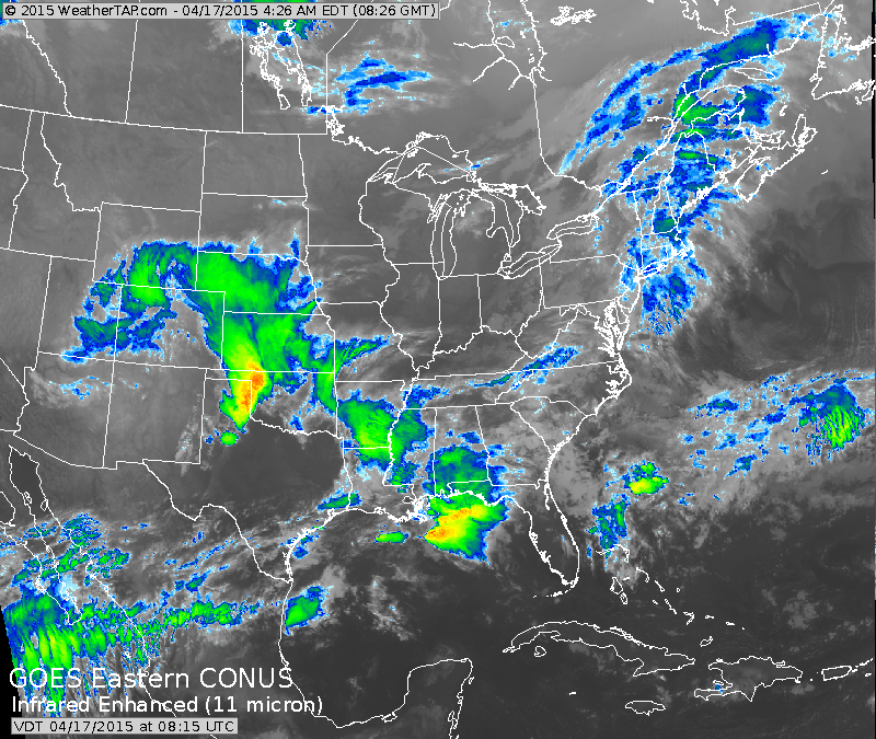 The infrared satellite this morning, courtesy of Weathertap.com, is showing a significant storm system dumping major snows along the CO Front Range. Additionally, later today, this storm system will help spawn a severe weather outbreak across eastern CO, NE, and KS.
Locally, we have no weather worries after we rid ourselves of the dense fog currently in place across central Indiana. Once the fog burns off it’s nothing but sunshine and warmth and an absolute ideal close to the work week and open to the weekend. Highs today (image 1) will reach the lower to middle 70s and we forecast highs Saturday in the upper 70s (image 2), both courtesy of Weatherbell.com.

 Things will begin to transition to stormy times for the second half of the weekend as a “piece” of that big Rocky Mountain storm system breaks away and helps develop a new surface low over the MS River Valley. This low pressure system will ride into the Ohio Valley and provide widespread showers and thunderstorms Sunday.
Here’s a look at the 2p forecast radar Sunday, courtesy of Weatherbell.com.
 The Storm Prediction Center has outlined far southern portions of the state for a Slight Risk of severe weather Sunday.
 As we turn our attention to next week, unseasonably cool air will engulf a large portion of the east. Reinforcing chilly air will push in later next week, after the first surge of chill arrives Monday night/ Tuesday.

Permanent link to this article: https://indywx.com/warm-now-but-cooler-times-loom/
Apr 16
 Warm And Dry To Close The Week; MUCH Cooler Next Week…After a wet and noisy night for some, we can’t rule out a shower or thunderstorm really at any time today, particularly across southeastern parts of the state. However, most of the day will be dry.
Drier air will win out tonight and set the stage for a beautiful and warm close to the week. Both Friday and Saturday look to offer lots of sunshine and well above normal warmth! Get out and enjoy, friends!
A cold front will move into the region Sunday into Monday with widespread showers and thunderstorms. Some of these storms may be strong. Stay tuned.
The story next week will be one that’s MUCH cooler. The weather pattern will shift in rather drastic fashion to wrap up the month. Gone will be the warm southwesterly air flow we’ve come to enjoy most of the month and in it’s place will be a significant trough and associated northwest flow. As such, we can expect multiple surges of cooler than normal air during the last 7-10 days of the month.
Upcoming 7-Day Precipitation Forecast:
Permanent link to this article: https://indywx.com/warm-close-to-the-week/
Apr 14
 Not As Bad As It May Look…Most of the day Wednesday will feature dry conditions and pleasant temperatures. Moisture will stream in from the south Wednesday evening and nighttime showers will develop across central Indiana, continuing into Thursday (though we can also expect several dry hours).
Friday will also feature mostly dry conditions, but we’ll maintain a mention of a widely scattered shower. Overall, increasing sunshine and a southerly air flow will help boost temperatures into the lower 70s Friday.
The weekend features lots of questions as two of our more trusted computer models are in totally different camps as of this evening. The European suggests dry and warm conditions (a great weekend, weather-wise) will rule; however, the GFS model is more unsettled and cooler. For now we’ll take a blend of the two, leaning more towards the GFS due to better run-to-run consistency. Stay tuned as updates will be required.
Cooler air will become the story as we open next week and jackets may be needed Tuesday with a gusty northwest breeze.
Upcoming 7-Day Precipitation Forecast:
Permanent link to this article: https://indywx.com/weekend-questions/
Apr 14
April so far has run much warmer than normal across our region, and a large part of the country. However, a rather significant shift in the pattern will take…
You must be logged in to view this content. Click Here to become a member of IndyWX.com for full access. Already a member of IndyWx.com All-Access? Log-in here.
Permanent link to this article: https://indywx.com/cooler-times-ahead/