Category: Unseasonably Cool Weather
Rain Changes To Snow Today; Busy Pattern Into Early December…

Screen Shot 2015-11-21 at 7.47.29 AMHighlights:

  • Rain changes to snow
  • Early season arctic air settles in
  • Next storm arrives for Thanksgiving
  • Eyeing a cold open to December

Our storm system is arriving on schedule this morning as rain is overspreading central IN.  Just north of the city, snow flurries are falling as we type this (Boone County).  Further north it’s mainly a snow event.  Elsewhere, rain will continue to overspread the region before transitioning to snow from late morning into the early afternoon from northwest to southeast.

Here’s what the radar may look like as we progress from morning into the afternoon

8aSat

Forecast radar 8a, courtesy of Weatherbell.com

10a forecast radar, courtesy of Weatherbell.com

10a forecast radar, courtesy of Weatherbell.com

Forecast radar at 1p, courtesy of Weatherbell.com

Forecast radar at 1p, courtesy of Weatherbell.com


Forecast radar 2p, courtesy of Weatherbell.com

Forecast radar 2p, courtesy of Weatherbell.com

We think rain will transition to snow for Indianapolis, itself, just after lunch and may come down heavily for a time from early afternoon into the mid afternoon hours before tapering off as evening arrives.  While it may be falling “fast and furious” for a time, warm surface temperatures will limit accumulations from what they would be otherwise.  Here’s our updated snowfall map.

112115SnowMap3The big concern this evening will be flash freezing as a gusty NW flows travels over a fresh snowpack just to our north and helps temperatures plummet into the teens tonight.  Wind chills in the single digits can be expected followed by highs tomorrow only in the 20s.

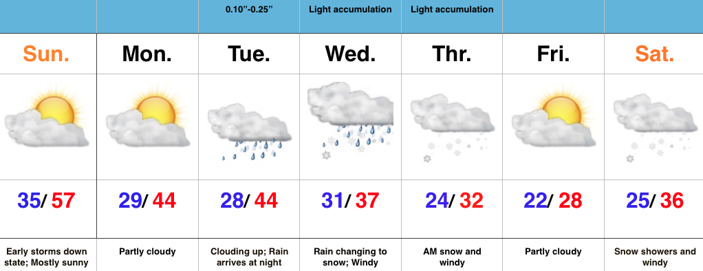
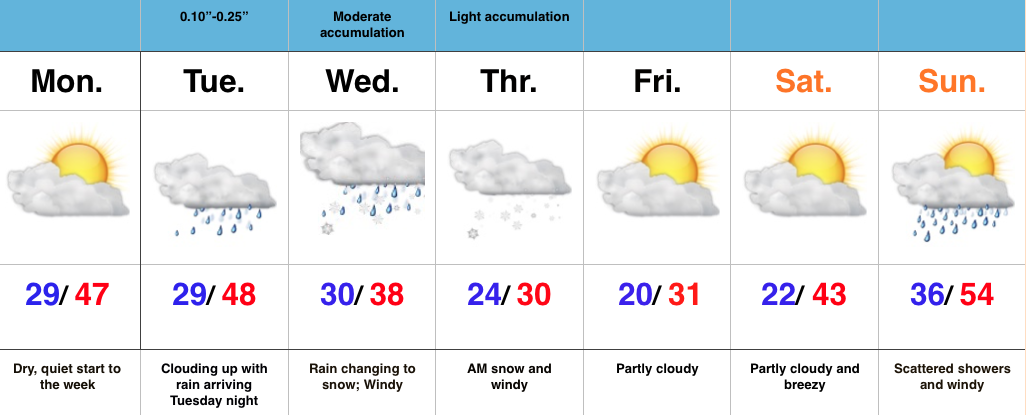
Moderation will occur as we move through Thanksgiving week before our next storm system arrives late Thanksgiving Day.  Rain and breezy conditions will move in late Thursday into Friday before a much colder air mass oozes into the state late in the period.  This may set the stage for a rather “interesting” open for December as a storm system tries to “attack” the cold…

Permanent link to this article: https://indywx.com/rain-changes-to-snow-today-busy-pattern-into-early-december/

Potent System; Friday Evening Thinking…

This evening’s radar shows our potent weather maker providing a plethora of weather elements to our west.  Anything from heavy snow (numerous 12″ + reports coming in across IA) to thunderstorms across MO have made for an active Friday evening.

9pRadarThinking hasn’t changed much from the get go with this storm system, but we wanted to “freshen” things up a bit before bed.

Rain will overspread central IN through the morning hours before transitioning to snow from late morning into the early afternoon.  This transition will occur in a northwest to southeast fashion as colder air wraps into the region.

Here’s a timeline (thanks to Weatherbell.com) of what the radar may look like as Saturday morning progresses into Saturday afternoon.

8aSat

12pSatAs rain transitions to snow, it’ll likely come down rather “fast and furious” for a time before ending.  Despite what may be moderate to heavy snow for a time (especially along and north of the I-70 corridor- there’s the “magic” dividing line again :-)), warm surface temperatures will really limit what snow will actually accumulate.  As things stand now, we still forecast a widespread 2″-4″ snowfall across the northern portions of the state, with 4″-6″ amounts in favored lake effect areas.  Farther south to include central IN, a dusting to less than 1″ is a good bet before precipitation ends.

The growing concern Saturday night will be a stiff northwest wind driving MUCH colder air into the region.  This will help power a brief lake effect event across NE areas of the state before shutting down quickly by the wee morning hours Sunday.

LakeEffectAny lingering moisture on area roadways will freeze up quickly tomorrow night.  With a deep snowpack just to our north, the NW flow will keep things very cold around these parts into early next week.  Note widespread teens Sunday morning across north-central IN and even this might not be cold enough.  If we lay the expected snowfall down, don’t be surprised by some single digit temperatures (not counting wind chill values) across north-central IN Sunday morning.  Highs Sunday will remain below freezing for most.

‘Tis the season!  More in the AM, and happy snow dreams to all!

teens

Permanent link to this article: https://indywx.com/potent-system-friday-evening-thinking/

First Snow Of The Season And Early December Talk…

You must be logged in to view this content. Click Here to become a member of IndyWX.com for full access.  Already a member of IndyWx.com All-Access?  Log-in here.

Permanent link to this article: https://indywx.com/first-snow-of-the-season-and-early-december-talk/

Wet Today; Colder Air Coming…

Screen Shot 2015-11-18 at 7.15.50 AMHighlights:

  • Rain today
  • Breezy and turning cooler
  • Secondary push of early season arctic air

Our big autumn storm system is swirling through the central Plains this morning.  It’ll begin to pick up forward momentum and head northeast over the next 24 hours.

We’re dealing with an impressive fetch of moisture (w/ a Gulf of Mexico connection) this morning and that’ll help feed embedded heavy downpours this morning into the early afternoon.  Here’s a time stamp of forecast radar images, courtesy of Weatherbell.com.

7aSimRadar

11aSimRadar

3pSimRadarAs mentioned above, with a GOM connection, embedded heavy rain will dampen your Wednesday activities.  On average, we’ll add an additional half inch to inch of rain today (that’s on top of what we saw Monday and Tuesday).

RaintotalsOnce to tomorrow all eyes will be on our next storm system that will eventually help pull down the season’s first blast of arctic air.  Ahead of the cold surge, expect light rain to end as light snow across central IN Saturday.  This won’t be a big deal from an accumulation perspective, but it’s always exciting seeing the first snow flakes of the season.  Further north, across our northern tier of counties, a couple inches of snow will be possible.

SatPMStormTrackWe’re also keeping a close eye on Thanksgiving’s weather.  While still a bit early to be specific, initial thoughts suggest we’re dealing with a storm on, or just on either side of Thanksgiving, that will provide rain to begin, but we caution that another surge of early season arctic air looks to pour in behind that storm system and potentially set the stage for a more impactful winter event to open December.  More on that in the days ahead…

Permanent link to this article: https://indywx.com/wet-today-colder-air-coming/

Couple Storms To Watch And Much Colder Air…

Screen Shot 2015-11-17 at 7.30.17 AMHighlights:

  • Periods of rain
  • Turning cooler
  • Next storm offers up wintry precipitation for parts of the state
  • Early arctic blast

Periods of rain will continue into the mid to late afternoon across central IN as “wave 2” of our current storm system moves through.  We’ve added a couple simulated radar images below, courtesy of Weatherbell.com.

9aFuture

2pFutureThis is all in association with a significant autumn storm system that’s been responsible for delivering hefty snows across the Rockies, blizzard conditions across the High Plains, and severe weather across the central and southern Plains.  This storm will lift northeast over the next 24-36 hours.

TuePM

WedPMA third, and final, wave of moisture will push through the state Wednesday, in a weakened state from what our friends to the west will experience (where another round of severe is expected today and tonight).  This is what the radar may look like mid-morning-ish Wednesday.

10aWedFutureWhen all is totaled up from rain that began Monday afternoon and ends Wednesday afternoon, many locales will pick up 1.5″-2″ of needed rainfall.  While significant, those numbers are lower than what originally model data implied, but we’ll take what we can get to push closer to average for November rainfall.

All eyes will then shift to our second storm system that will arrive over the weekend.  There are still more questions than answers in regards to track of this next “wave” of low pressure, but with much colder air in place and pouring in behind the system, snow will fly across northern IN.  As of now we forecast the majority of this event to fall in a liquid form across central IN, but even here precipitation may end as light snow showers the way things stand now.  Stay tuned as we continue to fine tune the track. Regardless, much colder air will be with us to end the period.

Permanent link to this article: https://indywx.com/couple-storms-to-watch-and-much-colder-air/