So Long Warm Autumn Weather; Colder Changes Ahead This Week…
 Highlights:
- Bye-bye unseasonably warm weather
- Wet start to the work week
- Colder times loom
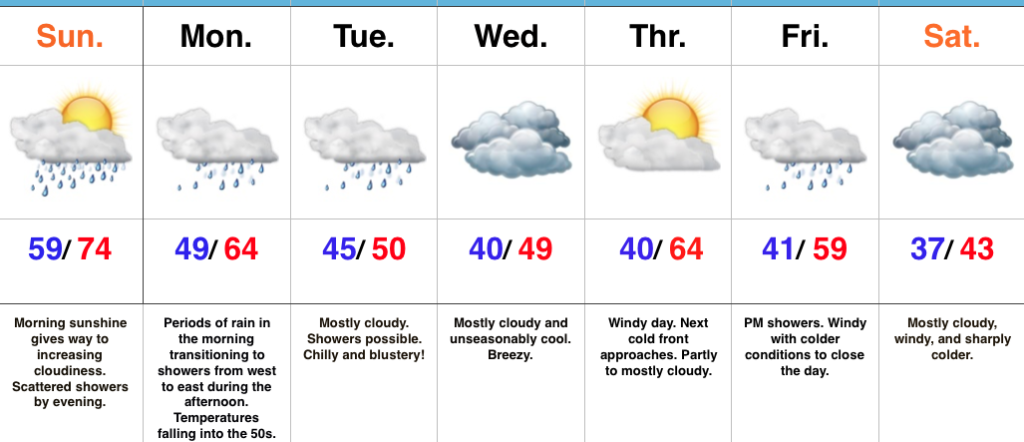
Early Sunday Sun; Rain Increases In Coverage Tonight…The morning is off to a pleasant start, including unseasonably mild conditions and a SW breeze. Clouds will thicken up this evening and a scattered shower will be possible. Rain will increase in coverage and intensity tonight into Monday as an area of low pressure tracks into the Ohio Valley and eastern Great Lakes by Tuesday morning. Steadiest rain will impact central Indiana Monday morning before diminishing to showers Monday afternoon and evening. Temperatures will fall into the 50s Monday morning into the afternoon.
A bigger “jab” of chilly air will plunge into the region for midweek. Considerable cloudiness will accompany the unseasonably chilly conditions, along with a gusty northwest breeze.
As we look ahead towards next weekend, another in a series of cold fronts (get used to that) will eye a Friday evening approach. Showers will be possible as this front blows through the region. Sharply colder air looms next weekend. Frost and freeze conditions will likely develop early next week, along with the first flakes of the season…
The 2017-2018 IndyWx.com Winter Outlook is now available!
Upcoming 7-Day Precipitation Forecast:
- Snowfall: 0.00″
- Rainfall: 1.25″ – 1.75″
 Highlights:
 Highlights: