Category: Unseasonably Cool Weather

Tuesday Evening Weather Notebook…

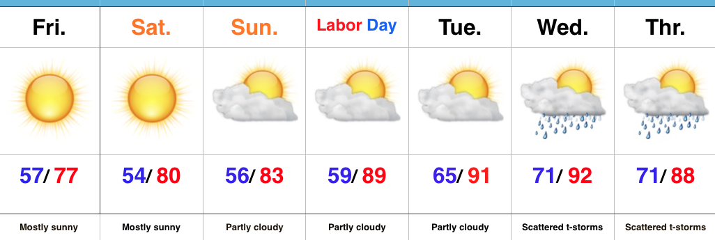
It’s been a cool and dry start to the month of September. Through the first few days, IND is running 0.70° below normal and 0.44″ below average precipitation. 


The upper ridge currently in place will deliver more late summer heat through the end of the work week. It’ll remain mostly dry, as well. 


Much better rain and storm chances will have to be built into our forecast Friday into Saturday, courtesy of a cold front moving into the region. 


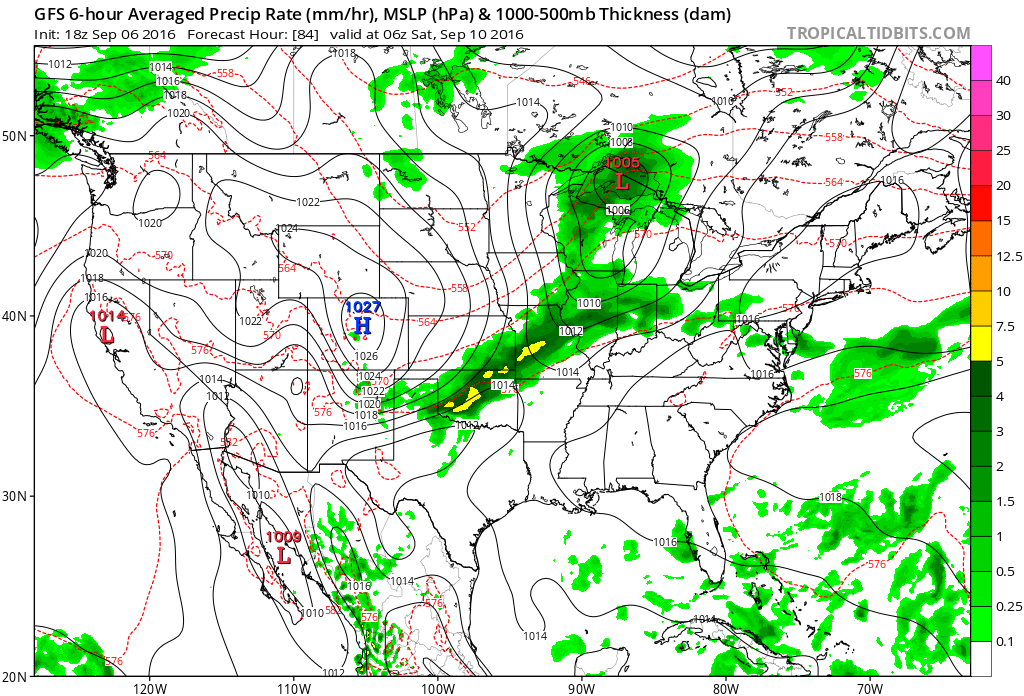
A much cooler regime will settle into the region over the weekend. Highs behind the front in the 70s with lows in the 50s will be common- after rain potential of 1″-1.5″ for most. 


A reinforcing shot of cool air will arrive the middle of the following week. Early indications suggest the second shot of fall-like air will be even cooler than this weekends’ and could feature widespread 40s at night. 

Permanent link to this article: https://indywx.com/tuesday-evening-weather-notebook/

New SST CA Model Weighs In On Winter…

The updated Sea Surface Temperature Constructed Analog model is in for the winter. In short, it suggests a slow start to winter gains momentum and turns much colder as mid and late winter arrive. It’s also a stormy look, locally, and would imply big-hitter potential in the Ohio Valley.

500mb pattern

*Note how the trough becomes more established over the central and east during the January through March period. 

Temperature anomalies


The consistency is remarkable on the bullish cold signal for the central and east for the January-March time frame. We note high agreement, month-over-month, on the J-M time frame being significantly cold. 

Precipitation anomalies

*No doubt a stormy signal through the Ohio Valley.

Time is ticking…winter will be here before we know it! Our official annual winter outlook will be out in October. 

Permanent link to this article: https://indywx.com/new-sst-ca-model-weighs-in-on-winter/

Warmth Next Week Gives Way To A Cool Mid Month…

The refreshingly cool couple days we’ve recently enjoyed will begin to give way to moderating temperatures today.  Humidity levels will remain pleasant and it’ll be a great Labor Day weekend to spend time outdoors.  Highs will top out around 80 today and into the middle 80s Sunday.  Labor Day will feature the mercury climbing closer to the 90 degree mark.  – Fitting, I suppose, for the unofficial end to summer.

Humidity levels will be on the uptick come Monday evening and Tuesday as Gulf moisture is transported northward.

GulfMoistureIt’ll be a downright hot week, as well.  Temperatures will top out around 90 through the end of the short work week.

gfs-ens_T2maMean_us_4
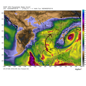
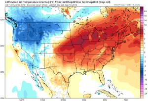
As we rumble into next weekend and the following week indications continue to point towards wetter and cooler times.

After a dry week ahead, rain and storms will come with that increased humidity next weekend.

gfs-ens_apcpna_us_7
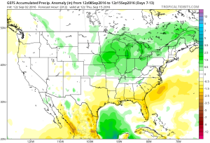
Early numbers off the press suggest 1″-2″ rains possible next weekend.

The increased rain and storm chances signal another shift in the pattern towards a cooler one just beyond the Day 10 period.  From experience, I would look for this trough around mid month to trend deeper (more significant) as time draws closer.

gfs-ens_z500a_us_47
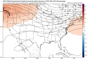
It’s possible the first push of widespread 40s loom around the middle of the month.  Time will tell…

Permanent link to this article: https://indywx.com/warmth-next-week-gives-way-to-a-cool-mid-month/

Hot Weather Returns…

Screen Shot 2016-09-02 at 7.24.49 AMHighlights:

  • Sun-filled days
  • Turning hot
  • Storm chances return by mid week

Refreshing Temperatures (For Now)…High pressure and a dry northeast flow will continue to support refreshing conditions across the region.  Plentiful sunshine along with low humidity values will create ideal weather to spend time outdoors as we go into the long Labor Day weekend.  Perhaps a bonfire is in order this evening?

Eventually, our air flow will back around to the southwest and this will allow a much warmer and increasingly humid air mass to return.  Sunday will be noticeably hotter, but the true push of humidity will arrive Labor Day into Tuesday.  It’ll, officially, feel “oppressive” by mid week.  That increased moisture will also help ignite scattered storm chances Wednesday into Thursday.

Looking just beyond the (7) day period shows the potential of a cooler period building back in next weekend…

Upcoming 7-Day Precipitation Forecast:

  • Snowfall: 0.00″
  • Rainfall: 0.25″-0.50″

Permanent link to this article: https://indywx.com/hot-weather-returns/

VIDEO: More on Hermine and the Labor Day Weekend…


You must be logged in to view this content. Click Here to become a member of IndyWX.com for full access.  Already a member of IndyWx.com All-Access?  Log-in here.

Permanent link to this article: https://indywx.com/video-more-on-hermine-and-the-labor-day-weekend/