Central Indiana will enjoy a nice open to the weekend. High pressure will scoot off to the east and allow a warmer, but blustery return southwesterly flow. Though we’ll be warmer tomorrow, winds will increase and gust to 30-40 MPH late in the day. Highs will top out in the middle to upper 70s.
 Sunday will feature an increase in cloudiness, but most shower activity should remain across northern and north-central parts of the state. Even in areas that receive rain Sunday, amounts will be light and insignificant. Here’s a look at what the radar may look like Sunday afternoon. It’ll be another unseasonably warm day as highs top out between 75°-80°, despite the increase in cloud cover.

Speaking of warmth, that will be the major story for early and middle parts of the work week. Highs around 80° and warm overnight lows in the 60s (where our average high should be) can be expected with dry, but windy, conditions in play. Extended summer, anyone?!

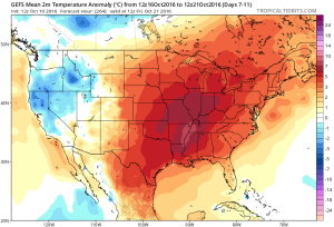
Changes are brewing for the latter portion of the week and that will require most of our attention over the weekend as far as sifting through the various details. While confidence is high in a transition to drastically cooler conditions, the evolution of specifics concerning rain chances results in a much lower level of confidence. As it stands now, we’ll increase rain chances for the late week period (late Wednesday into Thursday), but the duration of wet weather is up in the air. The GEFS (below) shows the wetter pattern returning.


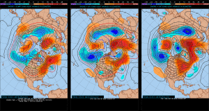
Note the various ensemble solutions (above) of how the upper air pattern may look in the 8-10 day period. Solutions range from a drier and downright chilly look (European) to one that’s cooler, but still unsettled (GFS, GEM). Time is required to continue to fine tune things.
All of that said, as previously mentioned, we’re much more confident in the cooler look to close October. The GEFS sees that, as well.

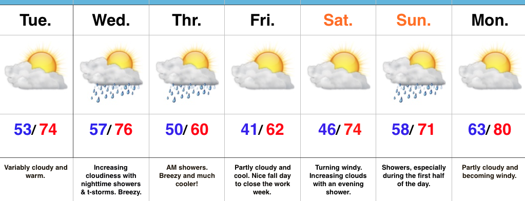
 Tuesday will remain rain-free across the region, along with pleasant temperatures and humidity levels (mid 70s after a low in the lower 50s).
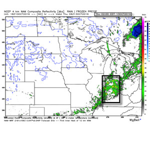 Rainfall amounts don’t look particularly impressive; generally 0.10″-0.25″ during the Wednesday night-Thursday morning time frame.
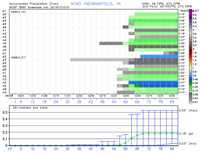 The cool air flowing in behind the front is impressive though. In fact, highs both Thursday and Friday will likely only reach the lower 60s (if that).
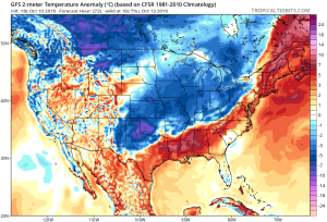 Despite the chilly air that will be with us to wrap up the work week, ensemble data is in excellent agreement on a significant warmer than average regime developing under a big eastern ridge in the 6-10 day. This will likely promote highs into the lower 80s next week for a few days. Impressive, no doubt, considering we’ll be rumbling through the second half of October by that point.