Not As Bad As It May Look…
Screen Shot 2016-05-23 at 6.48.20 PMHighlights:

  • Dry feel turns much more humid
  • Splash and dash storms, but many dry hours
  • Warm, humid Memorial Day/ Race weekend

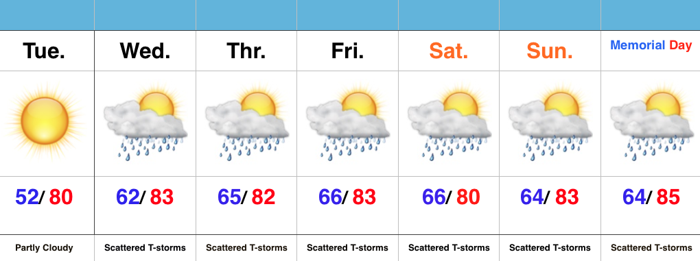
One More Dry Day…High pressure is scooting away from the region, but will remain close enough to supply central IN with dry conditions Tuesday.  Though warm, we’ll enjoy one more day with dry air in place.

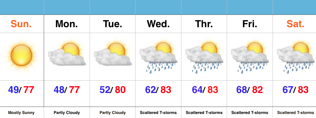
A SW wind shift will deliver an increasingly moist air mass for mid week, continuing into the long holiday and race weekend ahead.  In fact, dew points will surge to readings around 70 (downright oppressive).  While there will be times of scattered showers and thunderstorms, there will also be many dry hours, as well.  We continue to keep an eye on Wednesday for the potential of a strong to severe storm.

As we continue to grow closer to the holiday and race weekend, questions continue to increase around the forecast specifics, and rightfully so.  While we need to be prepared for an afternoon/ evening storm, these will be scattered and there will be “haves and have nots” when it comes to storm/ rain activity over the balance of the upcoming forecast period.  Again, we want to emphasize there should be plenty of dry time.
Feeling Like Summer…

Screen Shot 2016-05-22 at 8.27.39 AMHighlights:

  • Dry open to the week
  • Warming up and turning humid
  • Storm chances mid week on

Beautiful Open To The Week…High pressure and a dry air mass will result in lots of sunshine to open the week.  After a chilly first few weeks of May, we’ll see improvements in the mercury this week.  A dry air mass will still result in cool overnight lows through Tuesday morning, but we’ll shift to a much more humid regime for mid and late week.  Additionally, temperatures will continue to climb into the lower 80s for highs.  Prepare to sweat.

The increased moisture and an approaching frontal boundary will help ignite scattered showers and thunderstorms for the second half of the week.  We also have a close eye on Wednesday for the potential of strong to severe thunderstorms.  While it won’t rain the entire time, prepare for “splash and dash” showers and storms into the important Memorial Day/ Indy 500 weekend…

Showers Build In This Afternoon…

Screen Shot 2016-05-20 at 8.04.29 AMHighlights:

  • Showers arrive this afternoon
  • Better finish to the weekend
  • Wet pattern returns next week

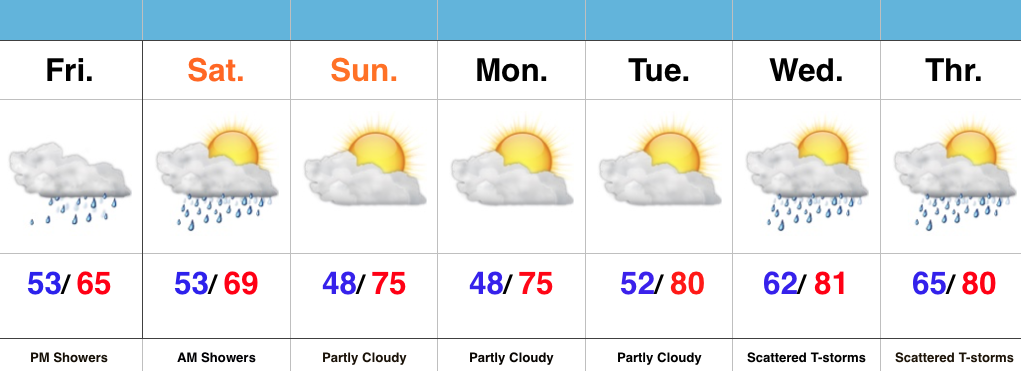
Rain Gear Needed This Afternoon…The Friday-Saturday forecast has been a headache all week as models have been “waffling” back and forth between heavy rains and mostly dry weather.  As it is, we’re actually going to end up “splitting the difference.”  While it’ll rain at times this afternoon into Saturday, totals will be relatively light (0.10″-0.30″ for most).

A brighter second half of the weekend is coming as sunshine returns Sunday.  That dry period of weather will carry us into the new work week, but we caution that wet and stormy weather will return by the middle of next week.  Expect a much warmer and more humid time of things next week.

Chilly, Blustery Weekend…

Screen Shot 2016-05-13 at 6.04.09 PMHighlights:

  • Band of showers and t-storms arrives late tonight
  • Very cool and blustery weekend
  • Drier pattern developing

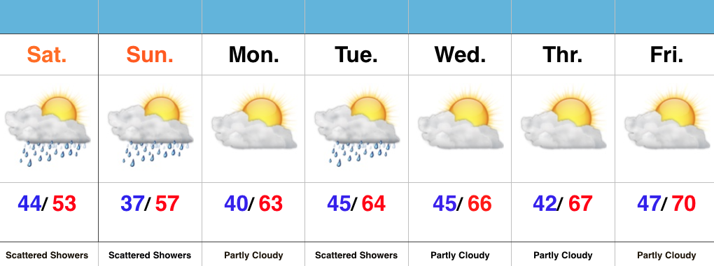
Unseasonably Chilly Weekend…A cold front is racing towards the region and will serve up a fresh batch of showers and thunderstorms overnight.  The bigger story will be a gusty NW wind shift and falling temperatures late tonight.  The chill will remain through the weekend with highs well below average and a patchy frost threat in outlying areas Sunday morning.  Most of Sunday will be dry, but a widely scattered shower is possible during the afternoon hours.

The majority of the upcoming work week looks much drier when compared to recent.  We’re watching a significant storm system, but general consensus of forecast model data at this point keeps the majority of significant rains to our south.  We’ll keep a close eye on things.  Slowly moderating temperatures can be expected as we progress through the week.

Scattered Strong Storms This Afternoon For Some…

Screen Shot 2016-05-12 at 7.28.35 AMHighlights:

  • Scattered Showers And Storms
  • Turning Much Cooler
  • Unsettled Early Next Week

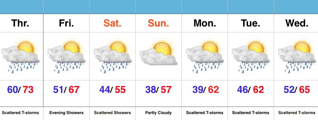
Have The Jackets Ready…The first of two cold fronts will sweep through the state this evening and help spark scattered strong to severe thunderstorms this afternoon and evening across mostly the eastern half of the state.  A secondary cold front will move through here Friday evening with showers Friday night into early Saturday.  It’s this second front that packs the much cooler air.  Jackets will be required this weekend, and scattered light showers will remain in our forecast Saturday.

As we push into the new work week, things appear to be rather unsettled (what’s new)?  An area of low pressure will push towards the region Tuesday into Wednesday and will increase rain and embedded storm chances.  It won’t rain the entire time, but we’ll want the rain gear handy.