
You must be logged in to view this content. Click Here to become a member of IndyWX.com for full access. Already a member of IndyWx.com All-Access? Log-in here.
Category: T-storms
Permanent link to this article: https://indywx.com/video-short-term-update-on-our-high-wind-event-fresh-december-ideas/
Oct 22
Plot Thickens Around Halloween Into Early November…
As we look ahead to Halloween, the pattern continues to look mighty “interesting” to say the least. A deeply negative EPO (East Pacific Oscillation) will take the drivers seat and potentially lead to some early wintry “fun and games” as we close out the month and head into early November.
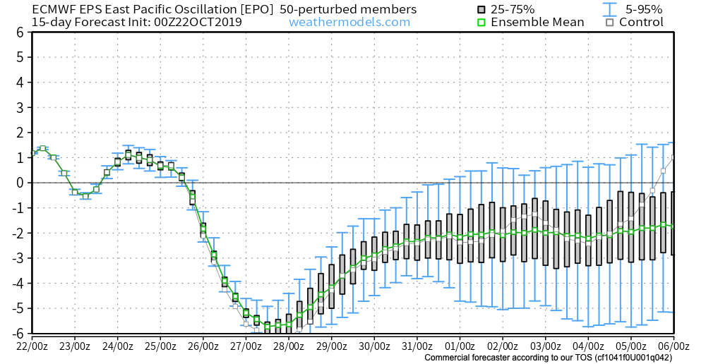
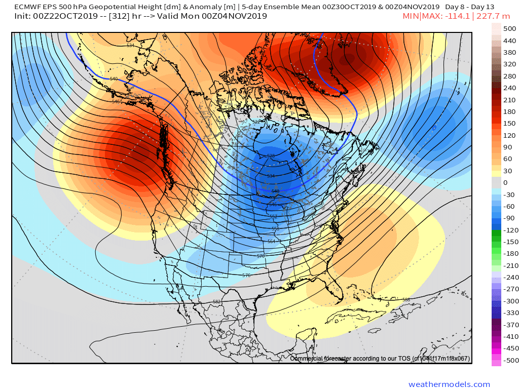
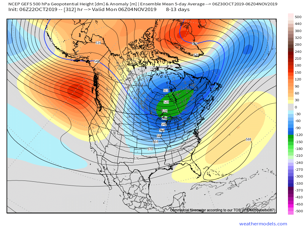
Ensemble data, centered on Halloween, is in excellent agreement with respect to the overall upper air pattern. That said there are subtle differences in the handling of the southeast ridge.


These seemingly subtle differences at 500mb can mean a world of difference in terms of the resulting weather we deal with here at the surface.
We’re confident there will be a rather significant weather event on or around Halloween, but caution we’re far from being able to provide details around the specifics. The early thinking is that a storm system provides a round of showers and thunderstorms just before the holiday with sharply colder conditions pouring into the area on Halloween, itself, with the threat of the first lake effect snow outbreak of the year heading into next weekend. Stay tuned. Run-to-run differences within the operational suites will be significant in the days ahead. It’s far too early to latch on to any one particular solution.
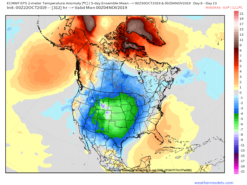
Regardless, with high latitude blocking in place, a colder than average period of weather is likely as we move through early November. The brunt of the cold, relative to normal, should be featured across the central Plains.
More on the longer range November pattern in the days ahead. Our official November Outlook will be posted over the weekend.
Permanent link to this article: https://indywx.com/plot-thickens-around-halloween-into-early-november/
Oct 21
VIDEO: Sifting Through The Noise As We Close October And Open November…
You must be logged in to view this content. Click Here to become a member of IndyWX.com for full access. Already a member of IndyWx.com All-Access? Log-in here.
Permanent link to this article: https://indywx.com/video-sifting-through-the-noise-as-we-close-october-and-open-november/
Oct 21
Wet, Windy, And Stormy Day Ahead…
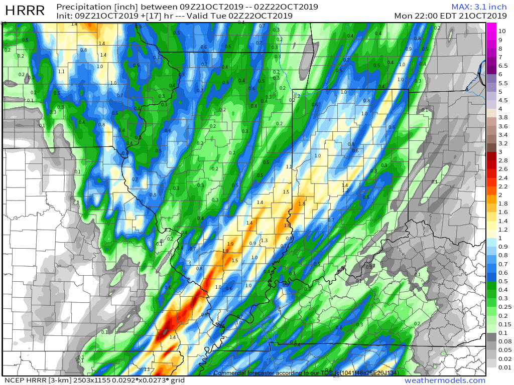
A cold front will push across the Ohio Valley today. Ahead of the front, widespread showers and thunderstorms are expected. A few of these storms may become strong to severe with damaging straight line winds being the biggest concern.
The Storm Prediction Center now includes portions of central Indiana in a ‘marginal’ risk for severe weather.
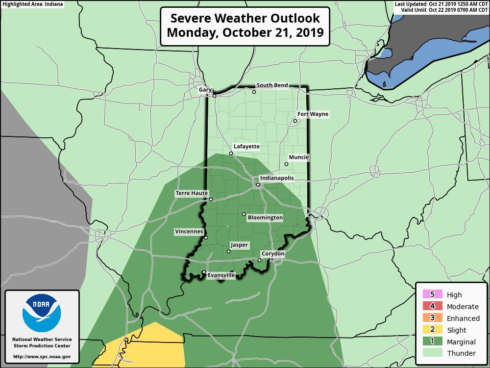
We expect a couple of rounds of storms today- one mid to late morning followed by another this evening directly ahead of the cold front.
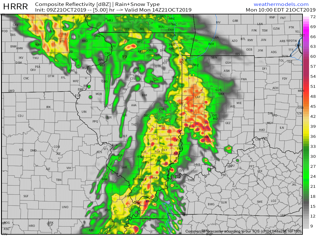
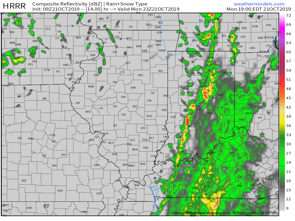
Rain will end from west to east during the evening as the cold front sweeps across the state. Before that, some area rain gauges may accumulate around an inch of rain today (a few locally heavier totals possible).
The other headline today will be strong and gusty winds (originally out of the southwest before shifting to west this evening). Even outside of thunderstorms, gusts in excess of 40 MPH can be expected.

Drier and cooler air will arrive Tuesday through Thursday before another chilly, wet weather maker blows into town Thursday evening into Friday.
Permanent link to this article: https://indywx.com/wet-windy-and-stormy-day-ahead/
Oct 19
VIDEO: Potential Shower This Evening? Looking Ahead To A Busy Week Of Weather…
You must be logged in to view this content. Click Here to become a member of IndyWX.com for full access. Already a member of IndyWx.com All-Access? Log-in here.
Permanent link to this article: https://indywx.com/video-potential-shower-this-evening-looking-ahead-to-a-busy-week-of-weather/