Pleasant Weather As We Close May…
Highlights:

  • Pleasant weather ahead
  • Storm chances return to close the week
  • Drier trend this weekend

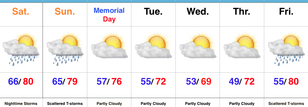
Happy Memorial DayBefore we look forward to the rest of the week, a secondary cold front will pass this evening and a couple of showers could bubble up as sunset nears.  These won’t be a big deal and should be quick movers with cooler, drier air building in overnight.  That will set the stage for a very pleasant midweek stretch, temperature-wise.  Another round of showers are possible Wednesday, but more dry time can be expected than wet.

More widespread showers and thunderstorms will return as we close the work week and open the weekend.  A cold front will push southeast Saturday morning and we’ll turn briefly warmer and more humid Friday with increasing thunderstorm chances during the back half of the day.  Once the front slides to our south, drier and cooler air will quickly return.  From this distance the weekend doesn’t look bad, at all.  Unseasonably cool, dry air will continue next week.

Upcoming 7-Day Precipitation Forecast:

  • Snowfall: 0.00″
  • Rainfall:  0.50″ – 1.00″

More Dry Time Than Not, But Keeping A Close Eye On Storm Chances…

Highlights:

  • Much more dry time than stormy
  • Timing storm chances
  • Unseasonably cool open to June

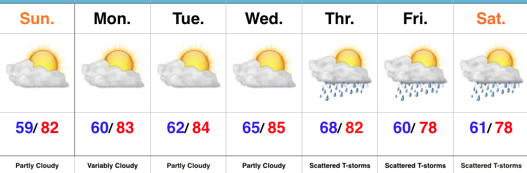
Best Storm Chances Arrive Overnight…Low clouds and areas of fog should dissipate and give way to partial sunshine as we progress into the late morning and afternoon hours.  A warm and humid feel will develop this afternoon.

The majority of the long race and holiday weekend will be free of any rain and storms, but we will continue to keep a close eye on the potential of more widespread storm activity:

Overnight tonight into early Sunday morning and again Sunday afternoon.

Data would place more emphasis on the potential of widespread severe weather across southern parts of the state tonight.  Damaging wind and hail are the primary concerns.  Additionally, as a cold front rumbles into the warm and moist airmass in place Sunday afternoon, additional strong to severe storms may develop.  These will be more scattered in nature when compared to the overnight round of storms, but any one particular neighborhood across central Indiana is fair game for getting wet for a brief time Sunday afternoon.

The cold front will sweep through the state Sunday evening and usher in a less humid and pleasant Memorial Day.  We’ll keep an eye on Tuesday into Wednesday for shower chances, but think we’ll remain mostly rain-free.  The region will be under a fast-paced northwest flow aloft and models can struggle with specifics associated with weak disturbances in that northwest flow.  The next chance of storms arrives Friday, along with a warmer feel.

Upcoming 7-Day Precipitation Forecast:

  • Snowfall: 0.00″
  • Rainfall: 1.00″ – 1.50″

Humidity Increases; Late Week Storms Then Cooler…

Highlights:

  • Sunshine and warmth continues
  • Increasingly muggy feel develops
  • Storm chances return
  • Much cooler next week

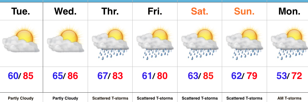
Very Warm And Increasingly Humid…High pressure will supply continued dry conditions, along with unseasonably warm temperatures through midweek.  A southwesterly air flow will help push an increasingly muggy feel into the region by Wednesday.  “Air you can wear” will be an appropriate way to sum things up!  🙂

That increasing moisture will eventually yield better coverage of showers and thunderstorms as we move through late week into the weekend.  It certainly won’t rain the entire time, but periods of scattered thunderstorms will be with us Thursday through Monday morning.  With high moisture content, locally heavy rains will be possible.

A cold front will move through the state Sunday night and Monday and result in a significantly cooler trend next week.

Upcoming 7-Day Precipitation Forecast:

  • Snowfall: 0.00″
  • Rainfall:  1.50″ – 2.00″

A Beautiful Mother’s Day; Summer-like Feel This Week…

Highlights:

  • Sun-filled weather
  • Trending warmer and more humid
  • Storm chances return late week

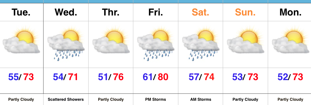
Happy Mother’s Day…High pressure will provide stellar weather conditions to celebrate mom outdoors today.  Look for plentiful sunshine, low humidity, and warm temperatures.  Enjoy the day!

Dry weather will continue through early week, along with progressively warmer conditions.  A southwesterly air flow will also develop and help pull increasingly moist air out of the Gulf of Mexico northbound.  It’s safe to say that humidity levels will grow into the “uncomfortable” category by midweek.

With that increasingly moist air mass in place and an approaching frontal system to our west, we’ll begin to increase scattered shower and thunderstorm chances by Thursday, continuing (in scattered fashion) into the weekend.

Upcoming 7-Day Precipitation Forecast:

  • Snowfall: 0.00″
  • Rainfall: 0.50″ – 1.00″