A Look Where We’ve Been And Where We’re Going…

September to date has been drier and warmer than average across the region- right as planned thus far, overall.       This morning featured a more aggressive push of showers…

You must be logged in to view this content. Click Here to become a member of IndyWX.com for full access.  Already a member of IndyWx.com All-Access?  Log-in here.

Dry And Warm Now; Cooler Times Over The Weekend…

Screen Shot 2015-09-15 at 9.51.31 PMHighlights:

  • Dry times continue
  • Front comes through mostly dry
  • Weekend cooling

High pressure will remain in control into the latter portion of the work week before giving way to an approaching cold front late Friday.  Dry conditions will continue before we introduce showers into the picture late Friday night into early Saturday.  Unfortunately this doesn’t appear to be a significant rain maker, but we’ll take what we can get.  The bigger story will be the push of much cooler air that arrives Saturday evening into Sunday.

Upcoming 7-Day Rainfall Forecast: 0.10″ – 0.25″

Labor Day Weather Notebook…

September Scorcher: September has gotten off on a downright hot note.     While we have a couple more days of highs that will push 90°, changes are brewing that will…

You must be logged in to view this content. Click Here to become a member of IndyWX.com for full access.  Already a member of IndyWx.com All-Access?  Log-in here.

Hot With Isolated Storms…

Screen Shot 2015-09-03 at 7.55.33 AMHighlights:

  • Hot and humid conditions continue
  • Isolated storm coverage
  • Cold front approaches next week

In the short term, heat and humidity remain the big weather story as we head into the long Labor Day weekend, and unofficial end of summer.  BTW- meteorological summer ended Monday evening; however someone forgot to tell Mother Nature.  Isolated storm coverage will be present into the weekend.

The next big weather maker is on the horizon by the middle of next week in the form of a cold front.  Much better chances of more widespread showers and thunderstorms should precede the front before a much cooler air mass arrives late next week.

Upcoming 7-Day Rainfall Forecast: 0.50″ – 1″

Summer Isn’t Letting Go…

Screen Shot 2015-09-01 at 9.42.32 PMHighlights:

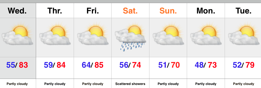
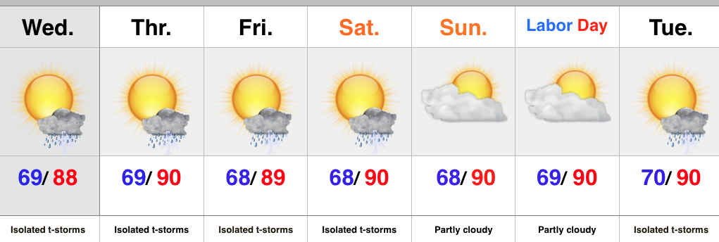
  • Isolated slow moving storms
  • Hot and humid air mass remains
  • Stagnant pattern

An upper level disturbance will push slowly east into Ohio Wednesday, but will remain close enough to have some impact on our local weather.  Coverage of storms won’t be as widespread as those of today, but we’ll likely see a few slow moving, strong storms develop across central IN all the same.

We’ll maintain mention of isolated storms into the weekend, but the big weather story will be the unseasonably hot and humid air mass in place.  It’s all part of the big weather picture that includes a strengthening high pressure ridge (hot dome) over the Lakes and SE Canada as we rumble into the long holiday weekend.

Looking ahead, there are indications that more active times are around the corner once to mid month.

Upcoming 7-Day Rainfall Forecast: 0.25″ – 0.50″ (locally heavier totals)

Storms rumbled across portions of central IN today, but the “@cryptics cam” caught a glorious sunset from Danville this evening.