New Thoughts Around The Upcoming Winter…

While we’re still a couple months away from debuting our official annual Winter Outlook, we’re deep in research mode for what the ’19-’20 winter season may produce across central Indiana.

The very warm northeast Pacific sea surface temperatures are of the upmost interest.

Note how the northeast PAC waters continue to warm:

These warm waters continue to “raise an eyebrow” and will have likely have a rather significant say in what ultimately takes place later this winter across a widespread portion of the country.

We don’t have to think too terribly far back to the infamous ’13-’14 winter and what the “warm blob” produced:

Image courtesy of iflscience.com

Some of the new climate models are going to a similar look at 500mb for the upcoming winter season:

In fact, one could easily make the argument with such anomalous ridgBing across western Canada, there should be more of a downstream effect (more of a significant trough across the eastern portion of the country).

While there will be many more factors that we’ll have to build into the upcoming winter outlook, the warm NE PAC waters most certainly argue (and strongly at that) for a rather persistent western Canada/ NW Conus ridge and more of an eastern trough…

Dinnertime Rambles: Quiet Through The Short-Term And Longer Range Musings…

I. Drier air continues to surge south and with it will come much cooler temperatures overnight into Tuesday morning. We still believe most central Indiana reporting sites will fall into the middle 50s Tuesday morning. Turn off that A/C and open up those windows!

II. Weak upper level energy will push south and lead to isolated to widely scattered instability-driven showers across northern parts of the state tomorrow afternoon. A couple of these quick-moving showers could scoot into central Indiana, but we continue to believe most will remain free of any precipitation tomorrow.

III. Overall, we’re looking at a very quiet weather pattern through the weekend with an extended period of dry weather, thanks to high pressure. Temperatures will slowly warm from the unseasonably cool and refreshing levels into mid week to more of a seasonal feel this weekend.

IV. As we look ahead, the upper air pattern should transition to more of a classic summer-like regime to open August. However, data shows the ridge continuing to “retrograde” west with time, resulting in a period of wetter conditions with a northwest flow aloft Days 10-15 (roughly Aug 2nd- Aug 7th). It’s always good to see agreement between the European and GFS ensemble products below.

V. Research continues on the upcoming fall and winter and it’s becoming increasingly difficult to ignore the warm sea-surface temperatures across the northeastern Pacific. Interestingly, most seasonal model data maintains this warm “blob” into the late fall and early winter. Note where we are currently (center photo) vs. where the projection off the UKMET (top left) for Oct-Dec and European (bottom left) for Nov-Jan.

While only 1 of several ingredients used in building our seasonal outlooks, this can promote the tendency for more persistent western ridging and downstream trough (associated colder pattern) across the East…

Early August Ideas…

The year continues to fly by! We’re now finalizing our forecast for the last month of meteorological summer and will include a look-ahead to our early fall ideas with the official August Outlook that hits the site later next week. With that said, here are some of our early August ideas:

I. Sea surface temperatures remain well above average through the western Atlantic basin as well as the northeastern Pacific. This should promote warmer than normal conditions, overall, along the coastal areas. Additionally, we’ll need to continue to keep a close eye on the potential of additional “home grown” (Gulf of Mexico and off the southeast US coast) tropical development as we move closer to the peak of the hurricane season.

II. The MJO isn’t nearly as hyper as months past. While we’ll continue to keep a close eye on things, we currently don’t anticipate being able to lean on this tool as a good indicator for what may transpire through the month of August (at least early on).

III. We need to keep a very close eye on the EPO over the upcoming week to see if modeling continues to project a significantly negative phase into August. This can “up the ante” for a cooler than normal central US during August if so.

IV. Lack of widespread drought/ dryness. The wet spring and early summer really can help make an impact longer term and that has been seen as early as this week (added humidity with the heat wave), but also helps overall when it comes to late summer and the respect to the staying power, or longevity, of heat waves.

Here’s our early thinking with respect to August temperatures and precipitation. Again, our final, more detailed, outlook will be issued next week!

2019 IndyWx.com Summer Outlook

2019 is absolutely flying by! Before you know it, we’ll be releasing our 2019-2020 Winter Outlook. Kidding- sort of. 😉

Is a blazing hot summer in store for central Indiana, or perhaps wet and cool? Let’s dig in to the details…

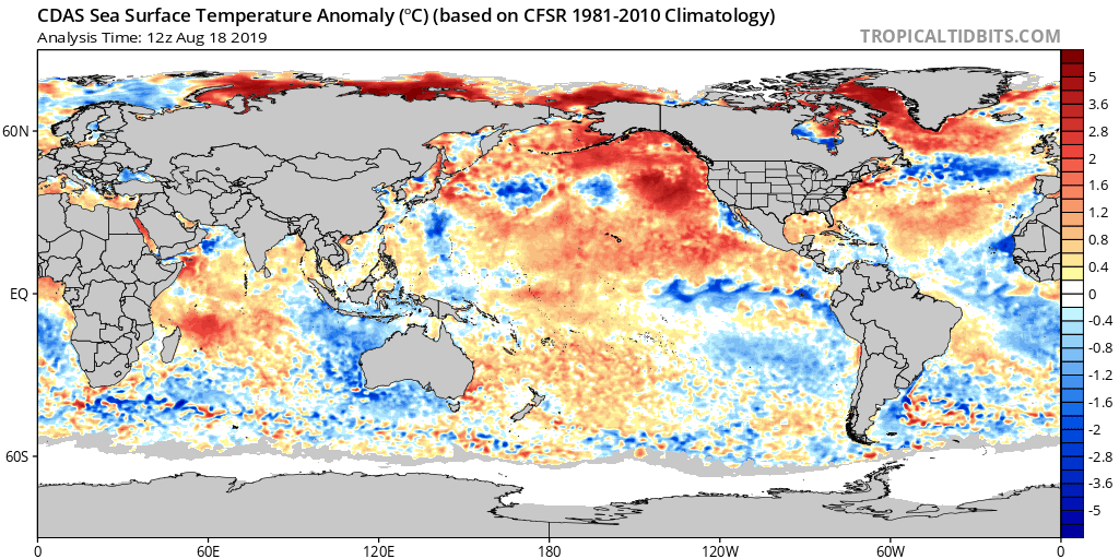
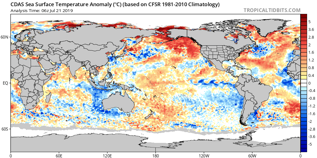
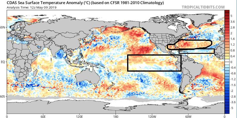
As we look at current sea surface temperature anomalies, a few items stand out:

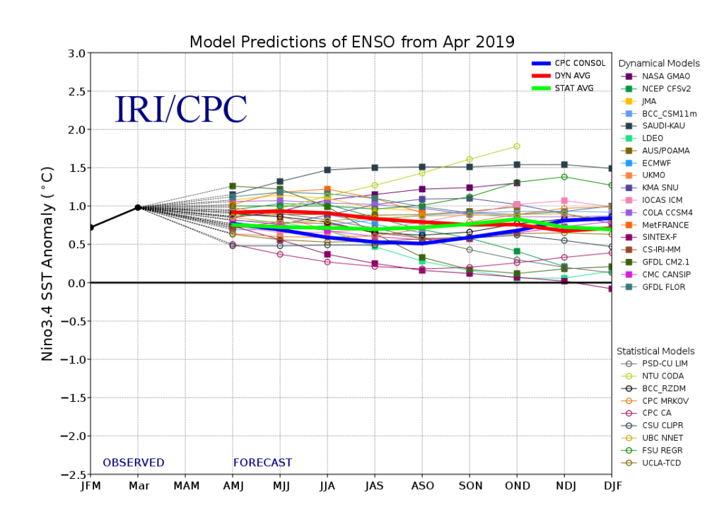
I. We expect a weak El Nino to continue through meteorological summer (June through August), and perhaps even into next winter.

II. MDR (Main Development Region for tropical entities) is running cooler than normal and would suggest an overall “less busy” hurricane season from a long-track perspective

III. SSTs are running much warmer than normal in the Gulf of Mexico and off the East Coast. This is important as while the long-track tropical systems may not be as frequent, we’ll have to remain on guard for the potential of active times closer to home this season. Additionally, these warmer anomalies tend to lead us to believe precipitation will run above normal across coastal areas into the Deep South this summer.

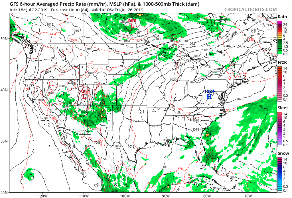
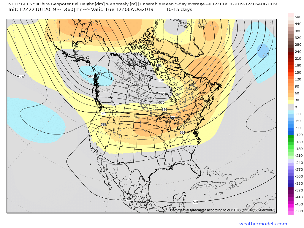
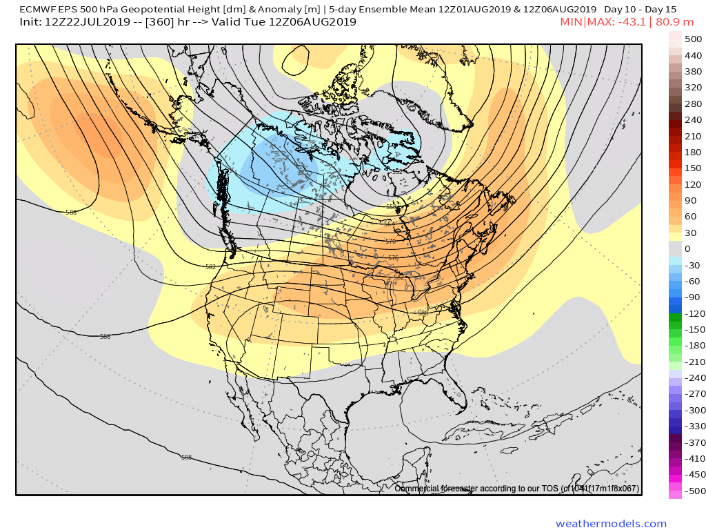
Let’s look at some of the climate computer model data for the summer season:

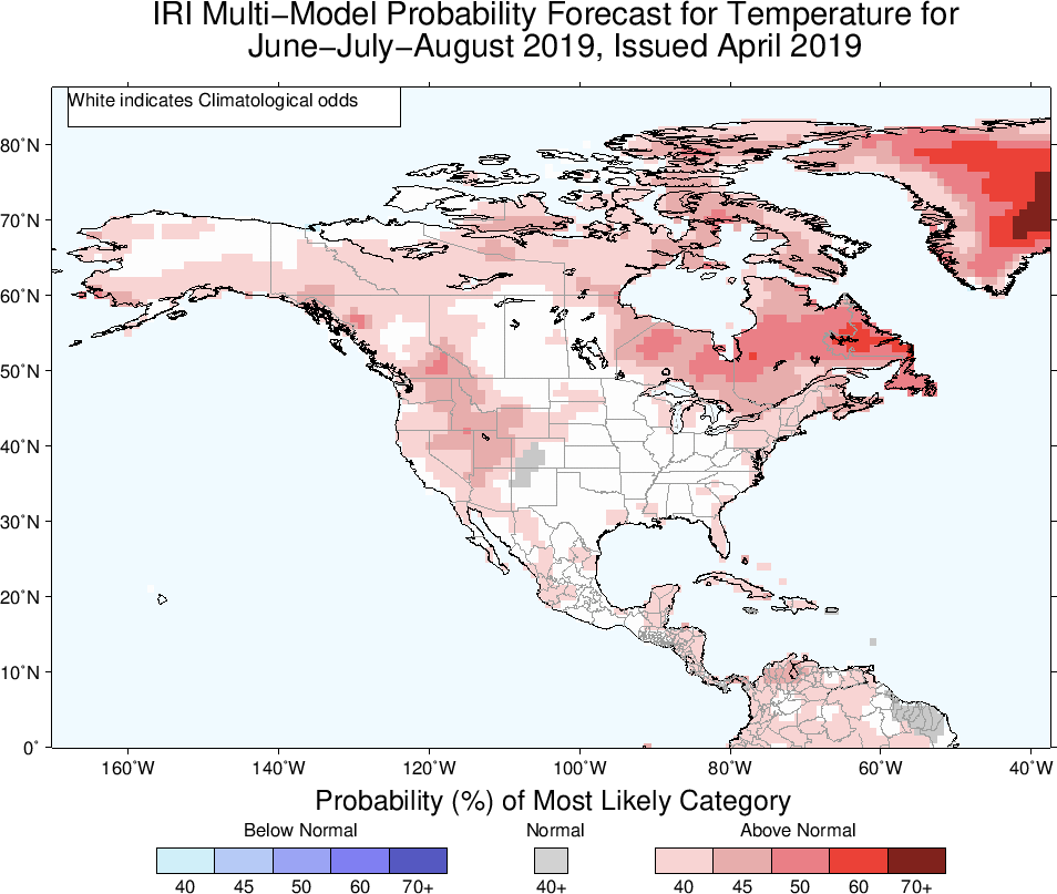
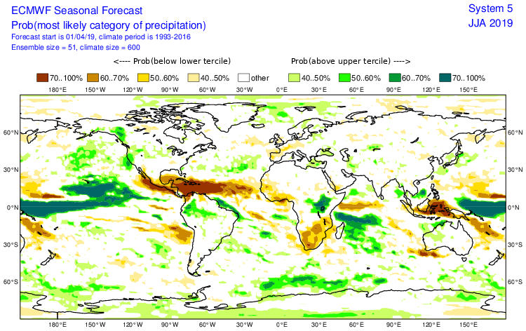
The latest IRI model (International Research Institute) shows relative warmth along the coastal areas and the west with greatest wet anomalies across the Northwest.

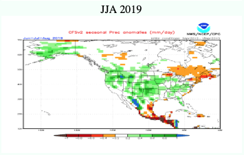
The CFSv2 is leaning towards an anomalously wet summer across a widespread portion of the country (exception being New England).

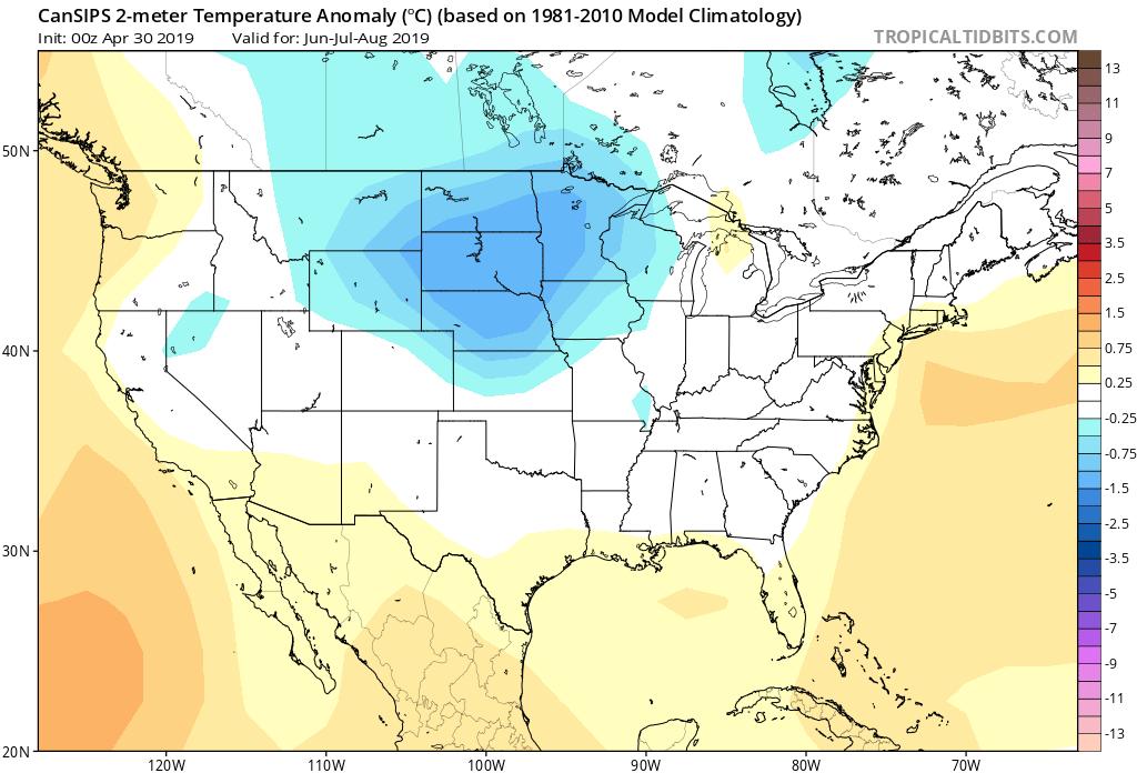
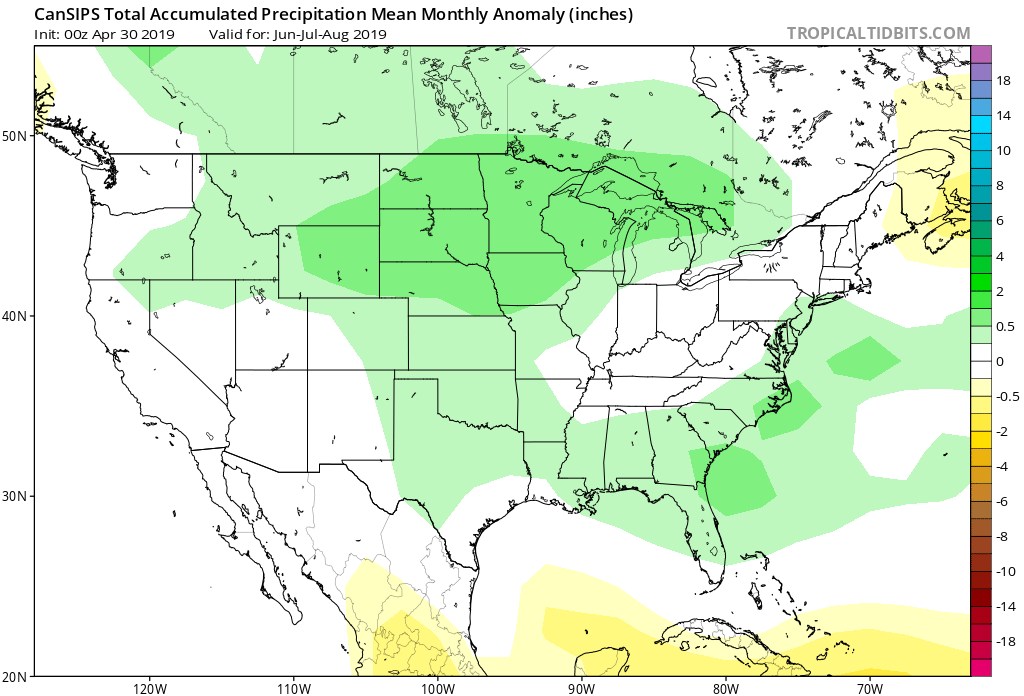
As we review the CanSIPS, it likes the idea of a cool, wet summer across the Heartland with warmth along the coasts.

The European Seasonal Forecast has a seasonal summer for most of the country with warmth along the coasts, and a reflection of wetter anomalies across the northern Plain into the Northwest.

(The JMA Seasonal hadn’t updated as of this post).

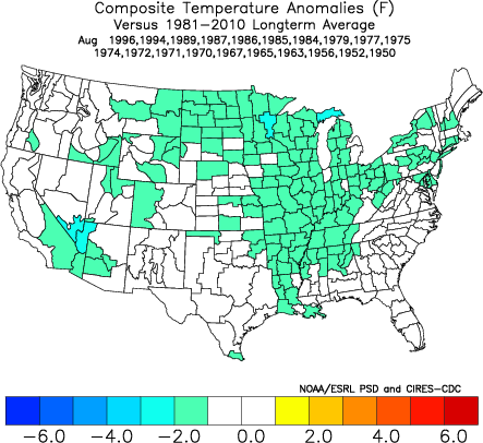
After taking into account the various seasonal model data above (which is in remarkable overall agreement for a LR forecast idea), along with the current SST configuration, and analog data, this is how we see the Summer of 2019 playing out.

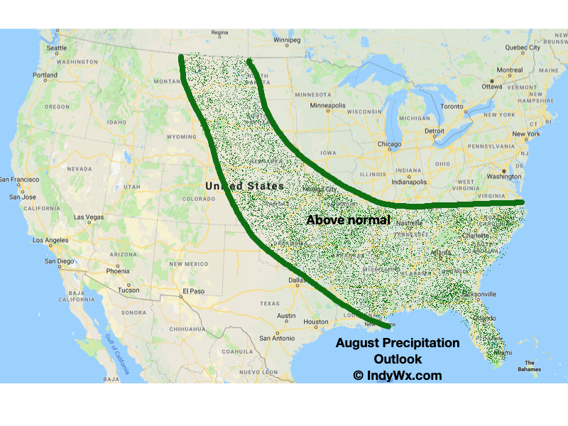
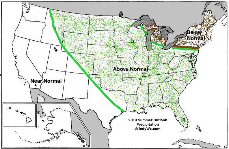
Specific to central Indiana, we’re forecasting a rather wet and cooler than average summer. Frequent storm systems should keep things active around these parts for the balance of the summer season, with the temperature scale tipping a touch cooler than normal.

While the number of named storms should be down compared to normal (highlighted by the Euro seasonal precipitation idea), we’ll have to keep close tabs on the Gulf of Mexico and off the Southeast coast for the potential of “last minute” development. Those warmer than normal sea surface temperatures lurking off the coast does warrant concern for at least the threat of another active year from a landfall perspective.

Strong Storms Thursday Night; Early Summer Ideas…

The daytime Thursday will be dominated by a summer-like feel as highs approach the 80 degree mark, along with an increasingly gusty SW wind ahead of an approaching cold front. We’ll stay dry through the day and it’s not until we get to the overnight hours when storm chances will begin to increase.

More specifically, we think the hours between 12a and 5a will offer up the best chance of a slow moving line of storms to track across central Indiana. A couple of these storms could produce damaging winds. Locally heavy rainfall can also be expected with widespread amounts of 0.50″ to 1″ with a few 1″+ totals likely by the time we get to sunrise Friday. The rain will be well to our east by lunchtime Friday and a dry close to the day is on tap.

On the heels of this storm will come another wet weather maker Saturday night and Sunday and tomorrow morning’s video update will have more details around timing and rainfall amounts with that system.

Early Summer Ideas

I. Weak El Nino anticipated to persist through the Summer of 2019.

II. Warm SSTs in the Gulf of Mexico and off the Southeast Coast.

We’ll have our complete official Summer Outlook posted during the first week of May, but wanted to share our early thoughts. Overall, a warmer than average summer is expected with average to slightly above normal rainfall, locally.

The warmer than average sea surface temperatures (SSTs) raise concern for the potential of well above average precipitation across the Southeast and MidAtlantic regions. Additionally, those warm water conditions also mean we’ll need to keep close eyes on the potential of tropical activity early on in the season in the Gulf or off the SE coastline.

Much more next month, including graphics!

Talk with you bright and early in the AM!