Catching Up On A Tuesday Evening And Looking Ahead…

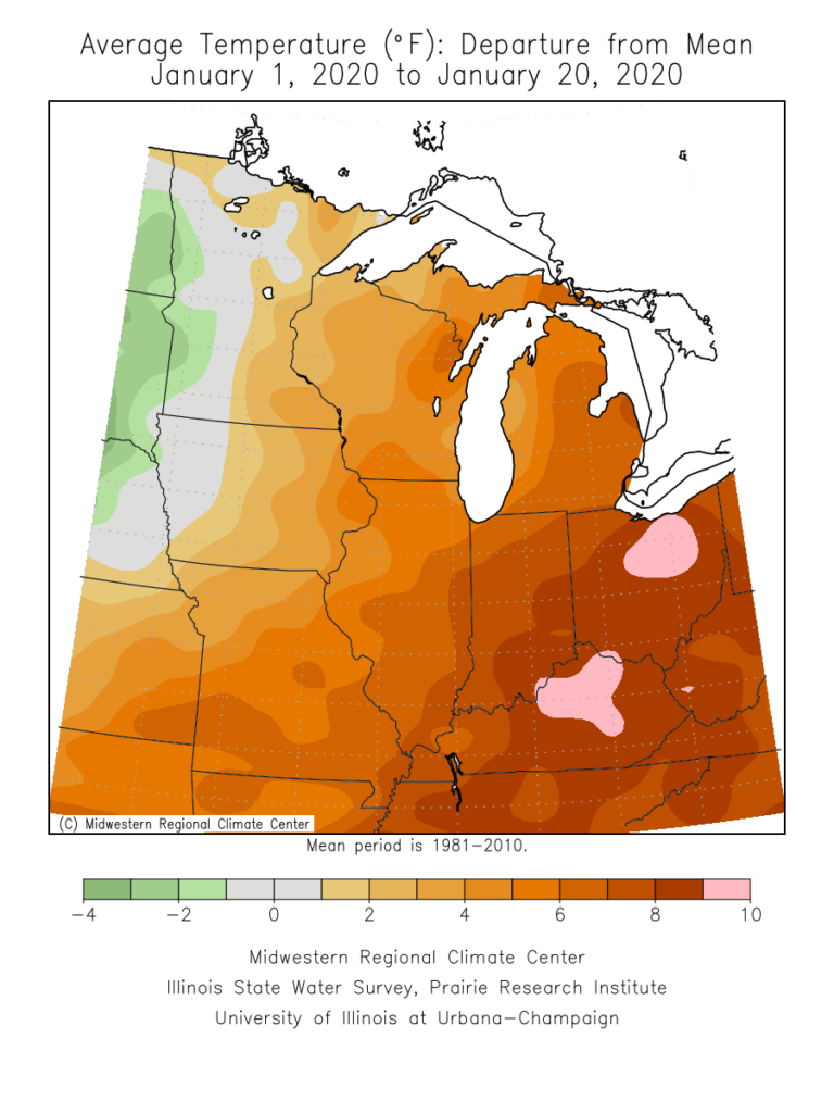
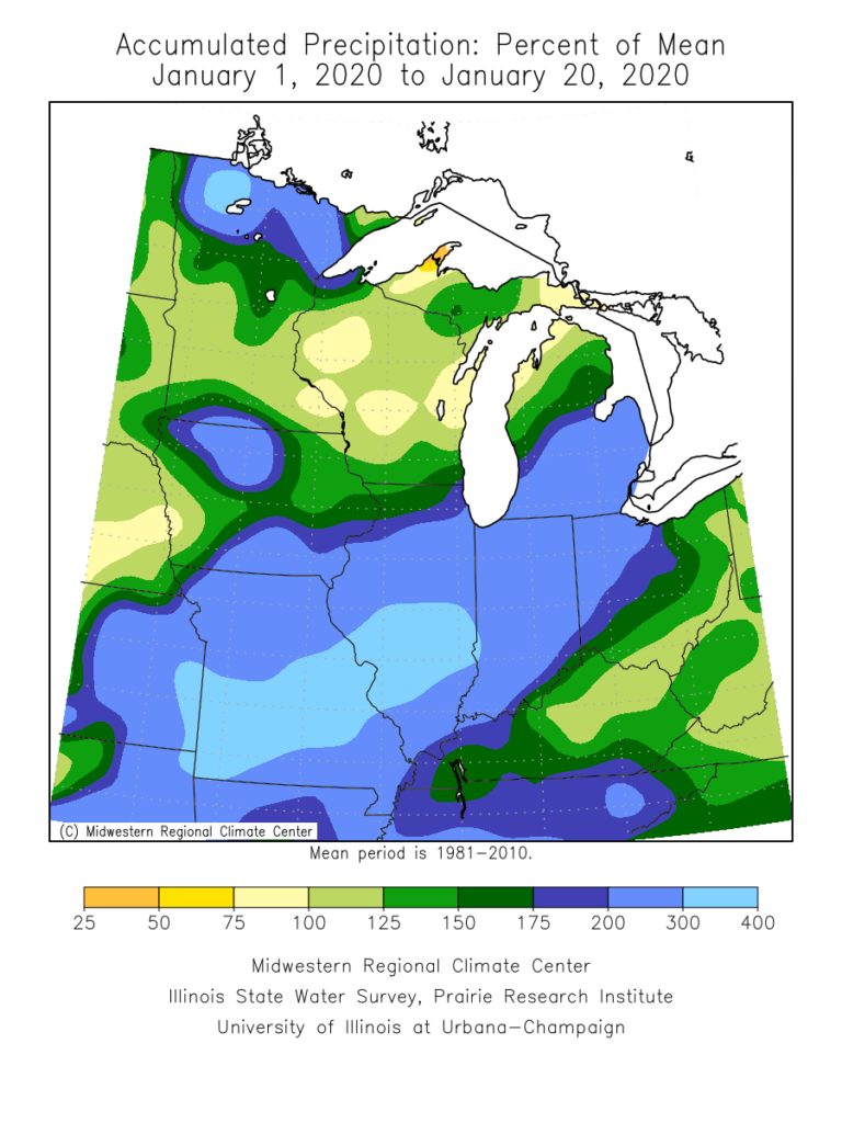
January is flying by! With only 10 days left in the month, Indianapolis is running a whopping 8.2° above normal along with more than 3″ above normal in the precipitation department (unfortunately for snow lovers, this excess moisture has fallen primarily as rain, as IND is running a deficit of 5.2″ in the snowfall department).

January month-to-date temperature anomalies, courtesy of the Midwestern Regional Climate Center
January month-to-date precipitation anomalies, courtesy of the Midwestern Regional Climate Center

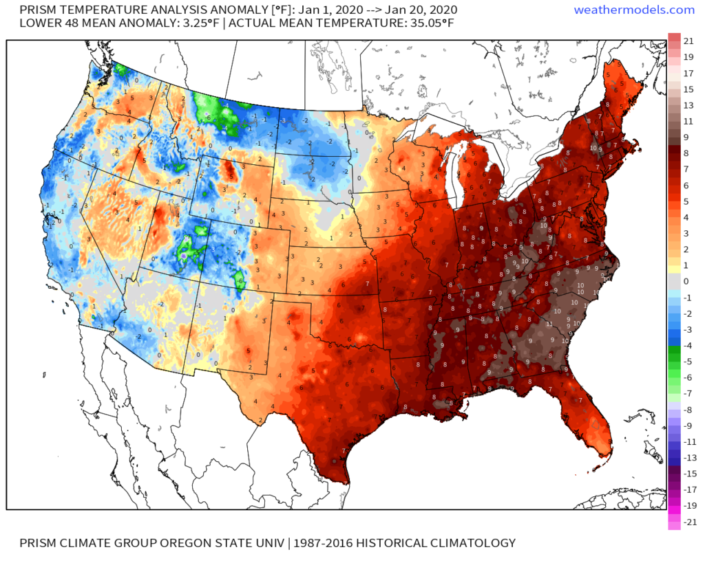
On a broader scale, here’s a look at the current month-to-date temperature anomalies for the Lower 48 as a whole:

January Lower 48 month-to-date ‘mean’ temperature anomalies, courtesy of weathermodels.com

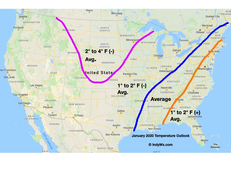
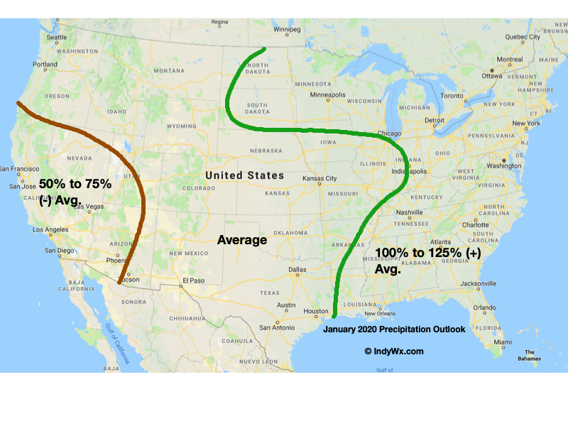
As a refresher, our January forecast looked like this:

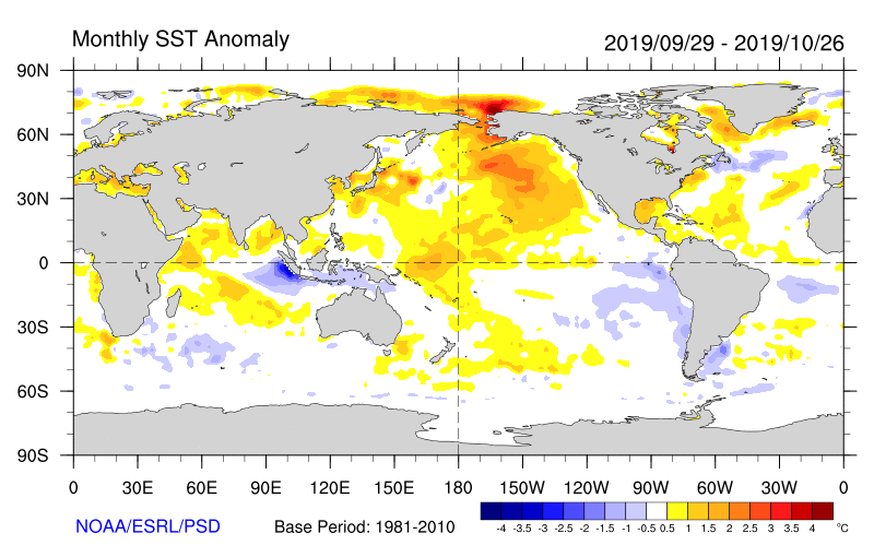
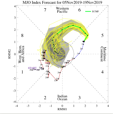
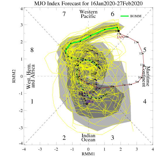
The baseline of this thinking had to do with the idea we had that the MJO would roll out of the warm phases (5 and 6) and strongly into the colder phases after mid-month. Secondly, the other driver was the thought that the current SST configuration in the north Pacific would “force” a negative EPO as the winter season matured.

While the MJO did, indeed, rumble out of the warmer phases just after mid-month, the EPO has not cooperated. Furthermore, instead of the MJO tracking into Phases 8, 1, and 2, it appears it wants to go into the “null” phase to figure out its ultimate destination for the 2nd half of winter (this will be key with Feb. and March). While this doesn’t necessarily support warmth, it doesn’t offer enough ammo to fight the warm signal from the strongly positive EPO.

Now that we’re beginning to turn the page to the 2nd half of winter, there are other items to begin paying closer attention to. In addition to the EPO and MJO, some of these features include the AO, NAO, and PNA. With that said, to drive more of a consistent colder than normal theme, we need to get the EPO at least into the neutral range as some of the other ingredients noted above transition into more favorable colder phases. With a strongly positive EPO, it’ll be tough to sustain well below average temperatures.

With all of that said, all hope is not lost for winter lovers. Climatology speaking, we’re in the coldest time of the year. Even in “marginally” cold patterns, or even “warm” patterns this time of year, wintry issues can create headaches. Secondly, it’s worth paying close attention to the MJO over the next couple of weeks as some of the data wants to take things out of the null phase and transition towards the traditionally colder phases of 8, 1, 2, and 3.

As it is, the next couple of weeks should present a fairly active storm track across the region. In the face of what should truly be a “torch” pattern, the saving grace (at least for fans of winter weather) has to do with the strong Hudson Bay ridge and tendency this kind of pattern has to force stormy times underneath. While far from a “slam dunk,” these kind of patterns can produce- even in the face of a strong positive EPO.

If you had to choose, would you rather have a bitterly cold and dry regime or seasonably mild with at least being on the playing field for wintry mischief over the next couple of weeks?

More in the AM, friends. Make it a relaxing evening! 🙂

Important To Know What Lever To Pull And When…

As another year comes to a close and the winter pattern begins to “mature,” we thought we’d do a little rambling…

This evening’s rambles have to do with the variety of “drivers” that at times like to take control of our weather pattern. You hear us use terms like the MJO, EPO, AO, PNA, and NAO (amongst others) often, but at times, these various pattern drivers can have more impact than others, and at varied times of the year.

Traditionally, if the MJO (Madden Julian Oscillation) is highly amplified, that’s going to serve as the basis of our medium or longer range forecasts. However, if the MJO is in the null phase, other teleconnections can take control of the wheel. Sea-surface temperature configuration can give hints to the way these elements may behave during the season(s) ahead, but we caution each respective season takes on a flavor unique to it’s own. That’s what makes this business so fun, challenging, and, at times, frustrating. 🙂

It’s also important to understand when the ingredients noted above have the greatest impact on our immediate weather. We love to lean more heavily towards the NAO and AO mid-to-late winter into the spring, for instance. Case in point, a negative EPO and positive PNA can quickly trump a positive AO/ NAO this time of year, and vice-versa.

In the event you didn’t have a chance to see it Sunday, we released our January Outlook. We have a very stormy month outlined that includes cold “overwhelming” things as the month progresses. A lot of this has to do with the fact we think we see a “shake-up” with the MJO out of the warm phases and into the traditional cold phases of 8,1, and 2 taking shape during the 2nd half of the month. Additionally, we continue to believe the favorable north Pacific sea surface temperature configuration (for a cold Great Lakes and OHV) will begin to force the negative EPO/ positive PNA.

The NEW European Weeklies show the transitional time of things through the 1st half of the month, but note the building more persistent NW NA ridge during the 2nd half of the month and corresponding reflection of an eastern trough. Should the MJO be heading into Phase 8 around this time frame (and we think it will), this trough will likely correct stronger in future updates for late month.

The model sees the stormy time of things through the month and into February. (Important to note that even “warm” months this time of year can also feature above normal snow. Just see this December- nearly an inch above normal for the month). As things stand now, we see multiple opportunities for snow as January gets underway, including Saturday PM, and again Tuesday night into Wednesday.

Make it a great evening! We’ll be back early in the morning with a fresh video update.

January-Like Cold Inbound Next Week; What Awaits Thereafter?

“Normals” for January includes highs in the middle 30s and lows in the upper 10s to lower 20s across central Indiana. Early to middle parts of next week are forecast to feature highs in the upper 20s to around 30 and lows in the middle 10s. Yes, these temperatures will challenge records as a truly impressive arctic invasion claims next week’s weather headlines.

Record cold is ahead next week.

A lot of this has to do with the sea surface temperature (SST) configuration across the northern Pacific. We’ve been focusing in on the warmer anomalies across the north and northeastern Pacific and tendency for this to drive a persistent ridge across NW NA since late summer. That persistent NW NA ridge leads to a persistent trough downstream and the associated cold pattern we’re now looking at. As our Winter Outlook suggests, we think this overall pattern repeats itself throughout the majority of the months ahead.

As we look more “immediate term,” what do teleconnections and the MJO tell us about the overall pattern moving past the middle of November? Well, to start, the highly amplified MJO is forecast to roll into Phase 7 around mid-month. This suggests the colder than normal pattern persists.

The EPO is forecast to remain negative while the PNA remains positive into and through the mid month period. Both argue for continued cold.

To no surprise, the latest long range data continues to drill unseasonably cold air south into our portion of the country and a large majority of the eastern portion of the Lower 48 in the Weeks 2-3 time period. Snow opportunities will undoubtedly follow with this kind of pattern.

Buckle up…

Evening Video: A Tale Of Extended Summer That Gives Way To Sudden Winter…

You must be logged in to view this content. Click Here to become a member of IndyWX.com for full access.  Already a member of IndyWx.com All-Access?  Log-in here.

Something Doesn’t Jive…

I want to give a couple examples of significant conflicting signals- both short and long-term. The end result is a situation where long range, climate, and seasonal models are likely to have a very tough time not only in the medium to long range (2-4 week period), but thinking seasonally, as well (winter and next spring).

Short-term

To start, let’s look at the EPO. While strongly positive at present, both the EPS and GEFS pictured below take the EPO, or East Pacific Oscillation, negative in the coming couple of weeks.

A negative EPO pattern favors a trough across the eastern portion of the country, especially here in our neck of the woods, with western ridging.

All well and good, right? WRONG. The MJO, or Madden Julian Oscillation, is forecast to stall out into early October in Phase 1.

This time of year, Phase 1 argues strongly for eastern ridging and well above normal warmth while the western portion of the country can experience early wintry conditions.

Talk about contradiction! That’s what makes weather so fun and fascinating. Expect to be humbled often and to always learn! At various times of the year, select teleconnections can mean a lot more than other times of the year. For example, during the summer and fall, we lean heavily on the EPO, PNA, and MJO (if amplified). During the winter and spring, it’s important to take into account what the AO and NAO have to say. It’s important to know when to “pick and choose” when to use particular teleconnections… Furthermore, the various MJO phases (1-8) mean drastically different things at different times of the year. While lovers of chilly fall conditions have grown to hate an amplified Phase 1, they have to love it come winter (shown below). Just look at that difference!

Before jumping ahead to another example of “contradicting signals,” we’re confident the amplified MJO Phase 1 will carry the day through the short to medium range period. Note the strong agreement between the EPS and GEFS below with respect to temperature anomalies in the 6-10 day period.

With that said, there will be challenges within (the big difference as early as this weekend between the GFS and European operational data). A lot of that has to do with the “fight” between the EPO and MJO to take control.

As all of this unfolds across the East, the west will begin to cash in on early winter. Well below average cold and snowy conditions will begin to make headlines over the weekend into next week across not only the Rockies, but some of the low ground, as well. Should the MJO swing into Phase 2 (and I think it will towards mid-Oct), then watch out. We’ll be looking at a rather significant shift towards a much colder feel- and it’ll sting even more so with the late season heat over the better part of the next couple of weeks.

Flipping the page to winter (remember, our prelim. winter outlook will be posted later this week) and the contradiction continues. Upon looking at the current SST configuration, one could easily argue we’re talking about a La Nina winter unfolding ahead.

Meanwhile, the current SOI would suggest we’re in a moderate El Nino.

If you think this can’t wreck havoc even on the short-term forecast pattern, think again…

To close, while the conflicting data can create headaches at times, it’s more fascinating than ever trying to sift through the data and build our forecast(s). It’d be wise to expect more wild swings ahead- leave it to us to try and minimize the impacts of those swings in your day-to-day personal and professional lives. Accordingly, it’s also ultra-important to factor in additional items, such as solar and PDO into the equation for the upcoming winter.

Speaking of, without giving too much away, if I’m a winter weather fan (and I am), I wouldn’t worry in the least about the current warmth… 😉