
You must be logged in to view this content. Click Here to become a member of IndyWX.com for full access. Already a member of IndyWx.com All-Access? Log-in here.
Category: Spring
Permanent link to this article: https://indywx.com/video-stormy-wednesday-evening-for-some-weekend-flood-threat/
Apr 25
Weekend Heavy Rain Threat…
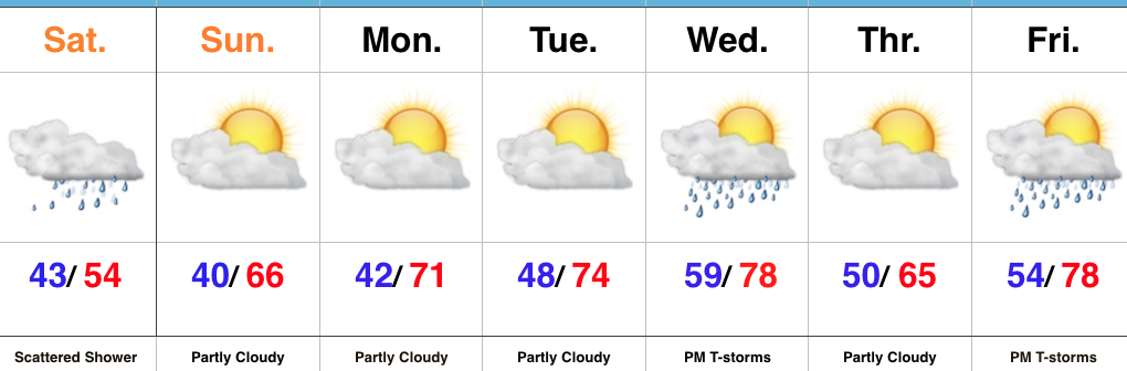
We still have a few nice days to enjoy this week before our forecast takes an increasingly wet shift as we progress through the weekend. As a side note, we still expect scattered showers and thunderstorms late Wednesday night into Thursday morning, but this shouldn’t be a significant event, locally.
What will become an increasing concern is the threat of periods of heavy rain and thunderstorms this weekend. The overall setup is a classic one for widespread heavy rain.
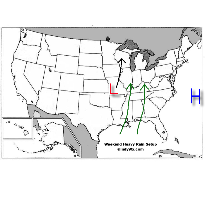 An area of high pressure will be located off the Mid Atlantic coast while surface low pressure develops in the southern Plains and tracks north over the weekend. The combination of these two ingredients will help pull abundant Gulf of Mexico moisture northward into the Ohio Valley. With a true Gulf connection, moisture-rich air will overspread the region this weekend. In addition to feeling truly muggy for the first time this year, this will also aid in periods of heavy rain this weekend.
Precipitable water values will approach 2″ at times this weekend and that’s plenty enough to create a localized flash flood concern.
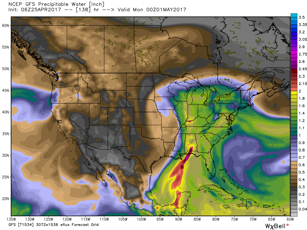 From this distance, it appears like widespread 2″ to 3″ of rain will fall over the weekend, but localized heavier totals are expected where thunderstorms “train” over the same areas. While it won’t rain the entire weekend, times of wet weather will outnumber dry hours and if you live near a creek or stream, keep abreast of this developing weather situation as significant water rise is expected over the weekend.
Permanent link to this article: https://indywx.com/weekend-heavy-rain-threat/
Apr 23
Quiet Open To The Work Week Turns Stormy By Midweek…
After a blustery and chilly Saturday (and temperatures in the upper 30s to start our Sunday), a gorgeous close to the weekend is ahead. Wall-to-wall sunshine is expected with moderating temperatures this afternoon. Our average high on the 23rd of April is 66° and we should be very close to that later this afternoon. Enjoy!
High pressure will remain entrenched over our area as we progress through the early portions of the work week. This will provide pleasant weather and plentiful sunshine. With a dry airmass in place, expect significant temperature swings. Overnight lows in the 40s will quickly rise into the 70s Monday and Tuesday.

High pressure will dominate our early-week weather.
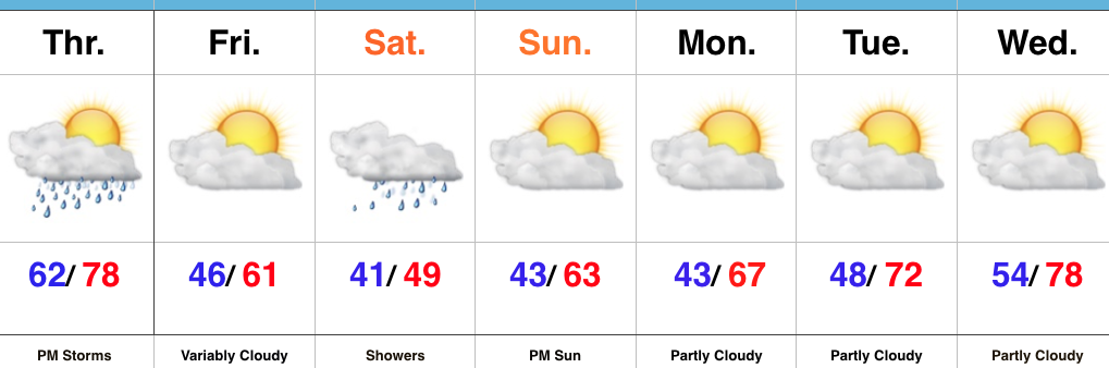
A southerly flow will help pull a more humid air mass northward Wednesday and as a cold front slices into the unseasonably warm and muggy airmass, we expect showers and thunderstorms to increase Wednesday evening into Thursday morning. We still have some time to watch things evolve, but from this distance, we feel strong to severe thunderstorm potential is present during this period. Locally heavy rains are also possible as PWATs zoom to 1.5″ +.
Precipitable water values will increase to 1.5″+ Wednesday and support the threat of locally heavy rain.
We’ll get into some briefly drier air to wrap up the work week, but a warm front will blow through the region Saturday and will likely be accompanied by thunderstorms as it lifts north. Once the warm front passes, unseasonably warm and humid air will make a return and set the stage for a true summer-like feel next weekend. We expect highs to go into the lower to middle 80s with a muggy feel, as well.

 Finally, after Saturday morning thunder, we think the majority of next weekend is dry before a cold front brings a return to widespread showers and thunderstorms late Sunday.

Permanent link to this article: https://indywx.com/quiet-open-to-the-work-week-turns-stormy-by-midweek/
Apr 22
Chilly Saturday Gives Way To Improving Weather Sunday…
 Highlights:
- Showers south today
- Unseasonably cool and blustery
- Increasing sunshine Sunday
- Midweek storms
Jackets Required Today, But Improving Weather Tomorrow…A stiff northeast wind is “eating away” at the northern extent of rain today. Steadiest rains will fall across the southern third of the state, but a couple of showers may make it as far north as Indianapolis later this afternoon. The bigger story will easily be the brisk northeast flow and unseasonably chilly air. In fact, we’re waking up to wind chills in the 30s this morning. Jackets are required today.
Drier air arrives on the scene tonight and clouds will decrease overnight, paving way for a beautiful Sunday. Expect plentiful sunshine and moderating temperatures. Dry and pleasant weather continues into midweek before an approaching cold front delivers our next chance of thunderstorms Wednesday evening.
Another fast-moving weather maker will deliver thunderstorm chances to close the work week.
Upcoming 7-Day Precipitation Forecast:
- Snowfall: 0.00″
- Rainfall: 1.00″ – 1.50″
Permanent link to this article: https://indywx.com/chilly-saturday-gives-way-to-improving-weather-sunday/
Apr 19
Thursday Storms Before A Cooler Trend…
 Highlights:
- Strong storms possible Thursday afternoon
- Cooler close to the work week
- Raw Saturday
- Delightful open to next week
Thursday Rumbles…While storms have pressed through the northern portions of the state today, we’ve enjoyed a couple days of pleasant weather across most of central Indiana. That will come to an end Thursday as scattered to numerous showers and thunderstorms develop, especially during the afternoon into the evening hours. A few of these storms could become strong-to-severe, including damaging wind and large hail potential. The cold front will pass Thursday night and help usher in a briefly drier and much cooler air mass to close out the work week.
Our next storm system will pass south of the region Saturday and result in thickening and lowering clouds Friday evening, and showers Saturday. With a stiff east wind, showers at times, and temperatures well below average, we have the makings for a downright “raw” spring day Saturday. The second half of the weekend will easily be “the pick” as we return to drier air and increasing sunshine Sunday afternoon.
Early next week looks to get off to a pleasant start, including plentiful sunshine and moderating temperatures.
Upcoming 7-Day Precipitation Forecast:
- Snowfall: 0.00″
- Rainfall: 0.75″ – 1.25″
Permanent link to this article: https://indywx.com/thursday-storms-before-a-cooler-trend/