The Ups And Downs Of Autumn…

It simply doesn’t get much better than this!  Wall-to-wall sunshine and temperatures in the lower to middle 70s across central Indiana this afternoon…  If you aren’t outside now, we are making it mandatory to get outside upon reading this!  🙂  Enjoy, as the ups and downs of autumn will send us in an opposite direction late in the upcoming week.

Forecast models are coming into better agreement on the evolution of things heading into next weekend.  While there are still a couple of important differences between the GFS and European, we’re growing increasingly confident on a much colder feel next weekend.

Note the latest GFS operational run stacked atop individual ensemble members.  Needless to say, there’s ensemble support and leads to a higher confidence forecast in the mid range of a deep trough carving itself out across the Mid West and East.  Unseasonably cold air would be associated with this.

GFS


Meanwhile, the European model is more extreme, suggesting a cut off feature develops across the southeast before helping spawn a Nor Easter and leading to high ground accumulating snows from the southern Appalachians northeast along the spine of the mountains.

Again, there’s ensemble support (left) to go with the operational run (right).

EC1

EC2

Whether or not we get some sort of cut off low pressure system to really dig in and help generate high ground snow is up for debate and will be the focal point for many for the upcoming week.

Back here on the home front we’re becoming increasingly confident on the first push of wintry type air here next weekend and timing will have to be fine tuned as we move forward, including the all-important Halloween forecast.  The type air mass moving in will most likely put an end to the growing season across these parts as it’s likely capable of producing multiple below freezing nights.

Much more in the days ahead!  In the meantime, enjoy what we have in front of us now!

Weekly Outlook: Active And Cool!

Another active period of weather is in store for the region. (After an extended stretch of pleasant conditions from late September into the opening of October, I guess we shouldn’t complain too much).

Dry days will be at a premium over the course of the upcoming 7-days.  The final in a series of disturbances in the fast northwest flow will blow through the region Tuesday.  This will offer up a threat of scattered showers and a possible rumble of thunder through the daytime hours. Latest forecast radar data suggests showers and embedded thunder will be ongoing Tuesday morning.

hrrr_ref_mc_10

After a dry day Wednesday (filled with lots of sunshine), we anticipate clouds and rain to quickly return as early as Thursday.  Forecast models handle the evolution of things differently at this juncture. For now, we’ll side with a blend of the GFS and Euro and serve up best rain chances late Thursday into Friday, followed by less concentration of rain Saturday, coupled with cool north winds.

gfs_slp_precip_conus_21

Saturday is a tough call at this point.  The cold front will be south of our area and chilly Canadian high pressure will be building in, but we may keep considerable cloudiness and pesky showers around (similar to last Saturday?). Stay tuned as we continue to fine tune.

Note the cooler than normal air settling in over the weekend.

gfs_t2m_anom_conus_21

7-day rainfall numbers vary greatly from model to model.  Upcoming weekly rainfall totals range from as little as 1″ to as much as 2″.  The Canadian model is the most aggressive, suggesting over 2″ on a widespread basis.

cmc_total_precip_mc_33

Just beyond this time next week we may be looking at an even more significant storm system, but we still have time to fine tune things as we move forward.

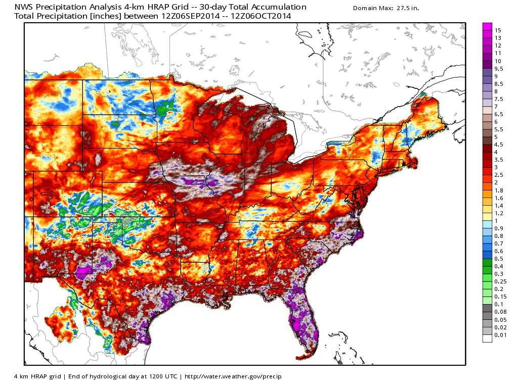
Despite the dry weather late September through October’s open, the past 30 days have featured beneficial to excessive Corn Belt rainfall…

nws_precip_east_30

Year-to-date has featured a wet eastern region.  Also note the dry pattern across the southwest (some places under 1″ YTD)!  Officially, we’re just slightly wetter than normal at IND, year-to-date (+0.53″).

nws_precip_conus2_270

Thinking longer term towards the darker, colder, and snowier months ahead… The JAMSTEC remains “bullish” on a regime plenty capable of delivering the cold and snowy “goods” for the region…  BTW- we usually post our annual winter outlook the first Friday of October.  Things have been very hectic as of late and we’re going to have to delay this release by a few weeks….

ssta.glob.DJF2015.1sep2014temp2.glob.DJF2015.1sep2014tprep.glob.DJF2015.1sep2014

Here We Go Again…

What a weather year this has been for central Indiana.  Snow and cold translated to wet and stormy as winter turned to spring.  Now as summer rumbles into the supposed “dog days” we’re really left with the exact opposite.  Our weather pattern will be dominated by a fast moving northwest flow over the upcoming (7) days and this spells an active and stormy open to the work week and next weekend, with an “island” of cool, pleasant weather thrown in the mix Wednesday through Friday.

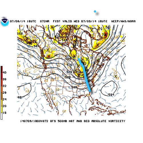
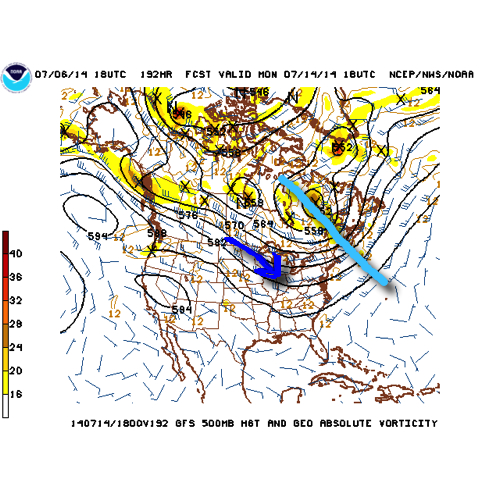
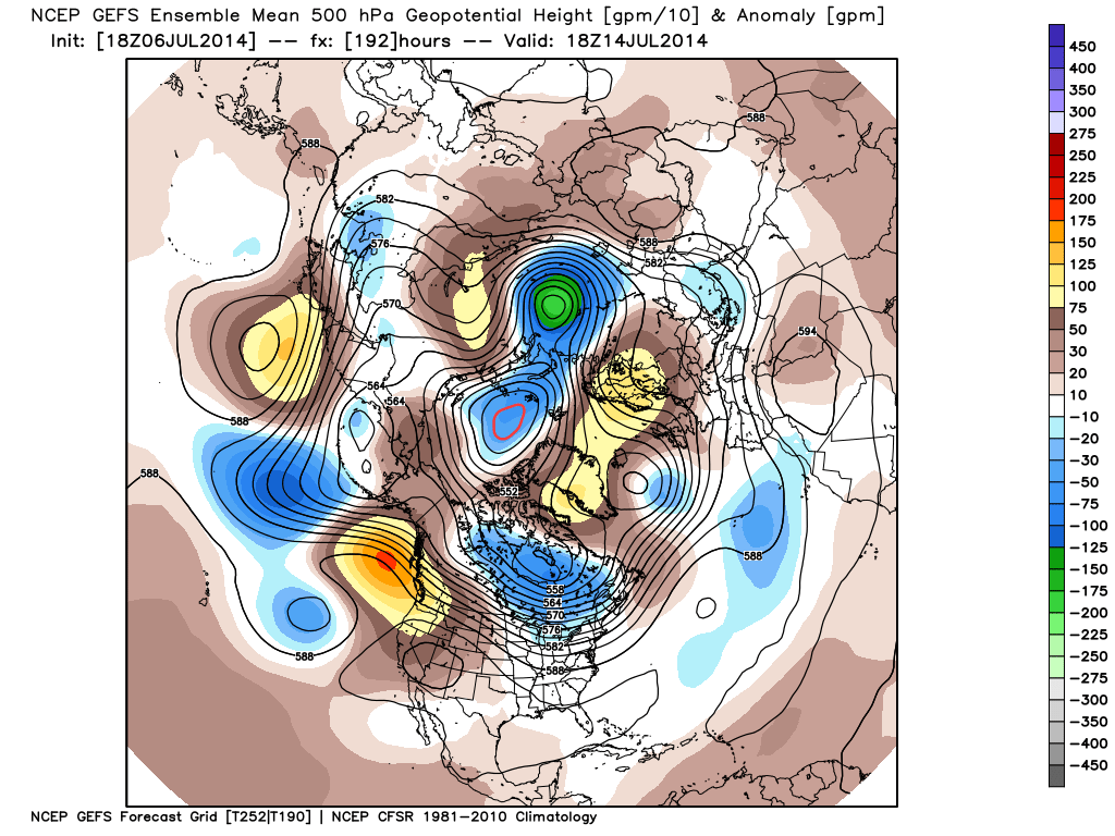
The GFS operational run shows that we’ll remain locked into the rather active northwest flow pattern through the upcoming week.  Note that while the trough axis moves east with time, the northwest flow remains intact.

1


2


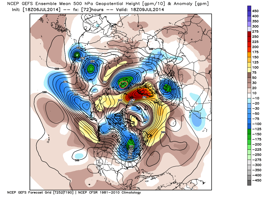
There’s excellent ensemble support from the GEFS and EC, as well.

a

b

The end result is a (7) day stretch that remains cooler than normal when all added up, highlighted by the cooler punch of air (worthy of open windows yet again) Wed-Fri.

4

This also remains quite the active pattern in regards to thunderstorm complexes and rounds of locally heavy rainfall.  We bracket late tonight into Monday morning and again Monday night into Tuesday, followed by next weekend for possible storm complexes that will make for a rather noisy time of things here.  As for the severe threat, we’ll have to keep a close eye on each complex.  It’s possible one or two of these could pose a damaging wind threat as they race southeast and that’s our biggest concern as of now.

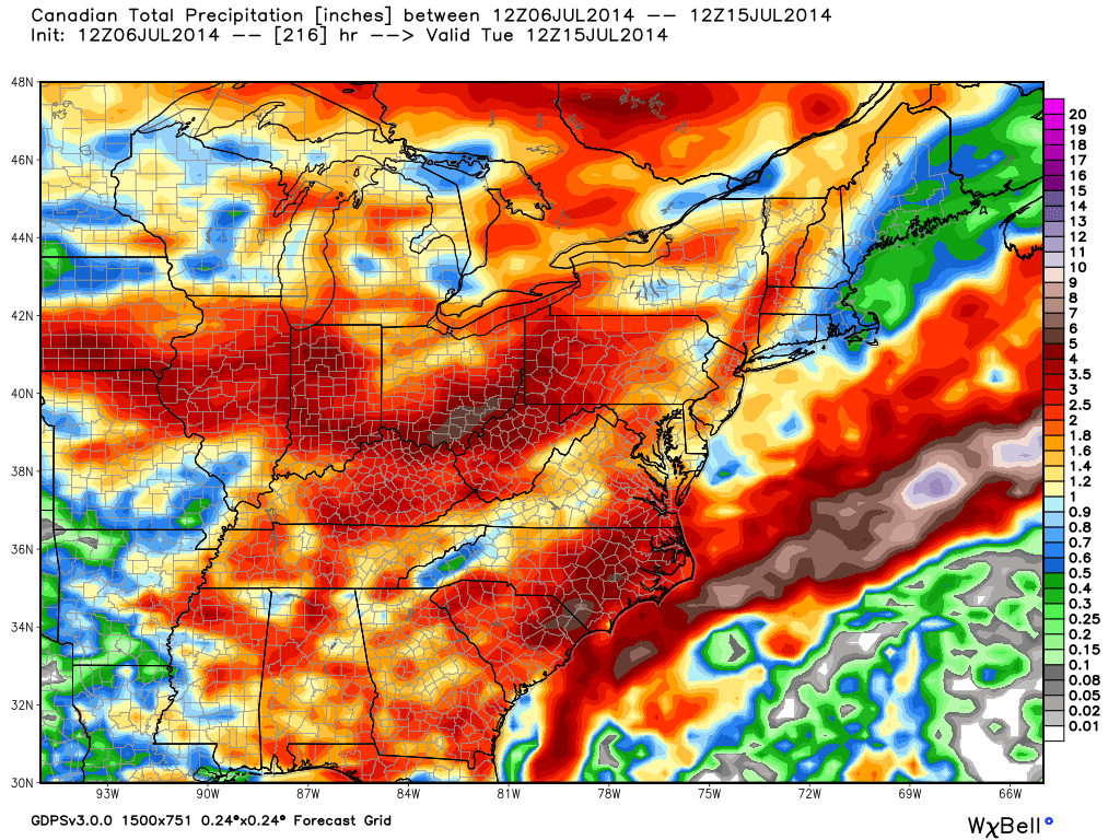
When you total it all up, the upcoming (7) day period, July 7th-14th, is likely to lead to more significant rainfall over the region.  The Canadian isn’t holding back, suggesting widespread 2-3″ totals.  That may be a bit “bullish,” but we’ll forecast 1.5″-2″ with ease during the upcoming week, including locally heavier totals.

5

Quick summary:

Monday through Tuesday will be highlighted by rainy and stormy periods before we introduce a much cooler and drier regime Wednesday through Friday.  Humidity builds over the upcoming weekend with additional rain and thunderstorm chances returning.

Lake-Driven APRIL Snow Showers…

Hard to believe we were in the 70s just passed the midnight hour Monday morning.  Feels like temperatures are now in the teens with snow showers and embedded heavier squalls across central Indiana- some of which have resulted in periodic slick travel conditions.

Note the lake Michigan connection to the snow “streamers” with that famous northwest to southeast orientation in this morning’s visible satellite image.

vis0

This morning’s radar shows the snow showers riding along I-65.

BlQk8_zCYAAGSs3

Highs today will struggle to reach 40 in many locations with wind chills in the teens and 20s.  A hard freeze is on tap tonight as all go into the middle to upper 20s.

Slow moderation will begin Wednesday…

Old Man Winter Isn’t Finished

Come this afternoon it’ll be tough to believe we were in the 70s over the weekend!  A cold front is moving through central Indiana this morning and resulting in showers.  Rain will continue in an off-and-on fashion today, becoming a bit more organized yet again later this afternoon and evening.  This will be in response to a wave of low pressure developing to our east, along the pressing strong cold front.

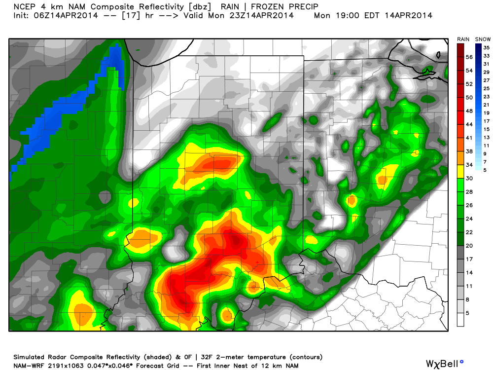
A look at the forecast simulated radar at 7pm this evening:

1

MUCH colder air will pour into the region today, complete with gusty northwest winds.  In fact, we’ll be in the 40s just after the lunchtime hour and the free-fall will continue.  30s arrive this evening and rain will begin to transition to wet snow.  Not all will see accumulation tonight, but a slushy accumulation of around half an inch will be possible where heavier snow persists.

A look at the forecast simulated radar towards 11pm-12am:

23

Temperatures will crash into the 20s by Tuesday morning.  I saw many folks at Lowes buying flowers yesterday…hopefully those folks aren’t planning on planting until later…

4

Tuesday will feature clearing skies, albeit unseasonably cold conditions.  We’ll remain in the 30s most of Tuesday, struggling to make it much above 40 by afternoon, along with a chilly northwest wind in place.  Lows Tuesday night/ Wednesday morning will drop into the lower to middle 20s.