Category: snow

Another Bout Of Rush Hour Wintry Mix; Longer Range Talk…

We think we’re dealing with another round of light freezing drizzle and a wintry mix for the Thursday morning commute.  Plan to allow extra travel time.

Forecast radar Thursday morning suggests freezing drizzle and a light wintry mix is in play across central Indiana.

Forecast radar Thursday morning suggests freezing drizzle and a light wintry mix is in play across central Indiana.

There’s some longer term data that’s in stark contrast from what a positive PNA should produce (yet alone a strong positive PNA).  Typical positive PNA pattern should promote an eastern trough and associated colder than normal pattern as drawn below:

PositivePNA

Needless to say, we disagree strongly with the NAEFS and GFS ensembles:

2014120312_054@007_E1_north@america_I_NAEFS@TEMPERATURE_anomaly@probability@combined@week2_186

Regardless, the future will tell!  

Permanent link to this article: https://indywx.com/another-bout-of-rush-hour-wintry-mix-longer-range-talk/

Hoping For Afternoon Sunshine; Tricky Thursday Morning…

Wed.

Thr.

Fri.

Sat.

Sun.

Mon.

Tue.

 Status-weather-snow-scattered-day-icon

 Status-weather-snow-scattered-icon

 Status-weather-showers-scattered-icon

 Status-weather-showers-day-icon

 Status-weather-clouds-icon

 Status-weather-showers-day-icon

 Status-weather-snow-scattered-day-icon

31/ 40

27/ 35

34/ 42

37/ 42

27/ 39

32/ 43

25/ 35 

Watch For Slick Spots This Morning…A light wintry mix of freezing drizzle, snow, and sleet fell across central Indiana during the overnight.  Most roads have been treated, but still leave extra time to reach your destination and travel safely.  We think we’ll get rid of the low clouds, fog, and pesky light wintry precipitation during the afternoon and introduce at least a look or two of sun into your forecast!  It’ll be a chilly day as highs struggle to reach 40.

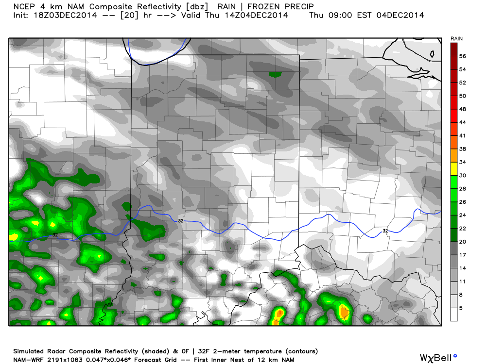
Tricky Thursday…Another fast moving disturbance will deliver light precipitation to central Indiana as early as Thursday morning.  With temperatures below freezing during the onset of precipitation, much of this may fall in the “frozen” or “freezing” form.  We’re concerned about light freezing rain and light sleet arriving during the morning commute Thursday and we’ll fine tune timing and precipitation type with tonight’s update.  Temperatures should slowly “warm” above freezing during the afternoon switching wintry precipitation over to just plain ole rain.  Stay tuned.

Wet Open To The Weekend…This morning’s model data is in much better agreement in regards to our wet weather maker slated for the opening to the weekend.  A slug of widespread moderate to heavy rain will push in here Friday and continue into early Saturday.  We think the back half of Saturday will feature drier air moving into the region which will set up a dry, but cold Sunday.

Cold Push Early Next Week…We’re siding with the colder solution early next week for now.  We forecast a cold front to blow through the area Monday afternoon with a quick shower possible (not a big deal).  Tuesday will feature colder northwest breezes and a scattered snow shower, or two.

Upcoming 7-Day Precipitation Forecast:

  • 7-Day Rainfall Forecast: 1.00″ – 1.50″
  • 7-Day Snowfall Forecast: Dusting to less than 1″

Permanent link to this article: https://indywx.com/hoping-for-afternoon-sunshine/

Tuesday Morning Wintry Mix….

Our high resolution models continue to be rather aggressive on the idea of a wintry mixture of snow, sleet, and freezing rain falling across central Indiana Tuesday morning. The HRRR…

You must be logged in to view this content. Click Here to become a member of IndyWX.com for full access.  Already a member of IndyWx.com All-Access?  Log-in here.

Permanent link to this article: https://indywx.com/tuesday-morning-wintry-mix/

Challenging Pattern…

Mon.

Tue.

Wed.

Thr.

Fri.

Sat.

Sun.

 Status-weather-snow-scattered-icon

 Status-weather-snow-scattered-day-icon

 Status-weather-clouds-icon

 Status-weather-snow-scattered-icon

 Status-weather-showers-scattered-icon

 Status-weather-showers-scattered-icon

 Status-weather-clouds-icon

29/ 35

26/ 37

32/ 43

27/ 35

33/ 47

37/ 47

33/ 44 

Wintry Mix For Some…Recall we mentioned last week that we’d have to keep close tabs on the week 1 (this week) situation as the pattern looked to present challenges (cold highs to the north and an active storm track south).  That’s certainly the case as today is a perfect example of model data struggling on the northern extent of the precipitation and the associated combination with colder air moving south.  This morning we’ve had reports of sleet in the Avon and Fortville communities.

We’ll forecast cloudy skies today with best chances of light wintry mix impacting the I-70 corridor and points south.  Another little “ripple” of energy will move along the frontal boundary south of the region and provide the chance of a wintry mix this afternoon into tonight.

Tuesday and Wednesday will turn quieter after the chance of morning flurries Tuesday morning.

Late Week System…We’ll keep close eyes on another storm system Thursday.  Once again, the fine line between liquid, freezing, and frozen precipitation forms will lie across our immediate region.  For now we’ll simply forecast a wintry mix of snow, sleet, and rain Thursday afternoon switching over to a cold rain Friday.  Stay tuned.  And deviation south or north will have an impact on precipitation type.

Half And Half…The opening to the new weekend looks to be a wet one as an active storm track continues.  We’ll then introduce drier air Sunday.

Upcoming 7-Day Precipitation Forecast:

  • 7-Day Rainfall Forecast: 0.50″ – 0.75″
  • 7-Day Snowfall Forecast: Dusting 

Permanent link to this article: https://indywx.com/challenging-pattern/

Catching Up And Looking Ahead…

From the IndyWx.com family to yours, we wish you a very happy Thanksgiving! Thank you for taking the time to read our content daily and for all of your support…

You must be logged in to view this content. Click Here to become a member of IndyWX.com for full access.  Already a member of IndyWx.com All-Access?  Log-in here.

Permanent link to this article: https://indywx.com/catching-up-and-looking-ahead/