Hang In There You Lovers Of Winter…

As I sit here in the good ole weather office, snow is falling and the Christmas lights are shining at the McMillan household.  Just doesn’t get any better!  Unfortunately, for winter lovers out there, the overall weather pattern over the upcoming couple weeks won’t offer up much in the way of wintry precipitation, as strong ridging results in a rather prolonged period of uneventful and mild weather across these parts (at least compared to normals).
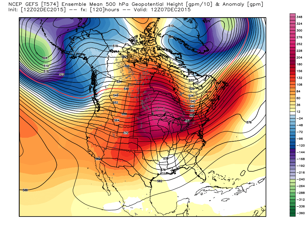
The GFS ensembles show ridging expanding over our region this weekend into early next week. Source: Weatherbell.com

That said, there are indications that our weather pattern may be changing enough to at least put us on the playing field for wintry potential as we rumble into the back half of the month, including the all-important Christmas period.

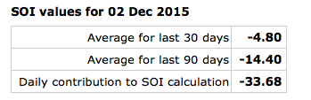
The SOI continues to tank and while the impacts (storminess) of a tanking SOI are delayed, we’re in the time frame now where this may result in busy times, or an active storm track, come mid and late December.
Screen Shot 2015-12-02 at 6.28.52 PMRight on schedule, we see the GFS ensembles going towards a much different look around mid month.  Note the heights (ridging) pulling further and further north while the southern stream energizes.  This is likely a byproduct of that tanking SOI that we see now.
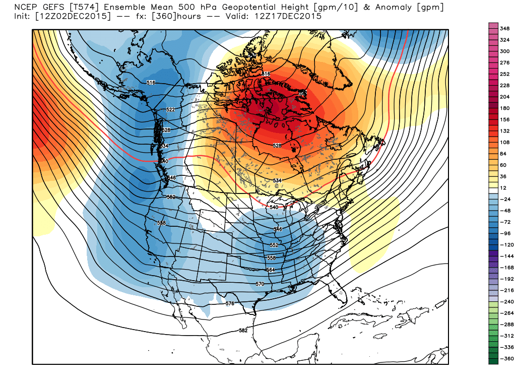
GFS ensembles. It's a "night and day" difference out at mid month. Source: Weatherbell.com
GFS ensembles. It’s a “night and day” difference out at mid month. Source: Weatherbell.com

We also note the AO, or Arctic Oscillation, trending more in a negative to neutral direction.  While still not significantly negative, this is an improvement from a winter lover’s perspective from the positive values we’ve seen of late.
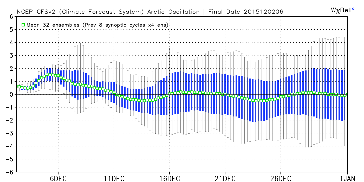
AOWe’re only two days into meteorological winter and still feel very confident about our winter outlook, focusing on the back half of winter for the worst conditions, relative to averages.  That said, even though the first couple of weeks of December, as a whole, may not be as cold or snowy as you’d like, it doesn’t mean we can’t reverse things enough to put us in a position to make for more “interesting” times around these parts leading up to Christmas….

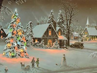
Could this be the scene this Christmas across central IN?  Much more later!Christmas
Sunshine Returns (Finally); Wednesday Snow Showers…

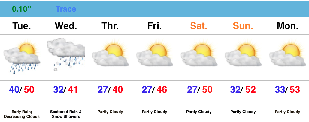
Screen Shot 2015-12-01 at 7.09.18 AMHighlights:

  • Sunshine returns
  • Rain and snow showers Wednesday
  • Extended period of dry weather coming with a moderating trend

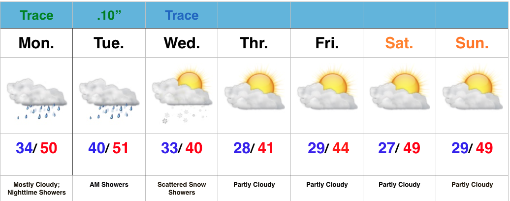
Showers raced through central IN during the overnight, but those are now long gone and clouds are beginning to decrease from west to east across the state.  All-in-all, a very nice Tuesday, and first day of December, is on the way!

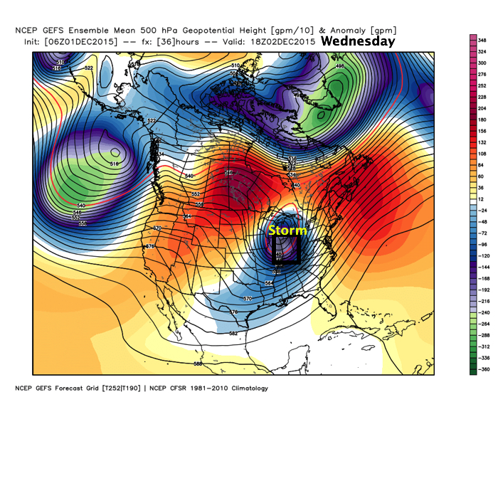
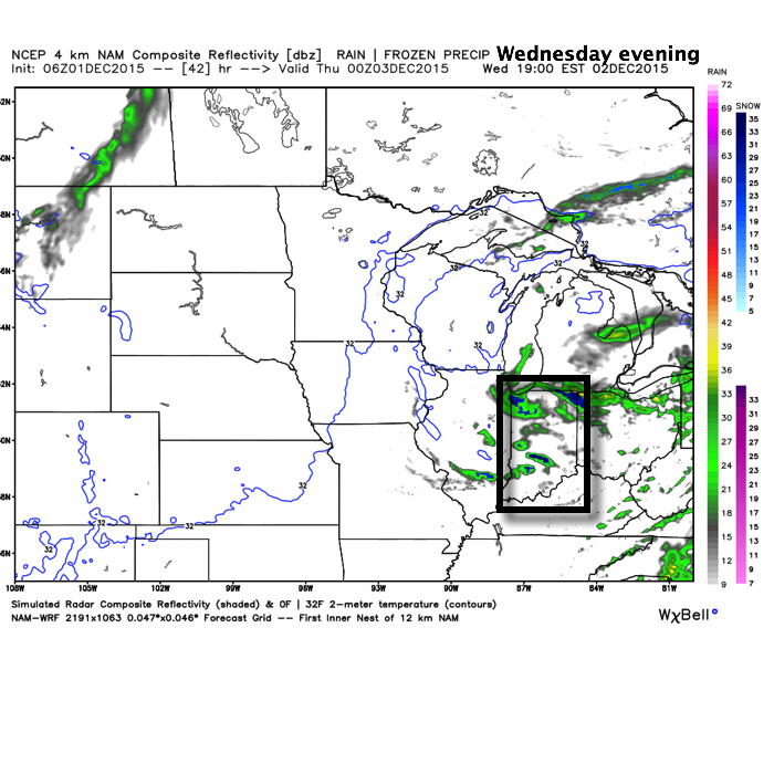
Enjoy it, as Wednesday’s weather will be much more like you’d expect around this time of the year.  Clouds will increase late tonight and give way to mixed rain and snow showers, particularly Wednesday afternoon and evening.  This is in association with the area of low pressure, currently impacting MN with snow, that will slowly move east into the Great Lakes.

Wednesday

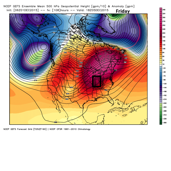
WedEveningOur cold and wintry “set back” will be short-lived as we get into an extended stretch of dry and milder weather heading into the weekend.  The culprit?  An expanding ridge across the northern tier.

FridayThis ridge looks to remain in control of our weather through early to middle next week before our next storm system may impact the region.

Considerable Cloudiness Remain; Mid Week Snow Flakes…

Screen Shot 2015-11-30 at 7.27.36 AMHighlights:

  • Showers/ drizzle return tonight
  • Scattered snow showers Wednesday
  • Dry and mild to close the week

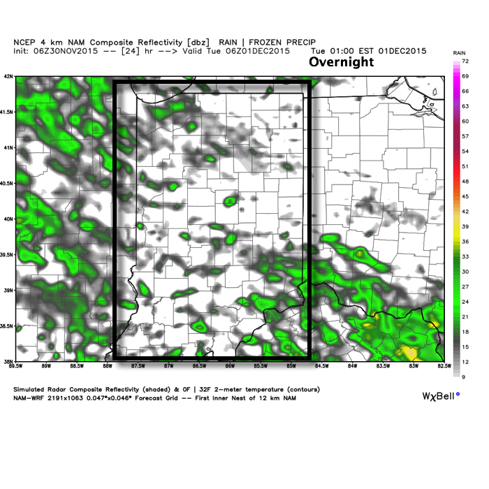
We’re getting the work week kicked off with weather conditions that have been common over the Thanksgiving weekend- cloudy and cold.  Moisture will return slowly this evening and overnight with showers and drizzle moving back in.  We’re not looking at significant rains by any stretch of the imagination, but this is what the radar could look like during the overnight, courtesy of Weatherbell.com.

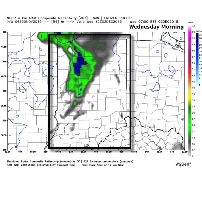
OvernightShowers will exit Tuesday morning and most of the day will be rain-free.  Colder air will slowly move back into the state Wednesday morning and as wrap-around moisture pivots through central and northern IN Wednesday scattered snow showers will result.  We’re not looking at any accumulations, but it’ll be nice to see a little of the white stuff falling.

WednesdayMorningOnce our Wednesday snow showers exit we’ll get back to dry skies and mild temperatures to wrap up the work week and head into the weekend.

Frigid Start; Looking Ahead To Thanksgiving…

Screen Shot 2015-11-22 at 9.27.08 AMHighlights:

  • Arctic air begins to moderate
  • Next storm system arrives late Thanksgiving
  • Another punch of cold air next weekend

Before we discuss what lies ahead, let’s look back at yesterday’s snow event that “overachieved” for many.  Particularly just northwest of the city where 2″-4″ fell.  Snowfall rates were heavy enough to overcome the initially warm surface temperatures, and it was very impressive to see the way the snow accumulated considering this was a November event that took place from late morning into the early afternoon (when the sun angle does the majority of it’s work).  This was an impressive first snow of the season and this morning’s snowpack is widespread throughout the Mid West.

nsm_depth_2015112205_MidwestThe visible satellite this morning shows the snow cover across the central and northern portions of the state, where single digits and teens were common.

SnowpackThe next few days will feature dry and cold conditions.  While we’ll remain below average, temperatures will slowly begin to moderate from the arctic intrusion of today.

We’ll get into a SW (milder air flow) regime for a brief period of time Thanksgiving Day out ahead of our next storm system that will move in Thanksgiving Night and Black Friday.  Clouds will increase and moisture will spread into the region during the aforementioned time period.  Most of the rain will fall Friday, so plan on taking the rain gear with you as you venture out to begin that Christmas shopping.

Thanksgiving

BlackFridayMuch colder air will pour into the region Thanksgiving weekend and we’ll have to maintain a close eye on the evolution of things late next weekend into early December.  Models will continue to waiver on specific solutions over the next few days, but there will be an attempt of a southern stream storm system coming out and “attacking” the cold air in place…

Rain Changes To Snow Today; Busy Pattern Into Early December…

Screen Shot 2015-11-21 at 7.47.29 AMHighlights:

  • Rain changes to snow
  • Early season arctic air settles in
  • Next storm arrives for Thanksgiving
  • Eyeing a cold open to December

Our storm system is arriving on schedule this morning as rain is overspreading central IN.  Just north of the city, snow flurries are falling as we type this (Boone County).  Further north it’s mainly a snow event.  Elsewhere, rain will continue to overspread the region before transitioning to snow from late morning into the early afternoon from northwest to southeast.

Here’s what the radar may look like as we progress from morning into the afternoon

8aSat
Forecast radar 8a, courtesy of Weatherbell.com
10a forecast radar, courtesy of Weatherbell.com
Forecast radar at 1p, courtesy of Weatherbell.com


Forecast radar 2p, courtesy of Weatherbell.com

We think rain will transition to snow for Indianapolis, itself, just after lunch and may come down heavily for a time from early afternoon into the mid afternoon hours before tapering off as evening arrives.  While it may be falling “fast and furious” for a time, warm surface temperatures will limit accumulations from what they would be otherwise.  Here’s our updated snowfall map.

112115SnowMap3The big concern this evening will be flash freezing as a gusty NW flows travels over a fresh snowpack just to our north and helps temperatures plummet into the teens tonight.  Wind chills in the single digits can be expected followed by highs tomorrow only in the 20s.

Moderation will occur as we move through Thanksgiving week before our next storm system arrives late Thanksgiving Day.  Rain and breezy conditions will move in late Thursday into Friday before a much colder air mass oozes into the state late in the period.  This may set the stage for a rather “interesting” open for December as a storm system tries to “attack” the cold…