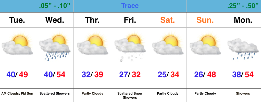
We’re rumbling closer to Christmas with each and every passing day. Thankfully, for the most part this week, weather will be nice for shoppers and early travelers. Two systems of note are slated to impact the area this week- a band of scattered showers will move through here with a frontal boundary Wednesday. Secondly, upper level energy will team up with a shot of arctic air to provide a flurry/ snow shower opportunity Friday.
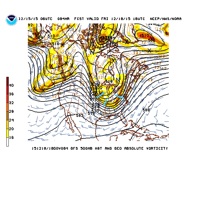
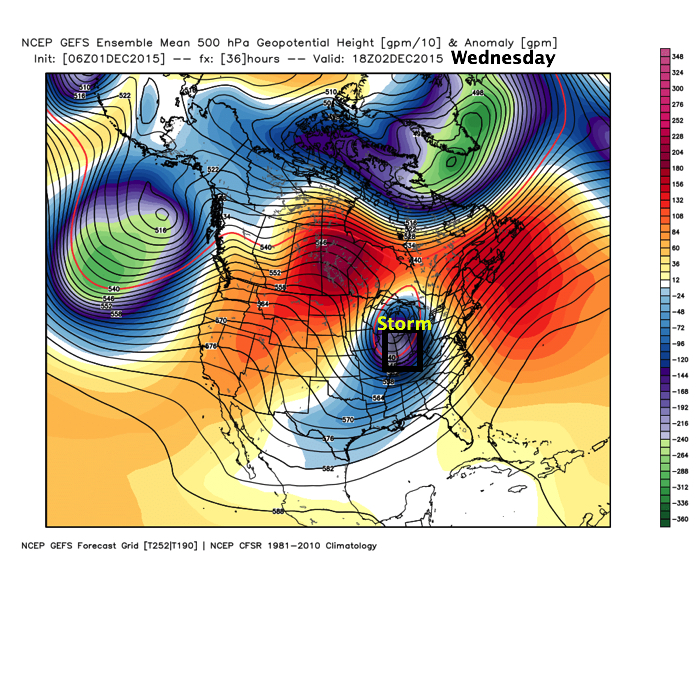
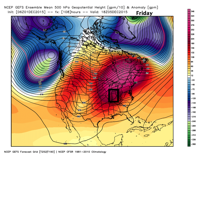
The 500mb chart Friday shows upper level energy capable of producing flurries/ scattered snow showers. Source: NCEP
Unfortunately for you winter lovers out there, the cold coming will leave about as quickly as it arrives. We’re back to a warm and moist SW flow early next week that will lead to more unseasonably warm temperatures Christmas week (new possible records may be set), along with showers returning to our forecast as early as Monday.
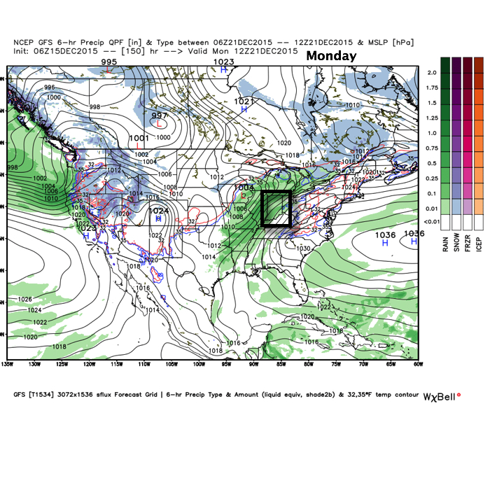
Warm and wet weather returns early next week. Source: Weatherbell.com
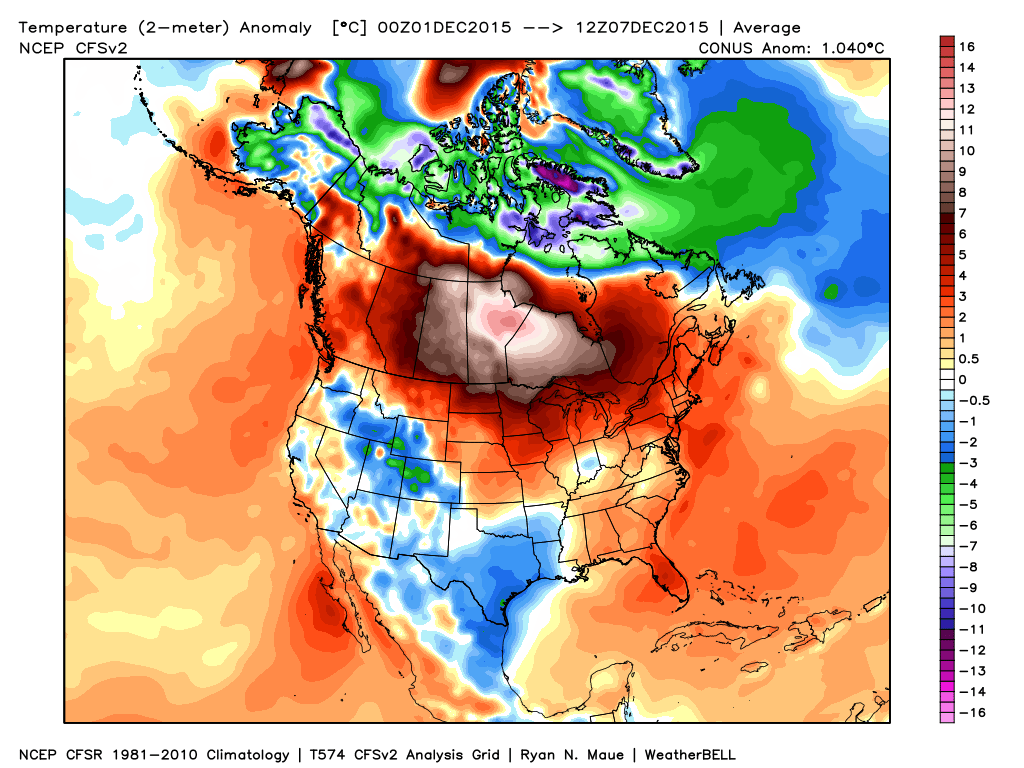
Ironically, the only area of normal to below normal air (with the exception of the Rockies and southern Plains) is located over our region, month-to-date.
From a winter lover’s perspective, this December has been one to forget this far, and it’ll only grow more frustrating in the days ahead (we still forecast mid to upper 60s over the weekend).
The basic drivers of our pattern remain generally unchanged from ideas in October when we posted our Winter Outlook. Our complete Winter Outlook can be found here. We feel the need to remind some that we thought we would get off to warmer than normal and relatively quiet start:
“We feel this model best represents the likely milder than average start to winter before colder conditions mid and late winter.”
“We think the winter opens warmer than normal and relatively dry before shifting towards a colder than average pattern for mid and late winter.”
“The word “volatile” comes to mind at times.”
In short, there’s nothing out there that would suggest any reasons we should deviate from our current winter outlook that’s out there. Despite the warm start, we still feel the winter, when all totaled up, will end up slightly colder than normal. Additionally, though still falling short of normal snowfall, we also feel there will be plenty of winter weather potential come mid and late winter.
That leads us to the shorter term and what happens after the near record warmth of the upcoming weekend.
To sum it up:
A very active pattern develops this weekend with storms to track every 3-4 days.
Despite a storm or two that may have a favorable storm track for winter potential, it’s important to note sufficient cold air is tough to come by in the more immediate term.
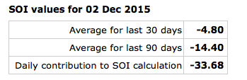
Last week’s crashing SOI (Southern Oscillation Index) will lead to poor run-to-run consistency.
We do see a way the pattern could get cold enough for more interesting times the closer we get to Christmas. Does this mean we’re guaranteeing a snow storm? No, but, as mentioned this morning, the teleconnections will at least make an attempt to transition closer towards a state that could offer up wintry mischief at some point during the last (10) days of the month.
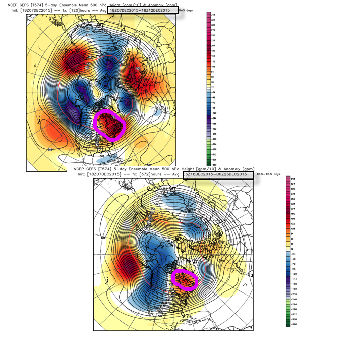
Bottom line is that the overall pattern is one that favors more in the way of warmer than average conditions through the next couple weeks before we begin transitioning towards more sustained wintry conditions mid and late winter. The idea here is that with each successive storm that comes through, it’ll cut into the mean ridge position and the heights will continue to lift further and further north with time over the upcoming 10-14 days. The GFS ensembles show this.
Is it an ideal set up for “lock and load” winter? Not at all. Is it an improvement that can at least offer up a couple attempts of wintry potential around Christmas? Yes.
As stated above, in the longer term, based off current data and seasonal modeling, there’s no reason to walk away from the idea the slow start to winter continues for the duration. Patience friends. 🙂
The near term period is about as quiet as you’ll get it this time of year so that gives us an opportunity to search for the next “trouble maker.” Out…
You must be logged in to view this content. Click Here to become a member of IndyWX.com for full access. Already a member of IndyWx.com All-Access? Log-in here.
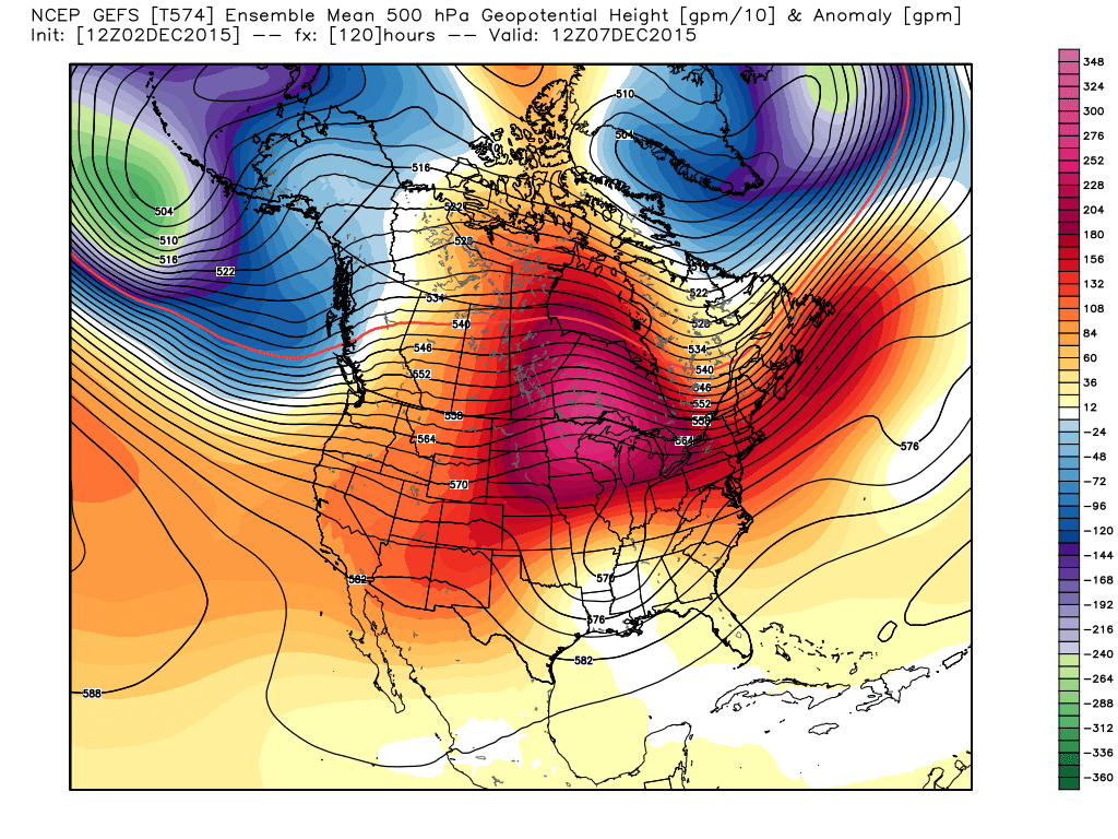
As I sit here in the good ole weather office, snow is falling and the Christmas lights are shining at the McMillan household. Just doesn’t get any better! Unfortunately, for winter lovers out there, the overall weather pattern over the upcoming couple weeks won’t offer up much in the way of wintry precipitation, as strong ridging results in a rather prolonged period of uneventful and mild weather across these parts (at least compared to normals).
The GFS ensembles show ridging expanding over our region this weekend into early next week. Source: Weatherbell.com
That said, there are indications that our weather pattern may be changing enough to at least put us on the playing field for wintry potential as we rumble into the back half of the month, including the all-important Christmas period.
The SOI continues to tank and while the impacts (storminess) of a tanking SOI are delayed, we’re in the time frame now where this may result in busy times, or an active storm track, come mid and late December.
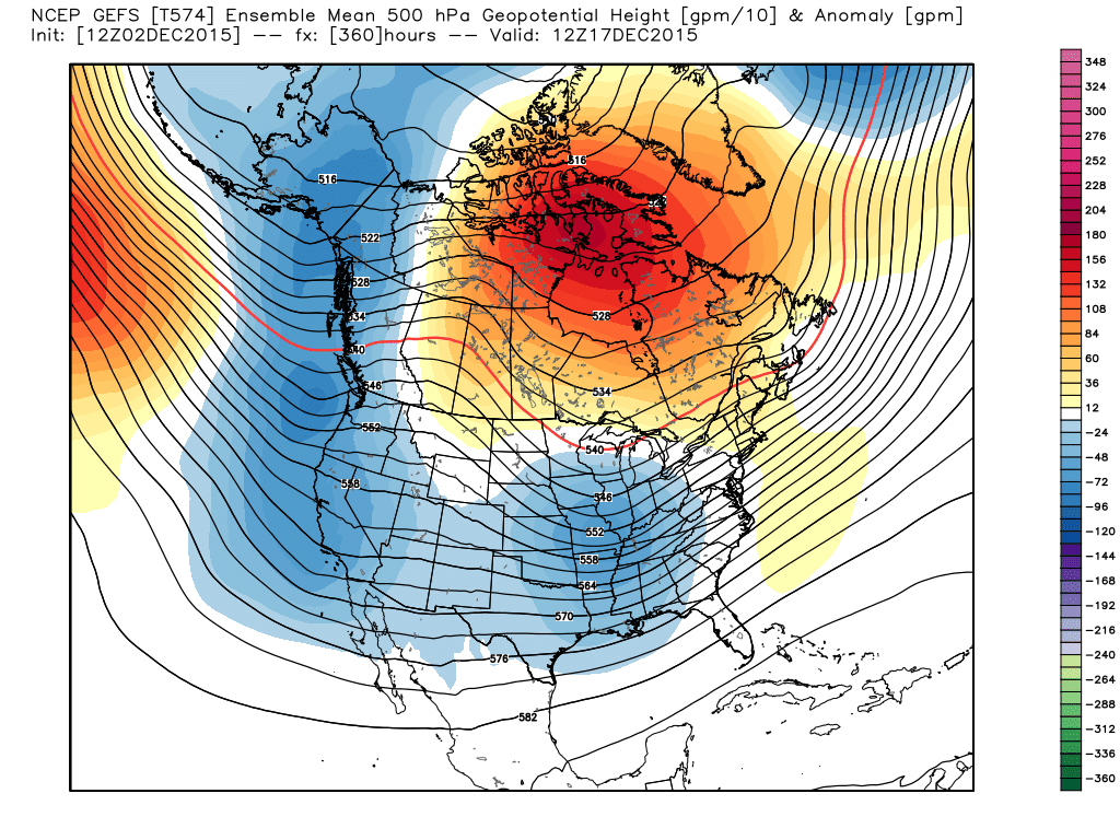
Right on schedule, we see the GFS ensembles going towards a much different look around mid month. Note the heights (ridging) pulling further and further north while the southern stream energizes. This is likely a byproduct of that tanking SOI that we see now.
GFS ensembles. It’s a “night and day” difference out at mid month. Source: Weatherbell.com
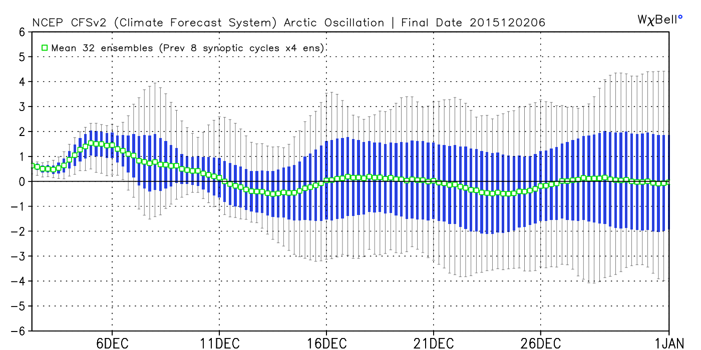
We also note the AO, or Arctic Oscillation, trending more in a negative to neutral direction. While still not significantly negative, this is an improvement from a winter lover’s perspective from the positive values we’ve seen of late.
We’re only two days into meteorological winter and still feel very confident about our winter outlook, focusing on the back half of winter for the worst conditions, relative to averages. That said, even though the first couple of weeks of December, as a whole, may not be as cold or snowy as you’d like, it doesn’t mean we can’t reverse things enough to put us in a position to make for more “interesting” times around these parts leading up to Christmas….
Could this be the scene this Christmas across central IN? Much more later!
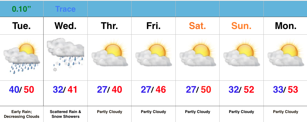
Extended period of dry weather coming with a moderating trend
Showers raced through central IN during the overnight, but those are now long gone and clouds are beginning to decrease from west to east across the state. All-in-all, a very nice Tuesday, and first day of December, is on the way!
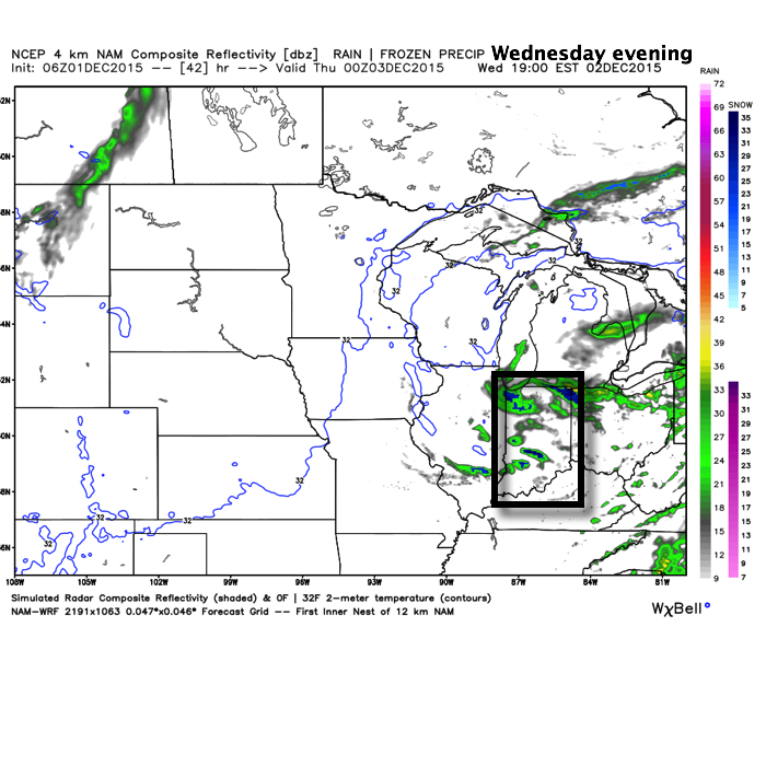
Enjoy it, as Wednesday’s weather will be much more like you’d expect around this time of the year. Clouds will increase late tonight and give way to mixed rain and snow showers, particularly Wednesday afternoon and evening. This is in association with the area of low pressure, currently impacting MN with snow, that will slowly move east into the Great Lakes.
Our cold and wintry “set back” will be short-lived as we get into an extended stretch of dry and milder weather heading into the weekend. The culprit? An expanding ridge across the northern tier.
This ridge looks to remain in control of our weather through early to middle next week before our next storm system may impact the region.
 Highlights: