
You must be logged in to view this content. Click Here to become a member of IndyWX.com for full access. Already a member of IndyWx.com All-Access? Log-in here.
Category: Severe Weather
Permanent link to this article: https://indywx.com/2016/07/17/sunday-video-update-storms-heat/
Jul 08
Friday Morning Rambles…
1.) We’ve got another warm, humid day dialed up and as a cold front moves in this afternoon, scattered strong to severe storms are possible. We think east-central Indiana stands the greatest threat at experiencing a severe storm later this evening.
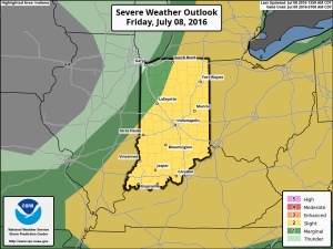
 2.) The aforementioned cold front will sweep through the state tonight and allow a much drier and cooler air mass to push in for the weekend. We’ll enjoy a downright pleasant feel this weekend, including lots of sunshine. Enjoy!
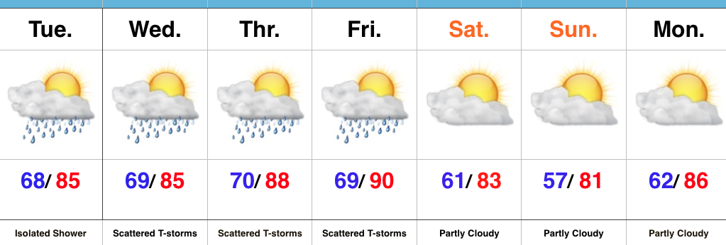
 3.) Dry weather should continue into early next week, but wet and stormy weather will return as early as Tuesday, continuing into the latter portions of the week.
 This is the start of what should be a rather wet period for mid and late month.
 4.) This is also a continued “transient” pattern through the end of the month, meaning we really don’t see any sort of sustained dry, hot weather in the foreseeable future…
Permanent link to this article: https://indywx.com/2016/07/08/friday-morning-rambles-3/
Jul 07
Thursday Morning Video Update…
Severe potential is there tonight, but how does convection to our west during the day impact the situation downstream (locally) for tonight? We’re monitoring closely, but for the purpose of…
You must be logged in to view this content. Click Here to become a member of IndyWX.com for full access. Already a member of IndyWx.com All-Access? Log-in here.
Permanent link to this article: https://indywx.com/2016/07/07/thursday-morning-video-update-3/
Jul 05
Entering A Stormy Period…
We’re enjoying quiet times across Indiana this evening, but times are quickly changing to put us into a stormy position between Wednesday morning and wrapping up the work week.
While the overall pattern is an easy one to label from a broad scale perspective as “stormy,” the precise details are incredibly difficult to pin point much more than 12-24 hours in advance. With that said, most of the state is very much in fair game for periods of storms (generally tracking in a NW to SE fashion) between now and the end of the work week. Eventually, drier air will set us up for a very pleasant weekend, including lots of sunshine and cooler temperatures. In fact, latest data still suggests we can expect to wake up to the 50s Sunday and/ or Monday morning(s).
Before we enjoy the pleasant weekend weather, the first of a series of storm complexes will approach Wednesday morning. Mesoscale Convective Complexes (MCCs) can be a true pain for short-term modeling to handle, but the overall idea this evening is for the first of (2) complexes to impact parts of the region Wednesday morning.
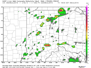
This is an idea what the radar may look like around 9a. This would be the same complex that will deal quite the blow to portions of the eastern Plains and upper Mid West tonight (localized damaging straight line winds will be an issue to our NW). Thankfully, we expect weakening of this complex as it dives off to the SE, in our general direction.
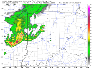 We’ll go through a quiet period during the afternoon hours before a second surge of storms takes aim on the region tomorrow night into Thursday morning (again, understanding we’ll have to “sure up” timing as we go).
 Additional storm complexes will follow Thursday into Friday before that drier air gets here. Some of these could be strong to severe.
While rainfall amounts won’t be uniform, there’s the potential for some neighborhoods to get 2″-3″ of rain between now and week’s end (where storms train).
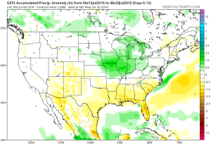
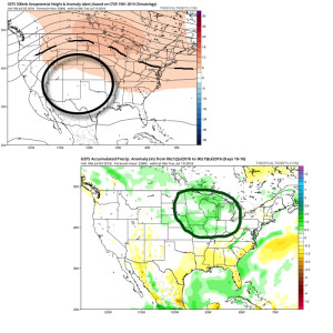
 Looking ahead, after a dry weekend and open to next week, indications point towards a return of wet and active times as we approach Day 10. Long range ensemble data backs up the wet, stormy look nicely, and there’s really no end in sight…
Permanent link to this article: https://indywx.com/2016/07/05/entering-a-stormy-period/
Jul 05
Periods Of Storms Before A Pleasant Weekend…
 Highlights:
- Muggy times return
- Multiple storm chances mid/ late week
- Strong-severe storm potential
- Drier weekend
Air You Can Wear…A quick step out of the door this morning will quickly remind you that we’re in the heart of summer. A tropical feel will remain through the middle and latter portions of the work week. While an isolated shower is possible this afternoon, we should remain mostly dry across the state.
Better chances of showers and thunderstorms will return Wednesday, and we target the chances of two round of storms- morning and night. Some of these storms could be strong to severe, including damaging straight line winds. Don’t be surprised if updated Storm Prediction Center outlooks place a Slight Risk into portions of the state Wednesday.
Additional storm chances will be present Thursday and Friday before a drier air mass arrives in time for the weekend. With the drier air will also come cooler nights- lower 60s Saturday morning and upper 50s Sunday morning. After the warm, humid time of things the next few days, the drier air mass will feel quite refreshing.
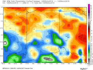
Upcoming 7-Day Precipitation Forecast:
- Snowfall: 0.00″
- Rainfall: 1″ – 2″
Permanent link to this article: https://indywx.com/2016/07/05/periods-of-storms-before-a-pleasant-weekend/
Jul 03
Unseasonably Cool; Heavy Rains…
 Highlights:
- Heavy rain
- Unseasonably cool
- Turning warmer
- Active, stormy time later in the week
Jacket And Rain Gear Needed…The first of two rounds of widespread, soaking rains is pushing across central IN this morning. Periods of moderate to heavy rains will develop later tonight as round two arrives on the scene. Localized flooding is likely tonight and Monday morning. The overall set-up is one that features a stationary front draped across the region with ripples of energy (low pressure) moving along the boundary. In addition to the wet weather, this will also set up quite the temperature gradient across the state today. Here across central IN, jackets will be needed all day with highs struggling to climb much out of the middle 60s. Downstate, temperatures will zoom into the 80s with a severe component added into the mix tonight for southern IN (with the focus primarily being straight line winds).
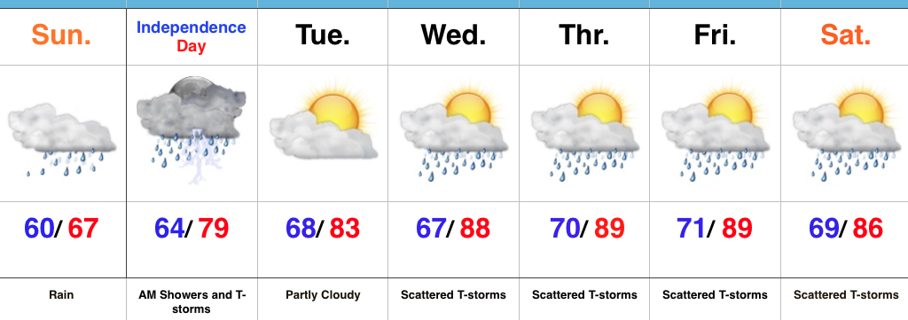
Showers and thunderstorms will continue Independence Day, but we’re still hopeful in thinking we begin to dry things out for the afternoon and evening. That’s great news for the fireworks and festivities planned tomorrow evening.
We begin to heat things back up and add storms into the mix for mid and late week as the region gets into an active NW flow regime. The potential is there for a couple of rather noisy storm complexes later this week. We’ll keep a close eye on things.
Upcoming 7-Day Precipitation Forecast:
- Snowfall: 0.00″
- Rainfall: 3.5″-4.5″ (locally heavier amounts)
Permanent link to this article: https://indywx.com/2016/07/03/unseasonably-cool-heavy-rains/
Jun 26
PM Strong Storms…
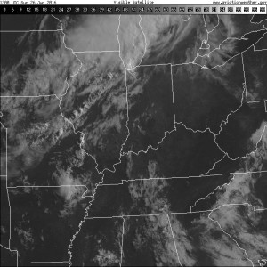
The morning is off to a sunny, muggy, and warm start. Temperatures will rise into the lower 90s this afternoon, but when we look at heat indices, it’ll feel like around 100 degrees across many central IN neighborhoods.
The visible satellite shows the sunny skies in place right now, but we note the cloud deck off to the northwest. That’s in association with a frontal boundary that will press through our region tonight.
 A line of thunderstorms will develop later this afternoon and a few of these could be strong to severe as they push to the south. Large hail and damaging straight line winds are of greatest concern. We think best chances of thunderstorms across central IN will come during the mid to late afternoon hours into the early evening.
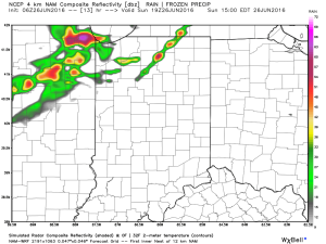
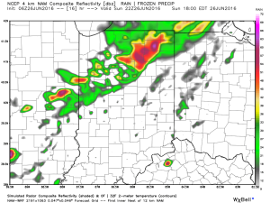
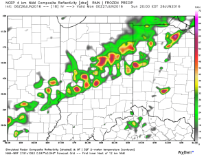
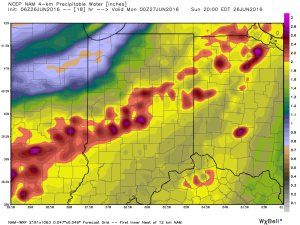
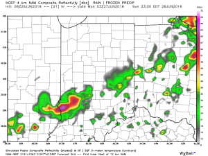 The air mass is loaded with moisture today. In fact, precipitable water values will zoom to 2″+ this afternoon and suggest the threat of torrential rainfall with any storm that develops.
 Once to Tuesday, a MUCH cooler, drier air mass will arrive on the scene and help set up an unseasonably cool close to the month.
Permanent link to this article: https://indywx.com/2016/06/26/pm-strong-storms/
Jun 22
Video Update On Tonight’s Severe Weather Event…
You must be logged in to view this content. Click Here to become a member of IndyWX.com for full access. Already a member of IndyWx.com All-Access? Log-in here.
Permanent link to this article: https://indywx.com/2016/06/22/video-update-on-tonights-severe-weather-event/
Jun 22
Wednesday Morning Update…
The first of two waves of showers and thunderstorms is moving through the region this morning. It’s the second wave of storms this evening/ tonight that has most of our attention.
The Storm Prediction Center has included more of central IN in a Moderate Risk of severe weather with the morning update.
 All modes of severe weather are possible this evening and tonight, including tornadoes, hail, and damaging straight line winds. Localized flash flooding is also possible where storms train.
Specific timing remains in question and we’re still not confident in the way short-term model data is handling the situation. Fine tuning will be required as we move into the afternoon hours.
Once we rid the morning storms, clearing should develop for the afternoon and help boost temperatures into the middle 80s. Sunshine is a bad thing this afternoon. It won’t take much to destabilize things and ignite the second round of storms to our northwest this evening (southern WI/ northern IL). That second round of storms is the one expected to pack a punch for some as they race southeast.
Have a means to get the latest weather information later today and ensure your family’s severe weather plan is in place.
Much more later this afternoon!
Permanent link to this article: https://indywx.com/2016/06/22/wednesday-morning-update-2/
Jun 21
Latest Thinking On What Will Be A Busy Wednesday…
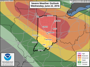
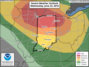
The SPC (Storm Prediction Center) maintains a significant severe weather risk across Indiana Wednesday. A Slight risk encompasses the southern portions of the state, while an Enhanced risk takes up residence across central Indiana. Finally, a Moderate risk is located across the northern third of the state. Given the latest data, we wouldn’t be surprised if a portion of the Enhanced/ Moderate risk areas are upgraded to a rare High risk during the early Wednesday morning SPC update. Regardless, we want to be very clear that Wednesday is a potentially dangerous weather day across Indiana.
 We won’t bore you with the meteorological ingredients/ lingo that are coming together to lead to an active Wednesday with this post, but please know that nearly all severe weather parameters point to the threat, and even likelihood, of an active day.
That said, there are unknowns. How does morning convection impact our ability to heat/ destabilize things during the afternoon? Are models underestimating the cold pool that will likely develop with the storms during the afternoon/ evening? If so, a further southeast track and more robust situation could unfold (when compared to what forecast radar products suggest as of this post Tuesday evening).
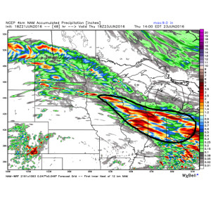
While all modes of severe weather are certainly possible, for our immediate region, we’re particularly concerned for the threat of widespread damaging winds and flash flooding. It wouldn’t surprise us if localized 3″+ amounts fall across portions of central and northern IN Wednesday. Precipitable water values (PWATs) surging to 2″+ give increased confidence on localized flash flooding, especially considering the recent wet times.
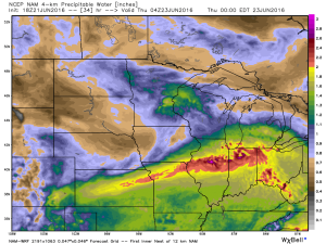
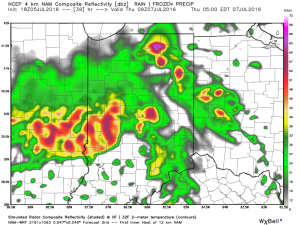
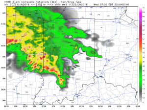
 The first of multiple storm clusters will likely be moving into central IN Wednesday morning. Here’s an idea of what the radar may look like around 7a.
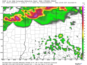
 We think we undergo a “lull” in the action Wednesday afternoon before a potentially more serious complex of storms blows into town during the evening hours. We caution that we’re not as confident on specific timing with the evening round of storms.
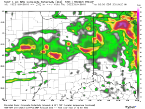 Current data would imply a tornado threat for areas from northern IL into northwestern IN with the afternoon/ evening convection before “morphing” into a more widespread damaging wind threat as the line propels southeast into the nighttime hours. Timing will have to be fine tuned as Wednesday morning arrives.
To close, if you take anything from this post, please understand the importance of knowing your family’s severe weather safety plan. Have a means of getting the latest watch and warning information from the National Weather Service and take any and all bulletins seriously.
Much more later!
Permanent link to this article: https://indywx.com/2016/06/21/latest-thinking-on-what-will-be-a-busy-wednesday/