
You must be logged in to view this content. Click Here to become a member of IndyWX.com for full access. Already a member of IndyWx.com All-Access? Log-in here.
Category: Severe Weather
Permanent link to this article: https://indywx.com/2019/02/06/wednesday-morning-video-update-heavy-rain-severe-threat-give-way-to-much-colder-air-and-a-potential-late-weekend-winter-event/
Feb 05
Whole Lot Of Weather Going On…
There’s sure no shortage of active weather, and unfortunately (or fortunately- depending on your perspective), there’s no letup in sight. As we look ahead, we see a fascinating battle of heavyweights set to duke it out for control of our mid and late February pattern. Before we get into some of the longer range model updates, let’s focus on the short and medium term challenges.
Heavy Rain
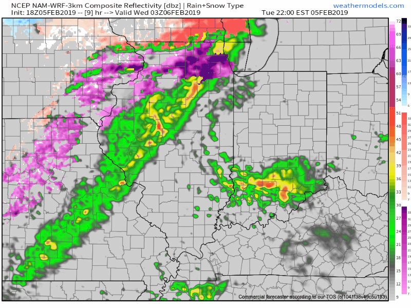
We continue to target (3) distinct windows where rainfall will be heaviest:
I. Late tonight-Wednesday morning
II. Wednesday night-Thursday morning
III. Thursday evening
In general, widespread 2″ to 2.5″ totals are expected in area rain gauges with heavier amounts across south-central Indiana (where flood risks are highest).
The other item to note? The potential of strong and gusty thunderstorms Thursday afternoon into the early evening. These would be located directly ahead of the cold front. While we’re not anticipating a widespread major event, temperatures and dew points will approach 60 deg. and the atmosphere will be favorable to support a few strong gusts that may mix down to the surface.

Sharply Colder
The cold front that will deliver the heavy rainfall for our midweek will sweep through central Indiana around 4p-5p. Behind the boundary, sharply colder air will blow in on strong and gusty northwest winds Thursday night. Daytime highs (actual highs will occur at midnight Friday) will only top out in the lower 20s with wind chill values in the 0s most of the day.

Winter Threat Late Weekend-Early Next Week?
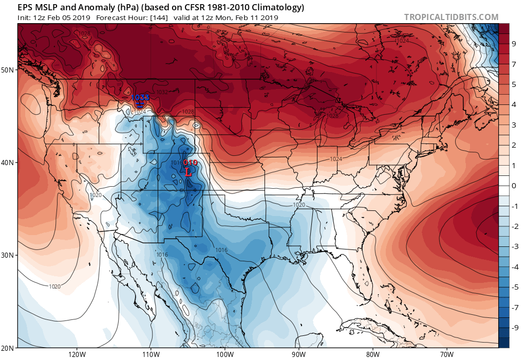


The fresh batch of cold air in here to wrap up the work week will lay the ground work for potential wintry mischief late weekend into early next week. While the cold still isn’t set to truly establish itself (still think we’re a week-10 days away from that), just enough cold may be around to present the opportunity for an accumulating central and northern Ohio Valley winter threat in the Sunday-Tuesday period. Stay tuned as we fine tune things.
The hesitation that we still have from beginning to “ring the bells” a little louder in the aforementioned period is the position of the high in front of the storm and forecast strongly positive AO. Both of these argue against the idea of this being a widespread wintry event for the southern, and potentially as far north as central Ohio Valley. The early idea here as of now is that we’ll be looking at a wintry mix event to rain for central and southern areas with more of an opportunity for substantial snow across the northern portions of the Ohio Valley. Again, stay tuned as we continue to fine tune things.
Longer term, today’s MJO update continues to take things into Phase 8 and you don’t need us to cover the end result again (think cold) at this point. Should we get the other teleconnections to line-up (AO, PNA, NAO) then a 2-3 week period of significant winter weather would ensue during the 2/20-3/10 timeframe…
Permanent link to this article: https://indywx.com/2019/02/05/whole-lot-of-weather-going-on/
Jan 29
Dangerous Cold Now; Accumulating Snow By Thursday Evening…
You must be logged in to view this content. Click Here to become a member of IndyWX.com for full access. Already a member of IndyWx.com All-Access? Log-in here.
Permanent link to this article: https://indywx.com/2019/01/29/dangerous-cold-now-accumulating-snow-by-thursday-evening/
Jan 28
Severe Arctic Blast; Looking Ahead…
The first of two cold fronts is sweeping through the state this evening. Temperatures are turning cold enough to combine with leftover moisture and light snow showers to result in…
You must be logged in to view this content. Click Here to become a member of IndyWX.com for full access. Already a member of IndyWx.com All-Access? Log-in here.
Permanent link to this article: https://indywx.com/2019/01/28/severe-arctic-blast-looking-ahead/
Jan 28
Tracking Two Cold Fronts; Dangerous Cold Arrives Tuesday Evening…
We’re tracking two cold fronts as we open the new work week. The first will pass without a whole lot of fanfare this evening. However, the second boundary (the true arctic front) means business Tuesday afternoon/ evening.
We notice a band of mixed precipitation moving into central IN before sunrise. This will swing through the state, changing to rain as it does so, through the morning and into the early afternoon. The reason? Just enough mild air working in on southwesterly breezes ahead of the frontal boundary.
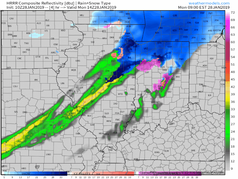
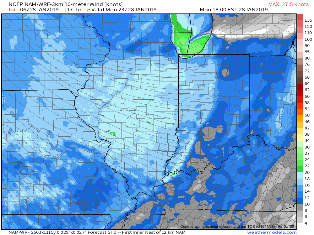
The front will pass through the city around or just after rush hour. Gusty winds and falling temperatures are ahead this evening.
By morning, most of central Indiana will awake to temperatures in the single digits.
The second front (true arctic boundary) will be barreling towards the state at this time and will pass Tuesday evening. It’ll hit like a “wall” with gusty winds, brief, but intense snow squalls, and plummeting temperatures.
Central Indiana will be greeted with temperatures nearing 10° below zero and wind chill values of 30° to 40° below zero Wednesday morning.

Please take this cold seriously and complete preparations today. Thankfully, milder times are ahead as we head into the weekend…
Permanent link to this article: https://indywx.com/2019/01/28/tracking-two-cold-fronts-dangerous-cold-arrives-tuesday-evening/
Jan 27
Period Of Severe Cold Arrives Early-Mid Week…
[
You must be logged in to view this content. Click Here to become a member of IndyWX.com for full access. Already a member of IndyWx.com All-Access? Log-in here.
Permanent link to this article: https://indywx.com/2019/01/27/period-of-severe-cold-arrives-early-mid-week/
Jan 24
Active Pattern; Severe Cold Looms Next Week…
You must be logged in to view this content. Click Here to become a member of IndyWX.com for full access. Already a member of IndyWx.com All-Access? Log-in here.
Permanent link to this article: https://indywx.com/2019/01/24/active-pattern-severe-cold-looms-next-week/
Jan 23
Multiple Snow Makers; Pattern Threatens Severe Cold Next Week…
You must be logged in to view this content. Click Here to become a member of IndyWX.com for full access. Already a member of IndyWx.com All-Access? Log-in here.
Permanent link to this article: https://indywx.com/2019/01/23/multiple-snow-makers-pattern-threatens-severe-cold-next-week/
Jan 23
6-10 Day Outlook: Significant Winter Event Looms…
The 6-10 day period will likely be dominated by an air mass of arctic origin, and the potential is present for the period to begin with a rather significant winter event. Models have occasionally “teased” the idea of dropping the PV (Polar Vortex) over the Great Lakes during this period, and that’s not something that’s off the table given the pattern here. Suffice it to say, we expect this period to run much colder than average.
While there will be some specifics we’ll have to sort through as time gets closer, this is remarkable model agreement when looking at the GFS and European ensemble sets in the medium term.
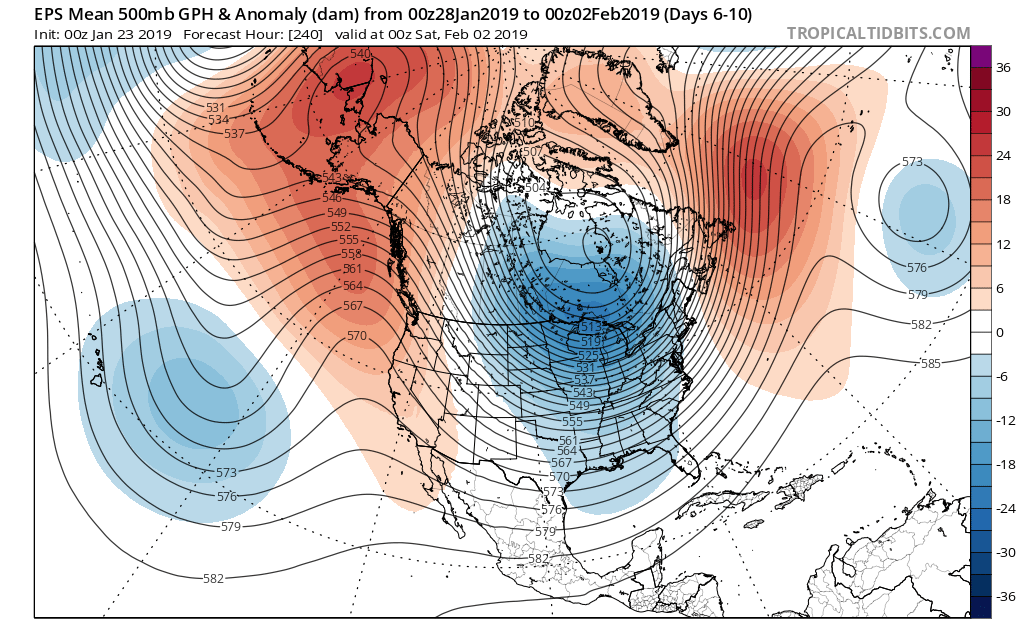
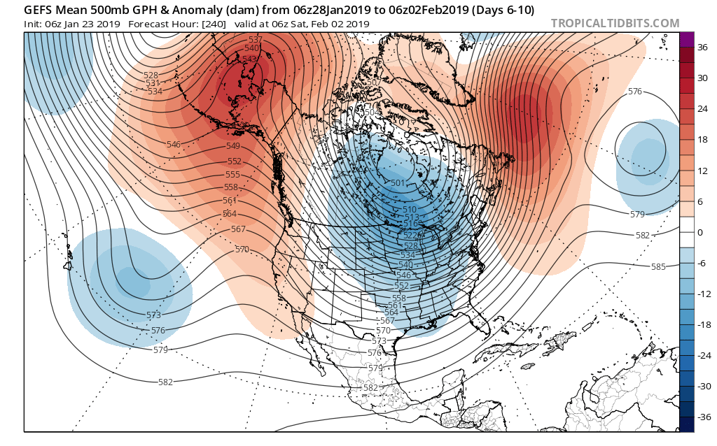 We’ve been discussing the opportunity where we see the flow slow enough to allow one or two of these clipper systems in the medium to longer range to deepen into a stronger storm system. That may be the case late weekend into early parts of next week and it’s something we’re keeping a close eye on. In addition to measurable snow, the potential is on the table for notable cold in the 6-10 day period, including multiple days below zero. In the extreme, this is the type pattern that could lead to double digit below zero cold across central Indiana- not including the wind chill.
Stay tuned.
Permanent link to this article: https://indywx.com/2019/01/23/6-10-day-outlook-significant-winter-event-looms/
Jan 19
Blizzard-Like Conditions Develop This Afternoon Into Tonight…
While warm air advection (WAA) created an added challenge this morning (freezing rain north of the city, itself, and rain south of I-70), colder air is working south late this morning and will result in a changeover from freezing rain/ rain to snow over the next couple hours from north to south.
We expect the transition to snow to take place in and around Indianapolis between 1p and 2p.
 As upper level energy tracks northeast this evening, strong frontogenesis will help a “deformation band” expand in coverage and intensify across the state. This will lead to elevated snowfall intensity as the afternoon gives way to evening. In fact, snowfall rates will likely approach 1″/ hour across central and eastern portions of the state at times during the mid-to-late afternoon and into the evening hours.
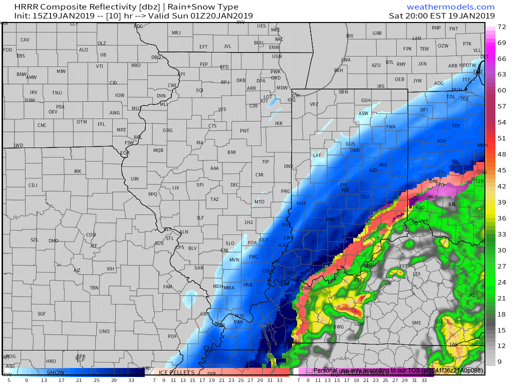
8p forecast radar.
As this is taking shape, winds will also begin to crank this afternoon and evening. Gusts in excess of 50 MPH are expected across central and eastern regions- including Indianapolis.
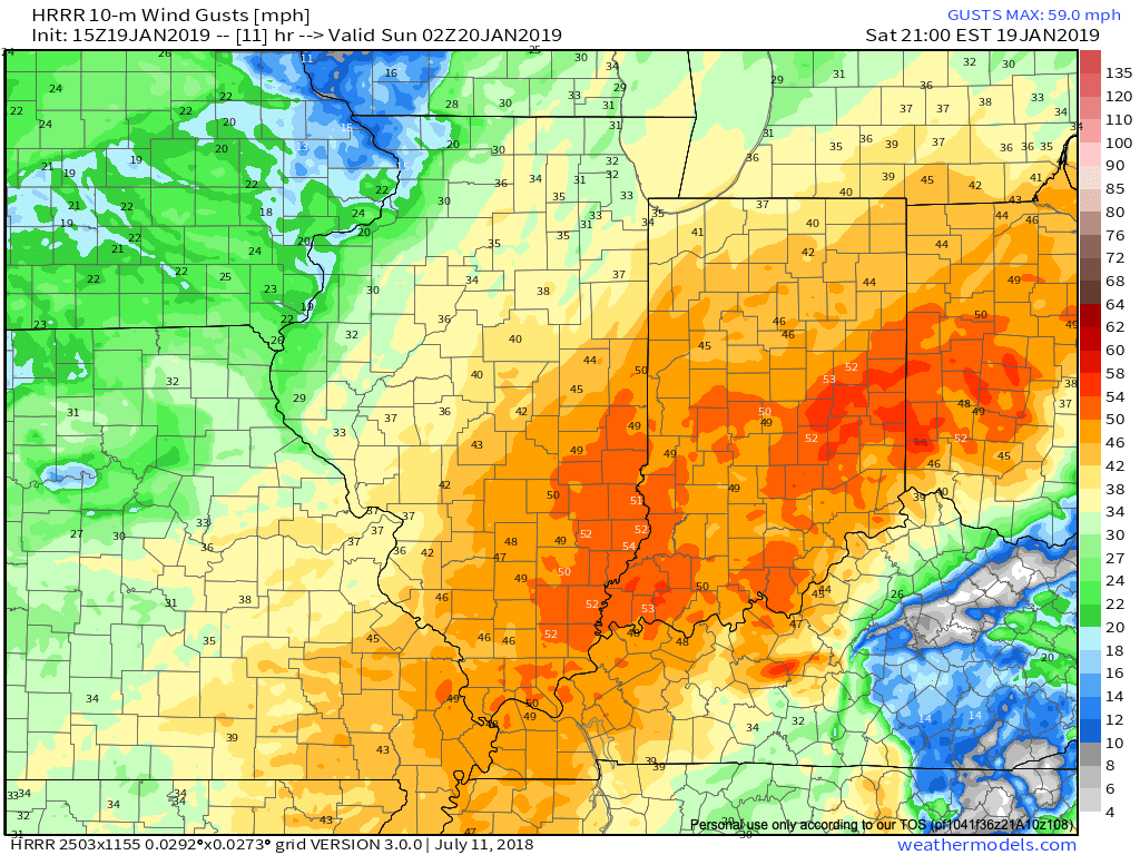 Obviously this will create concerns for power outages, but the other major worry is for developing blizzard-like conditions and whiteouts through the late afternoon into tonight.
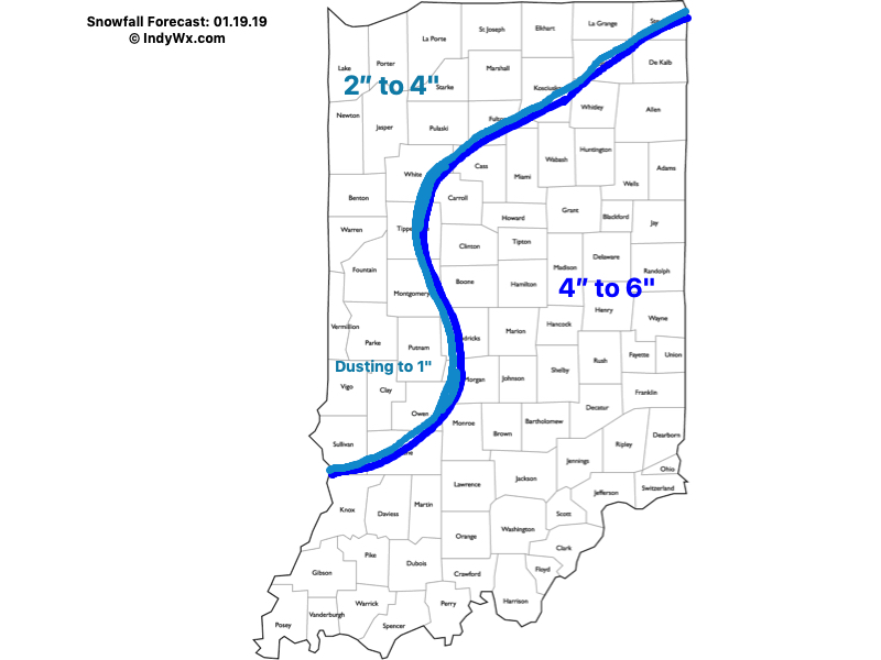
As for snowfall totals, the consensus of latest 12z data continues to support our updated snowfall forecast from this morning.
 We’ll have additional updates later this afternoon here on IndyWx.com and on our social media accounts.
To close, we highly encourage not traveling this afternoon. Conditions are expected to rapidly deteriorate as we move through the next several hours. For many across central and east-central Indiana, roads will likely become impassable by evening with the combination of severe wind gusts and increasing snowfall rates. Major problems from blowing and drifting snow are expected.
More here in a bit! Stay safe!
Permanent link to this article: https://indywx.com/2019/01/19/blizzard-like-conditions-develop-this-afternoon-into-tonight/