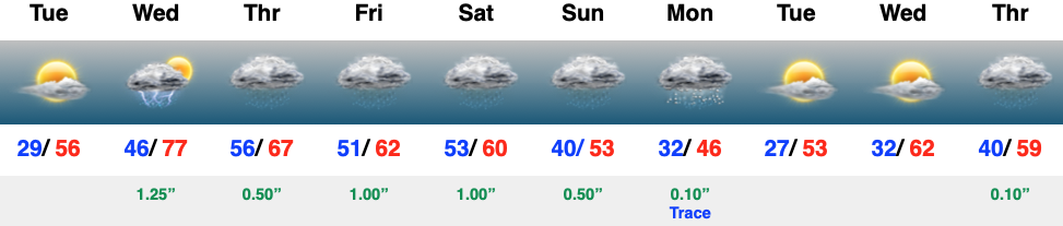
Category: Severe Weather

Weekly #AGwx and #Severe Outlook…

Weekly Highlights:

I. Strong Easter storm system leads to a widespread severe weather outbreak across the southern Plains (today), Deep South (Sunday), and into the central/ southern Ohio Valley (Sunday night).

II. An anomalous trough carves itself out over the eastern half of the country leading to well below average temperatures in the week ahead.

The Deep South into the Carolinas and Mid Atlantic will be in the cross hairs of well above average rainfall this week.
Most of the country will experience well below average temperatures in the week ahead.
Most of immediate central Indiana should pick up close to 1″ of rain during the upcoming 7-day period. Heavier amounts will likely fall across southern Indiana south into the TN Valley.
A major severe weather outbreak is expected from the southern Plains into the Deep South over the next 24-48 hours.

Forecast Period: 04.11.20 through 04.18.20

More specific to central Indiana, today will feature mostly cloudy, but mostly dry conditions. As a warm front lifts north across the state tonight, chances of showers will be on the increase. Easter will feature a deepening low pressure system racing northeast from the Ark-la-tex region across the central Ohio Valley and into the Great Lakes by Monday morning. Most of Easter Sunday will also feature precipitation-free hours, but showers and thunderstorms will be on the increase tomorrow evening into the nighttime. (If you have family and friends across the Deep South, please reach out and ensure they are aware of the developing situation and corresponding strong risk of significant severe weather Easter Sunday). While the threat of severe weather isn’t as great up this way, we’re closely monitoring the potential of a squall line impacting areas into southeastern Indiana late Sunday night into the overnight Monday- continuing into central portions of the Ohio. An associated damaging wind threat would ensue with this line of storms. Finally, as the cold front sweeps through the region Monday morning, rain should come to an end around or just before daybreak, but much cooler and very windy conditions will develop. Monday should feature northwest gusts of 40 to 50 MPH.

The remainder of the forecast period will be dominated by unseasonably chilly conditions and a couple of weaker, fast-moving, disturbances. With the cold air in place, mixed rain and snow showers are possible midweek with a disturbance.

Tuesday through Thursday mornings feature the best chance of temperatures falling to or below the freezing mark. Frost isn’t anticipated outside of this time frame due to clouds and/ or wind.

Permanent link to this article: https://indywx.com/2020/04/11/weekly-agwx-and-severe-outlook-2/

Details On Our Easter Storm; Fresh Long Range Thoughts…

You must be logged in to view this content. Click Here to become a member of IndyWX.com for full access.  Already a member of IndyWx.com All-Access?  Log-in here.

Permanent link to this article: https://indywx.com/2020/04/10/details-on-our-easter-storm-fresh-long-range-thoughts/

VIDEO: Chilly Pattern Settles In; Easter Storm, And Looking Ahead To Potential Wet End To April…

You must be logged in to view this content. Click Here to become a member of IndyWX.com for full access.  Already a member of IndyWx.com All-Access?  Log-in here.

Permanent link to this article: https://indywx.com/2020/04/09/video-chilly-pattern-settles-in-easter-storm-and-looking-ahead-to-potential-wet-end-to-april/

VIDEO: Timing Out Tonight’s Storms As Transition To Much Colder Air Takes Place…

You must be logged in to view this content. Click Here to become a member of IndyWX.com for full access.  Already a member of IndyWx.com All-Access?  Log-in here.

Permanent link to this article: https://indywx.com/2020/04/08/video-timing-out-tonights-storms-as-transition-to-much-colder-air-takes-place/

VIDEO: Strong-Severe Storms Possible Overnight; Sustained Chill Mid-Late April…

You must be logged in to view this content. Click Here to become a member of IndyWX.com for full access.  Already a member of IndyWx.com All-Access?  Log-in here.

Permanent link to this article: https://indywx.com/2020/04/07/video-strong-severe-storms-possible-overnight-sustained-chill-mid-late-april/

Dinnertime Rambles: A Lot Going On In The Weather Department The Next Few Weeks…

This is a “locked and loaded” weather pattern that will require a great deal of attention over the next 2-3 weeks. We’ll have to take things one at a time, but the combination of strong storms to start, much colder air on the horizon, and the potential of wintry “fun and games” in the 6-10 day period is enough to hopefully distract you from the day-to-day news, and provide a little extra entertainment during these unprecedented times.

First things first and that’s the short-term storm situation:

All is quiet this evening, but a warm front currently draped from central IA, IL, and into southern IN will begin lifting north during the overnight. As this takes place, thunderstorms will erupt across northern Indiana late evening into the overnight hours before riding southeast into northern and central Ohio. A few stronger cells are possible, but most of these should remain below severe levels. Most of central Indiana should miss out on this activity.

With the warm front placed well north of the area tomorrow, the warmest temperatures of the spring thus far are expected. Additionally, that associated southwesterly flow will aid in moisture transport north through the day. Stepping outside tomorrow, you’ll certainly feel the difference with the increased warmth and humidity. Highs should top out in the middle 70s for most of central Indiana with dew points (shown below) climbing into the middle 60s.

The bulk of our Tuesday should be rain and storm free, but that will begin to change late tomorrow night as a new round of storms begins to organize. While high resolution guidance continues to struggle with the exact placement of this new round of storms, we’d encourage those across all of central and southern parts of the state to remain weather-aware tomorrow night and set those weather radio alerts to “on.” The primary concern of strong to severe storms that may develop late tomorrow night (mostly after 10p) includes large hail and the potential of damaging straight line wind. The Storm Prediction Center (SPC) maintains a good chunk of the immediate region in a Slight Risk tomorrow night into the predawn hours Wednesday.

Finally, one last round of showers and thunderstorms will accompany a strong cold front late Wednesday night into early Thursday morning (most of these should remain below severe levels).

Thursday will feature much cooler and blustery conditions as that northwest flow develops.

Thankfully, high pressure will briefly gain control of our area as we close the work week and head into the first half of Easter weekend. This will allow calmer weather conditions to return, but “brief” is the key word.

By Easter, itself, a new system will deliver rain before potentially ending as wet snow late Sunday night.

Even colder air will follow early next week, and we’re not done where that came from. There are indications on this evening’s computer models that the upper air pattern may come together to allow for a rather significant “phased” storm system in the longer range. It’s certainly far too early to speculate on that, but whether there’s a strong storm or not, the combination of a developing negative EPO and MJO with eyes set to rumble through Phases 1,2, and 3 lead us to believe this isn’t just some fleeting chilly pattern. Instead, this is liable to take up residence for the better part of the upcoming 2-3 week period. Big storm or not in the Week 2 time frame, it’s a safe bet those along and north of the Ohio River or into the high ground of the east TN/ western NC mountains haven’t seen the last of the snow for the season.

Remember, we’re only the messenger…

Permanent link to this article: https://indywx.com/2020/04/06/dinnertime-rambles-a-lot-going-on-in-the-weather-department-the-next-few-weeks/

VIDEO: Timing Out Potential Strong Storms; Prolonged Chilly Pattern On The Horizon…

You must be logged in to view this content. Click Here to become a member of IndyWX.com for full access.  Already a member of IndyWx.com All-Access?  Log-in here.

Permanent link to this article: https://indywx.com/2020/04/06/video-timing-out-potential-strong-storms-prolonged-chilly-pattern-on-the-horizon/

VIDEO: Briefly Warmer And Unsettled; Reasons Behind The Significant Pattern Change Ahead…

You must be logged in to view this content. Click Here to become a member of IndyWX.com for full access.  Already a member of IndyWx.com All-Access?  Log-in here.

Permanent link to this article: https://indywx.com/2020/04/05/video-briefly-warmer-and-unsettled-reasons-behind-the-significant-pattern-change-ahead/

Weekly #AGwx And #Severe Outlook…

The first Saturday in April can only mean one thing and that’s the return of our weekly #AGwx and Severe Weather Outlook. Similar to last year, this will be posted each Saturday morning through the month of September.

Weekly Highlights:

I. A strong area of low pressure will move in off the Pacific and provide heavy rain across CA, including intense mountain snow Sunday through Wednesday.

II. A strong cold front will move through the Midwest and Ohio Valley Wednesday into Thursday. This will result in a drastic change from late spring like temperatures to more winter-like by late next week.

Below normal precipitation is expected over the next week across a good chunk of the country.
Ahead of a strong late week cold front, temperatures will pop to well above average levels through the 1st half of next week. 

7-day rainfall amounts should average right around 0.50″ for our immediate area.
Organized, widespread severe weather isn’t expected across the country over the upcoming 7-days.

More specific to central Indiana, we’ll have 3 weather makers to track over the upcoming week:

This afternoon- A cold front will pass through the state without much fanfare. A few showers are possible here and there, but some won’t see a drop of rain and those that do can expect only light amounts.

Tuesday through Thursday- Scattered showers and thunderstorms will impact the area during this time frame as a couple of fast moving disturbances track across the Ohio Valley. A strong cold front will cross the region Thursday with a band of rain followed by windy and much colder air to close the week and head into next weekend.

Week 2 (April 11th-18th) trends are for much colder air along with the prospects of light mixed rain/ snow showers at times. There’s the threat of a stronger system late in the Week 2 time frame that we’ll continue to monitor.

Permanent link to this article: https://indywx.com/2020/04/04/weekly-agwx-and-severe-outlook/

VIDEO: Short-Term Update On Tonight’s Severe Weather/ Flooding…

You must be logged in to view this content. Click Here to become a member of IndyWX.com for full access.  Already a member of IndyWx.com All-Access?  Log-in here.

Permanent link to this article: https://indywx.com/2020/03/28/video-short-term-update-on-tonights-severe-weather-flooding/

IndyWx.com