You must be logged in to view this content. Click Here to become a member of IndyWX.com for full access. Already a member of IndyWx.com All-Access? Log-in here.
Category: Record Weather
Permanent link to this article: https://indywx.com/video-heavy-rain-moves-in/
Feb 19
Near Record Warmth & More Heavy Rain…
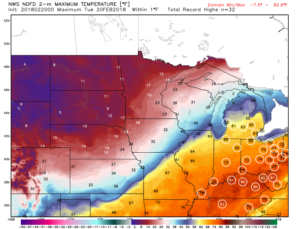
The big weather story Tuesday across central Indiana will be the near-record warmth. Typically it’s not until mid-May that average high temperatures climb into the lower to middle 70s, but we’re going to get an early taste of May tomorrow afternoon. Several records are in jeopardy of falling across the Ohio Valley Tuesday.
 Steadiest rains will fall across the northern third of the state Tuesday with scattered downpours through the morning and afternoon hours across central Indiana.

Forecast radar 12p Tuesday.
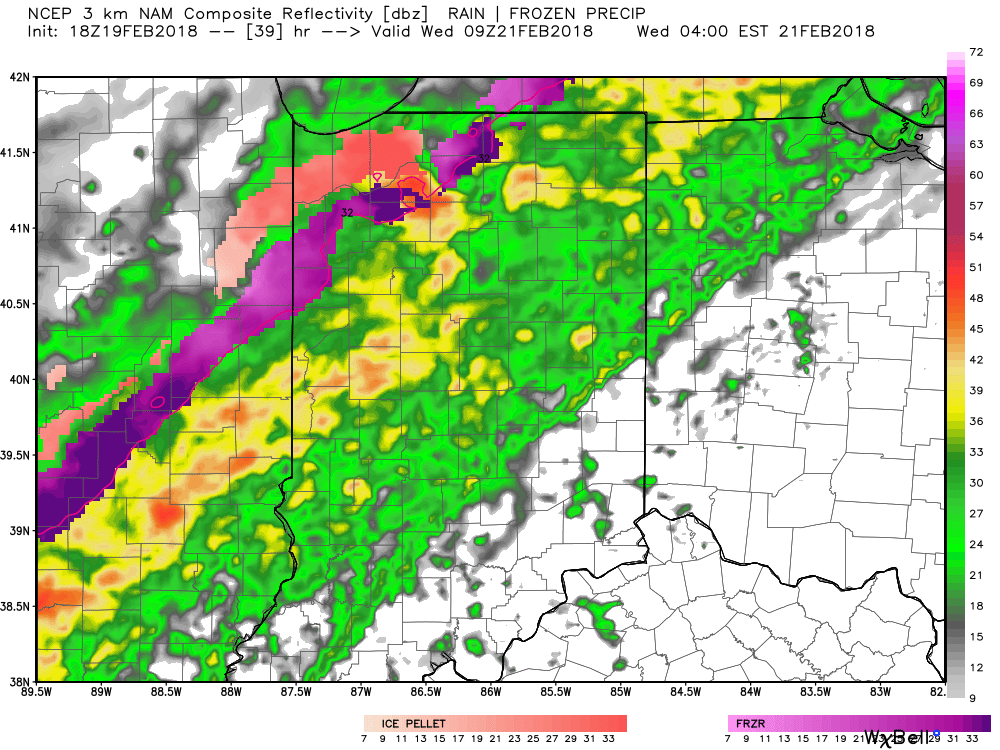
Heavier rain will overspread central Indiana late Tuesday night into Wednesday morning as the cold front settles south.

Forecast radar 4a Wednesday.
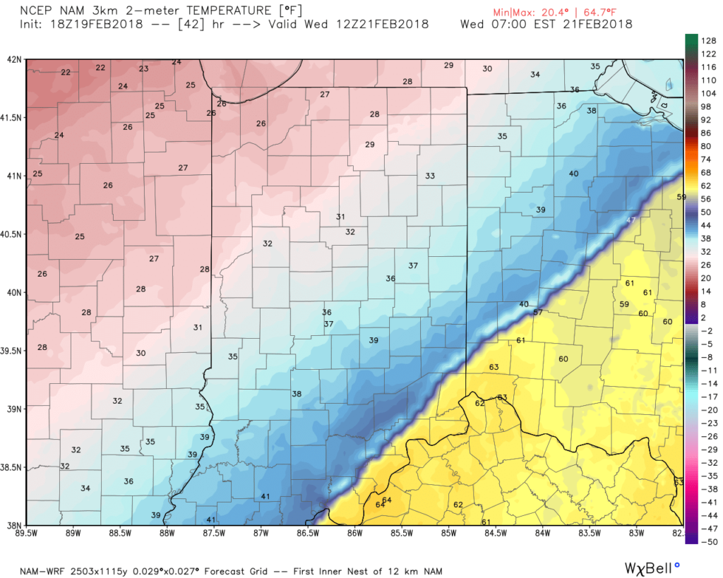
As the front continues to sink south, much colder air will quickly overspread the area. By the rush hour, many neighborhoods north of Indianapolis will already be around freezing. As moisture continues to stream northeast, areas of freezing rain will be possible on elevated and exposed surfaces Wednesday morning into the afternoon hours. With the recent warm, wet conditions, we don’t expect significant travel issues across central Indiana.
 After a quieter time of things most of Thursday, we’re tracking three additional waves of moisture Friday and through the weekend. At times, rain will be heavy, and we’ll certainly have to be on guard for water rise and increasing flooding issues as the weekend arrives.
 By the time all is set and done Monday morning, we forecast additional widespread 3.5″ to 5″ rainfall totals with locally heavier amounts.
Permanent link to this article: https://indywx.com/near-record-warmth-more-heavy-rain/
Feb 24
Severe T-storms This Evening Give Way To Much Colder Air This Weekend…
 Highlights:
- Record warmth
- Severe t-storm potential this evening
- Scattered snow showers Saturday
- Active pattern next week
Focused On Severe Weather This Evening…Though the day is beginning on a quiet note, we’re concerned it might not end that way, as strong to severe thunderstorms impact central Indiana this afternoon and evening. The sunshine this morning is actually something that adds further concern for the potential of explosive thunderstorm development later today. More specifically, we’re bracketing the hours of 4p and 10p for the likelihood of storms impacting central parts of the state (west to east), and some of these may become severe. All modes of severe weather are in play today, including large hail, damaging winds, and a tornado or two. Please have a means of getting the latest warning information and ensure you know your family’s severe plan. Otherwise, we forecast to shatter the record high today as we zoom all the way into the middle 70s with a gusty southerly wind.
Winter will return with authority tonight and set-up a much colder weekend. That high in the upper 40s Saturday will actually come at midnight with falling temperatures (most of the daytime hours will feature low-mid 30s with ‘chills in the 20s), windy conditions, and scattered snow showers.
A weak weather system is looking less and less impressive for the second half of the weekend, but we’ll continue to keep a chance of light rain in our forecast by evening.
Better rain chances will begin to ramp up Monday evening and become widespread Tuesday, including the possibility of thunderstorms, as well. The second half of next week will trend colder…
Upcoming 7-Day Precipitation Forecast:
- Snowfall: Trace
- Rainfall: 0.50″ – 1.00″
Permanent link to this article: https://indywx.com/severe-t-storms-this-evening-give-way-to-much-colder-air-this-weekend/
Feb 22
Active Pattern Ramping Up; Monitoring Multiple Storm Chances…
 Highlights:
- Spring-like air continues
- Severe t-storm potential Friday PM
- Much colder weekend
- Another round of strong-severe storms next week?
Buckle Up For A Wild Ride…Morning fog (some very dense, especially north of the city) will burn off and give way to increasing sunshine today, along with unseasonably warm temperatures. In fact, we’ll be near-record territory (Indy’s record high today is 70° and we forecast to tie that record this afternoon). We’ll remain near record territory over the next couple of days, but our attention will, unfortunately, have to shift from the record warmth to strong-severe thunderstorm potential.
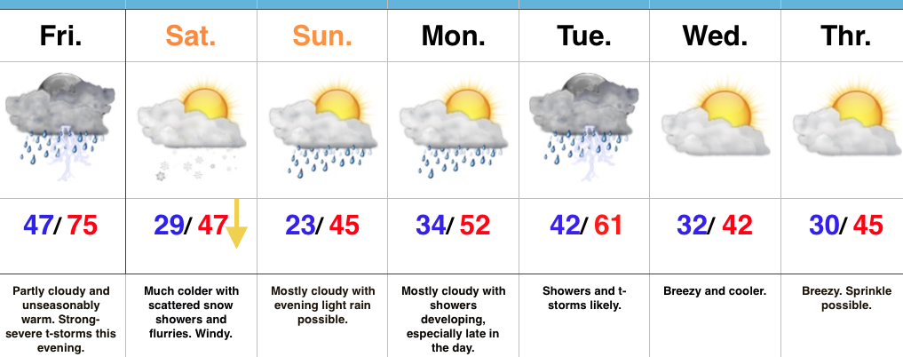
Most of Thursday will be dry, but a few scattered showers will likely dot the central IN landscape by the evening hours. Similar to Thursday, most of the day Friday will also be dry. It’s not until we head into Friday evening and night that we’re concerned for thunderstorms tracking through the state. A few of these storms will likely reach severe levels. Large hail and damaging winds are of greatest concern with the severe thunderstorms that develop. The cold front will sweep the state Friday night and a midnight high Saturday morning in the upper 40s will crash (most of the daytime will feature temperatures in the 30s with wind chills in the 20s) and wind-whipped snow flurries can be expected.
A weak weather system is still expected late Sunday and could feature a light rain and snow mix (not a big deal). What will be a bigger deal is a much stronger storm system rolling through the Mid West early next week. Unfortunately, another round of strong to severe thunderstorms will be possible Tuesday…
Upcoming 7-Day Precipitation Forecast:
- Snowfall: Trace
- Rainfall: 1.00″ – 1.50″
Permanent link to this article: https://indywx.com/active-pattern-ramping-up-monitoring-multiple-storm-chances/
Feb 17
VIDEO: Spring-Like Weekend…
You must be logged in to view this content. Click Here to become a member of IndyWX.com for full access. Already a member of IndyWx.com All-Access? Log-in here.
Permanent link to this article: https://indywx.com/video-spring-like-weekend/
