Grab The Jacket!
 Highlights:
- Harvey’s remnants
- Windy and October-like
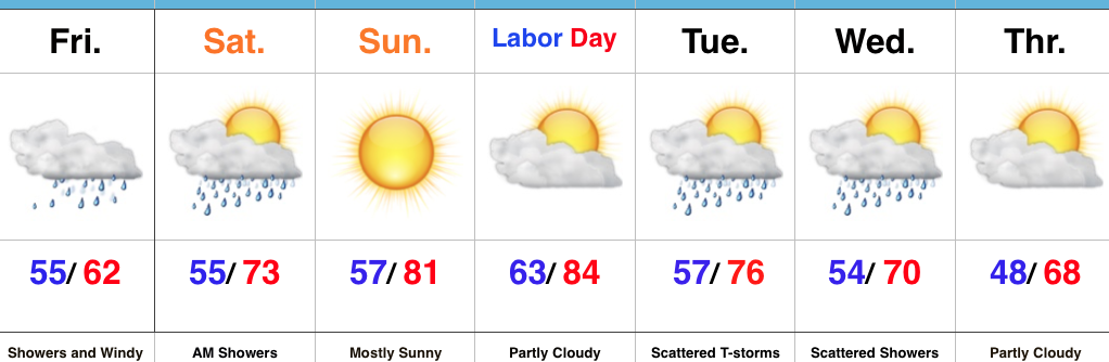
- Improving weather for Labor Day weekend
- Another blast of cool air next week
Is It The First Of September Or October?! Harvey’s remnants will track northeast along the Ohio River (tonight) and into the central Appalachians (Saturday). The combination of a tight pressure gradient between the circulation around what’s left of Harvey and an area of high pressure over the eastern Great Lakes will result in strong and gusty easterly winds to wrap up the work week. Factor in temperatures that will run close to 20° below normal and jackets will be required today! We don’t have any changes in regards to our rainfall forecast: heaviest and steadiest rain will remain downstate. Lighter showers will begin to overspread central parts of the state, including Indianapolis, later this evening.
Early showers will pull off to the east Saturday and we should end the day with increasing sunshine. Those improvements will continue Sunday into Labor Day with dry conditions.
A cold front will approach early next week and result in an increasingly windy regime Monday afternoon into Tuesday. The front will sweep through the state Tuesday with a broken band of showers and thunderstorms followed by another shot of unseasonably cool air by the middle of next week. Lingering upper level energy will result in spotty showers Wednesday with the cooler conditions.
Upcoming 7-Day Precipitation Forecast:
- Snowfall: 0.00″
- Rainfall: 0.30″ – 1.00″
 Highlights:
 Highlights: