Category: Rain
 Highlights:
- Windy times
- Cooler air arrives
- Showers Thursday night
- Chilly finish to the week
A cold front swept through the region Monday evening with a band of showers and embedded strong thunderstorms across the eastern portion of IN. Rainfall amounts weren’t impressive, unfortunately. High pressure is now building in and will result in a much cooler and continued dry time through mid week.
A secondary cold front will blow into town Thursday evening with scattered showers and MUCH cooler, breezy conditions to wrap up the work week. A chilly weekend is in store with frost potential Sunday morning.
Upcoming 7-Day Rainfall Forecast: Trace- 0.10″
Permanent link to this article: https://indywx.com/one-two-punch-of-cool-air/
 Highlights:
- Windy and warm open to the work week
- Cooler times coming
- Stronger front to close the week
- Weekend frost potential
We’ll welcome a new work week with blustery SW winds (gusting upwards of 30 MPH Monday afternoon) and warm conditions. A cold front will move through central IN Monday evening and cooler air will follow. We’ll turn much cooler for mid week, along with pleasant skies.
A secondary (stronger) front will sweep through the area Friday. This frontal system may include a couple showers, but the strong and gusty winds and MUCH cooler air will be the bigger deal. Dry skies, but well below normal temperatures are on tap this weekend. Many communities will be dealing with their first frost and/ or freeze come Sunday morning.
Upcoming 7-Day Rainfall Forecast: Trace- 0.10″
Permanent link to this article: https://indywx.com/a-warm-wind-monday/
 Highlights:
- Mostly dry theme continues
- Get used to the term “breezy!”
- Much cooler air coming
We couldn’t have asked for better weather for a Saturday and, thankfully, we’ll experience a repeat tomorrow (tack on a few degrees for afternoon highs). Breezy SW winds (gusts upwards of 30 MPH) will kick temperatures up to near 80 Monday afternoon before a cold front sweeps through the region Monday night. While an isolated shower is possible Monday, most of central IN will remain rain-free. Cooler air will arrive Tuesday and Wednesday.
A stronger cold front will move into the region Friday. Like our early week front, this one, too, will be moisture-starved. Windy conditions and MUCH cooler air will be the big deal going into next weekend. Most communities will experience their first frost Saturday and/ or Sunday morning.
Upcoming 7-Day Rainfall Forecast: Trace to 0.10″
Permanent link to this article: https://indywx.com/winds-of-change/
A cold front will pass through central IN early this afternoon. As expected, most of the region will experience a dry frontal passage (FROPA). Latest high resolution short term model…
You must be logged in to view this content. Click Here to become a member of IndyWX.com for full access. Already a member of IndyWx.com All-Access? Log-in here.
Permanent link to this article: https://indywx.com/friday-weather-notebook-2/
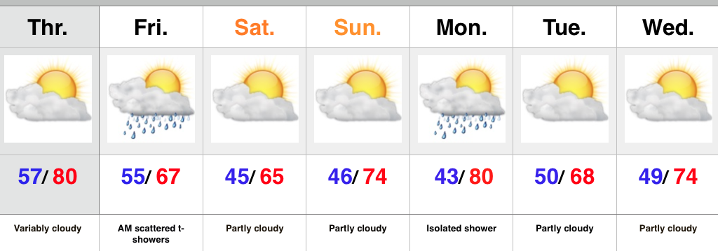 Highlights:
- Warm Thursday
- Cold front swings through Friday
- Great fall weekend coming
Thursday will feature another round of morning fog across central IN, but should be less widespread than the previous couple mornings. A southwest wind ahead of an approaching cold front will help boost temperatures up close to 80 this afternoon. As the front moves in Friday a broken band of showers and embedded thunder will accompany it. We’re not talking a lot of rain Friday, and the cooler air will be the bigger deal as we wrap up the work week and head into the weekend.
Another front will swing through the area Monday afternoon and evening. Ah, the “ups and downs” of fall will remain prevalent throughout the upcoming seven days…
Upcoming 7-Day Rainfall Forecast: 0.10″
Permanent link to this article: https://indywx.com/warm-thursday-with-a-cooler-open-to-the-weekend/
