VIDEO: A Cold Weekend Is On Tap; Looking Ahead To Thanksgiving Week…
You must be logged in to view this content. Click Here to become a member of IndyWX.com for full access. Already a member of IndyWx.com All-Access? Log-in here.
You must be logged in to view this content. Click Here to become a member of IndyWX.com for full access. Already a member of IndyWx.com All-Access? Log-in here.
You must be logged in to view this content. Click Here to become a member of IndyWX.com for full access. Already a member of IndyWx.com All-Access? Log-in here.
 Highlights:
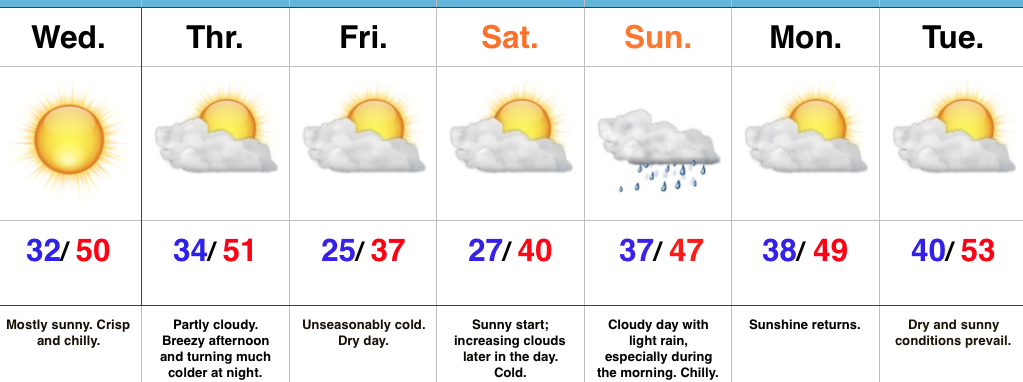
Coldest Air Of The Fall On Deck…High pressure is building in and will dominate our midweek weather, including sunshine and unseasonably cool temperatures. We’ll add a gusty breeze into the mix Thursday afternoon as an early season arctic front approaches. Once that front passes by Thursday night, a much colder air mass will plunge into the region. If your travels take you north Friday, snowbelt regions can expect snow showers and embedded squalls as the early season arctic air helps ignite the lake effect machine. Our first average high of 37° is on December 20th, so we’ll be running well ahead of schedule Friday. Bundle up!
After a bright and sunny start Saturday, clouds will begin to increase during the afternoon and thicken up overnight as our next storm system approaches. That storm system will deliver light rain Sunday. Sunshine returns to kick off the new work week along with slightly below normal temperatures.
Upcoming 7-Day Precipitation Forecast:
You must be logged in to view this content. Click Here to become a member of IndyWX.com for full access. Already a member of IndyWx.com All-Access? Log-in here.
 Highlights:
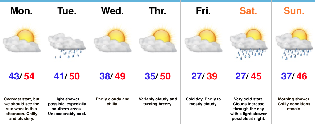
Have The Jackets And Coats Handy…After a rough Sunday filled with flooding and severe weather, we’re opening the work week on a much quieter, albeit much colder, note! An overcast start to the day should gradually give way to increasing afternoon sunshine. We’ve already experienced our high for the day (at midnight) and temperatures for most will remain in the 40s today, coupled with a brisk north breeze.
Our next weather maker will pass to our south Tuesday and this could spread a light shower as far north as central Indiana early Tuesday morning. Better rain chances will remain across southern portions of the state, but even here rainfall amounts will remain light.
Dry, unseasonably chilly conditions will prevail for midweek before a stronger blast of chill pushes in to close the week. This air mass will be of arctic origin and deliver the coldest temperatures so far this autumn. A hard freeze is expected Friday and Saturday mornings. Moisture will return over the weekend with light rain possible Saturday night into Sunday.
Upcoming 7-Day Precipitation Forecast: