VIDEO: Frigid Times “Moderate;” Looking Ahead…
You must be logged in to view this content. Click Here to become a member of IndyWX.com for full access. Already a member of IndyWx.com All-Access? Log-in here.
You must be logged in to view this content. Click Here to become a member of IndyWX.com for full access. Already a member of IndyWx.com All-Access? Log-in here.
2018 has opened on an absolutely frigid note. Indianapolis is running an amazing 11° below average through mid-month.
 Eight mornings so far this winter have plunged below zero. We’ll see if we can add another to that list this morning (IND is officially at 0° as we write this).
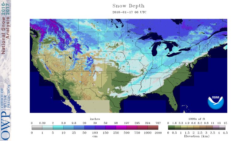
52% of the country is covered in snow. In fact, my old stomping grounds of Auburn, AL received 3″ of the white stuff overnight!
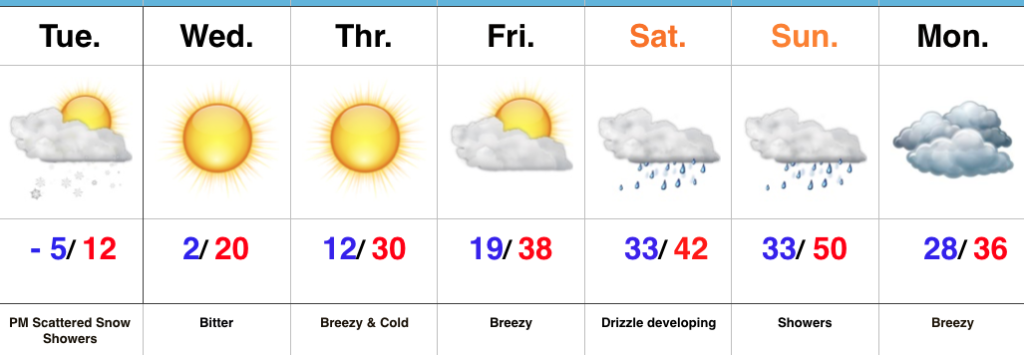
 If you’re sick and tired of the cold, wintry conditions relief is on the way. We’ll turn “less cold” through late-week and above normal over the weekend (around 40° Saturday and into the upper 40s Sunday).
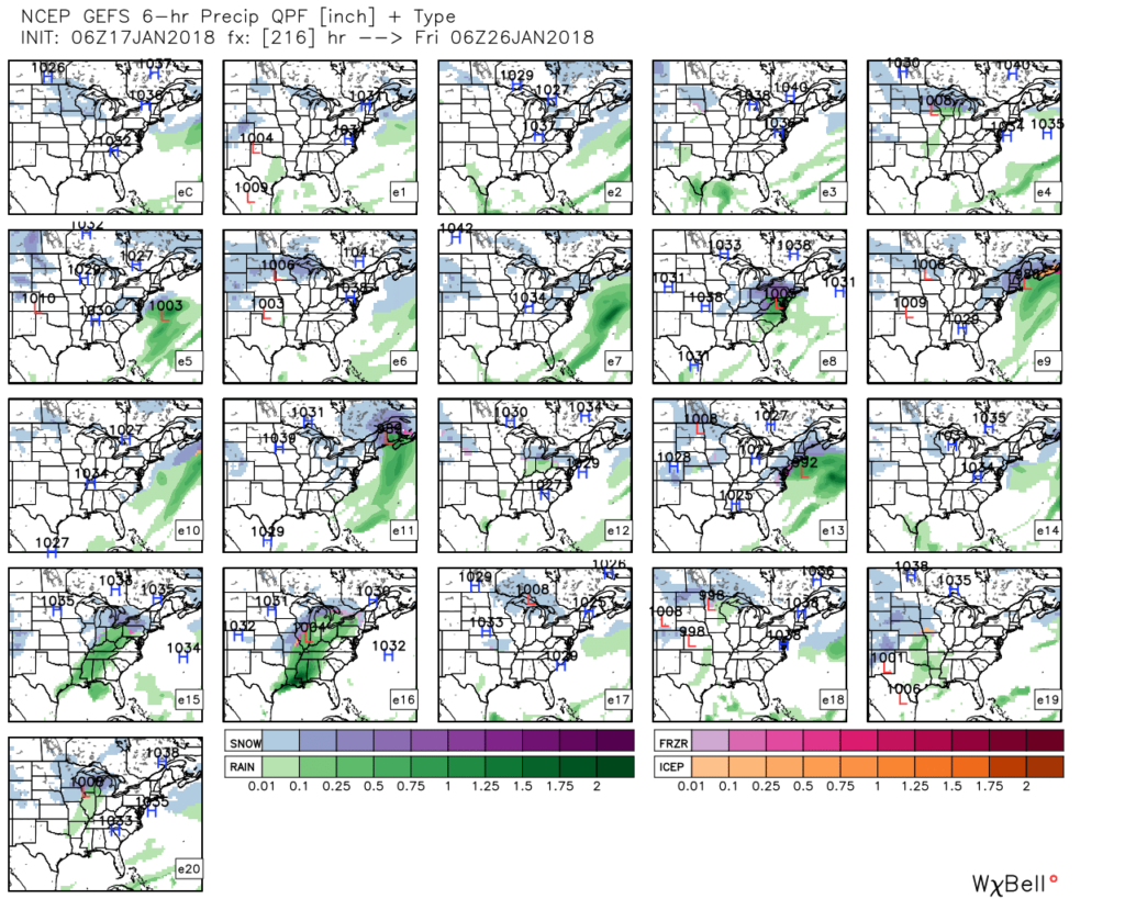
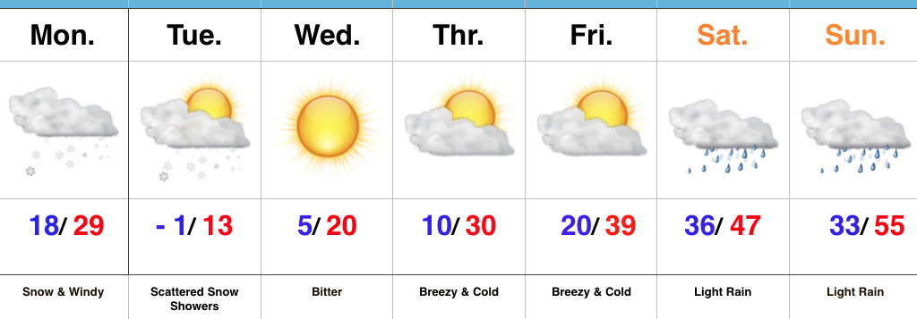
 A storm system will cut into the ridge Sunday with showers (image 1) followed by “backlash” snow showers and gusty winds Monday (image 2).

 Thereafter, models see another storm that will approach the region late next week. Since cold air won’t be readily available, it’ll take the perfect track to get impactful wintry conditions from this next event. We’ll monitor things closely next week. With this near Day 10, models will continue to struggle with timing, track, and intensity over the next few days.
 As a whole, the second half of January should run milder than average. However, as we all know, that doesn’t mean we won’t have wintry challenges to deal with. The upcoming (10) days illustrates that nicely. Looking ahead, we note the MJO is forecast to rumble through the warmer phases (especially if you’re reading this from the eastern regions of the country- where we expect warmth to be most anomalous into early February).

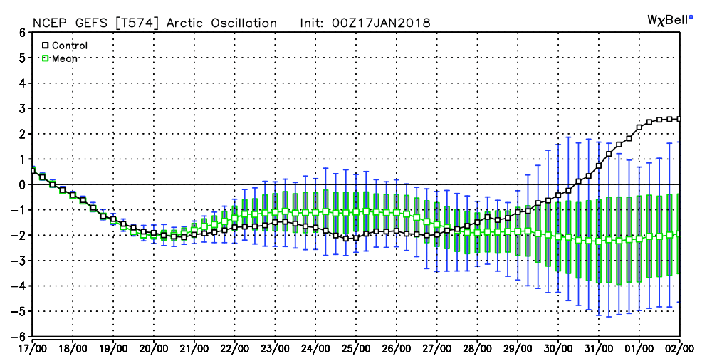
 Other teleconnections also support a relaxation of the cold, and warmer times, overall, with the exception of the Arctic Oscillation which remains negative through the period.
 It should be noted that the longer range data and overall trends, supported by our analogs, suggest winter roars back with authority as we get into February. In fact, winter might not be so quick to leave this year either. Data paints a cold, wintry open to meteorological spring this year, but we’re getting way ahead of ourselves. It is only mid-January, after all. 🙂
 Highlights:
Bitter, Bitter…Arctic high pressure will dominate our weather through the early and mid week stretch. We note high resolution modeling trying to swing a couple bands of light lake effect snow through north-central Indiana later this afternoon and evening and we’ll continue to keep snow showers in our forecast for this reason. Otherwise, cold is the story today. We’re starting our Tuesday adding yet another sub-zero low to the already impressive list this winter. Cold continues Wednesday before beginning to turn “less cold” through late week.
Our next storm system will approach this weekend. As low pressure tracks into the Great Lakes, a milder southwesterly flow will allow temperatures to zoom all the way up close to 50° by Sunday. Fog and drizzle will develop Saturday before “showery” and breezy conditions build in ahead of the front Sunday.
Upcoming 7-Day Precipitation Forecast:
 Highlights:
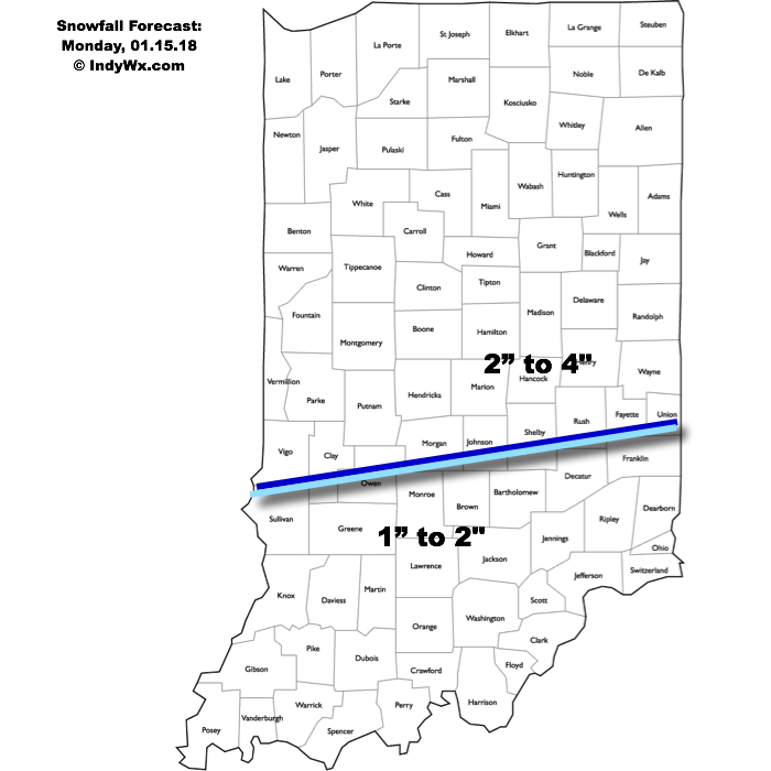
Snowy Open To The Week…A vigorous clipper system and associated arctic cold front will drop southeast and spread a swath of snow across the region tonight into Monday. We expect light snow to encompass most of central Indiana later this evening (between 7p and 10p west to east) before increasing in overall intensity during the overnight. Periods of moderate to heavy snow can be expected during the mid-morning hours Monday, including impressive snowfall rates at times. Allow plenty of extra time to reach your destination Monday. Steady snow will give way to scattered snow showers during the afternoon, continuing into Tuesday as fresh arctic air pours into the region. By the time all is said and done, most of the region can expect a fresh 2″ to 4″, including some locally heavier totals. The other item on the agenda will be blowing and drifting snow that we’ll have to deal with Monday afternoon through the night and into Tuesday.
Arctic high pressure will settle overhead Tuesday night through the midweek stretch, allowing sunshine to return, but we’ll remain well below average (average temperatures this time of year include highs in the mid-30s and lows around 20).
A moderating trend takes place late week, but the “less cold” air will come with gusty southwesterly winds and increasing clouds Friday. Those clouds will give way to periods of rain along with milder conditions over the weekend as an area of low pressure tracks into the Great Lakes.
Upcoming 7-Day Precipitation Forecast:
 Highlights:
Active Forecast Period…A breezy southerly flow will dominate our weather today ahead of an approaching cold front. Showers and unseasonably mild conditions can be expected today. (Despite the snow lover in me, I will admit that it’s been mighty nice being able to jog outside without worrying about slipping on ice or snow the past couple days).
Things begin to change in rather dramatic fashion tonight as the cold front presses through the state and allows much colder air to “ooze” back into central Indiana. At the same time, a wave of energy will track northeast along the cold front and help spread more widespread moisture into the colder air at the surface. We expect rain to begin mixing with and changing to an icy mixture of sleet and freezing rain after midnight across western and central portions of the state, and closer to 5a-6a across eastern Indiana. Eventually, as the entire column of air cools, icy precipitation will transition to snow. If the sleet to snow transition occurs faster, snowfall totals will be at the higher end of the first call numbers outlined below. Should sleet hold on for a longer period of time, snowfall amounts will be on the lower end of forecast totals. We think snow will end around noon west of the city, but steady snow will hang on much longer across eastern sections of the viewing area- well into the evening hours.
Here’s our first call snowfall forecast for Friday. While this doesn’t include freezing rain amounts, we think a glaze up to 0.10″ is a good bet – especially on elevated and exposed surfaces.
 Dry conditions will return Saturday along with a much colder feel. Quiet times won’t last long as another snow system will quickly begin to impact the state Sunday evening into Monday. Widespread steady snow is expected to develop and will actually be a more uniform, bigger, event for most of the viewing area. We’ll add in wind and arctic air which will lead to blowing and drifting issues as the day progresses Monday into Tuesday. Here’s our first call for additional snow amounts Sunday evening-Monday.
 The forecast period will wrap up dry and bitterly cold. With a fresh snowpack down, it’s safe to say we’ll add at least another night to the sub-zero “club!”
Stay tuned, friends!
Upcoming 7-Day Precipitation Forecast:
*Please note the 7-day precipitation forecast outlined above is for Indianapolis proper.