Updated 03.18.22 @ 7:40a
You must be logged in to view this content. Click Here to become a member of IndyWX.com for full access. Already a member of IndyWx.com All-Access? Log-in here.

Mar 18
Updated 03.18.22 @ 7:40a
You must be logged in to view this content. Click Here to become a member of IndyWX.com for full access. Already a member of IndyWx.com All-Access? Log-in here.
Permanent link to this article: https://indywx.com/video-keeping-an-eye-on-severe-potential-tonight-looking-ahead-to-an-active-close-to-the-month/
Mar 16
Updated 03.16.22 @ 6:42a
While relative warmth will dominate headlines in the short-term, there’s plenty of reason not to buy into the idea that we’re finished with the chilly late winter temperatures just yet.
First, let’s start with the MJO. We’re in Phase 2 now, but what is most intriguing is the duration spent in Phase 3 (favors a pressing trough east and south similar to what image 2 shows below).
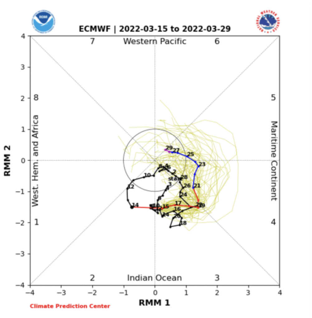
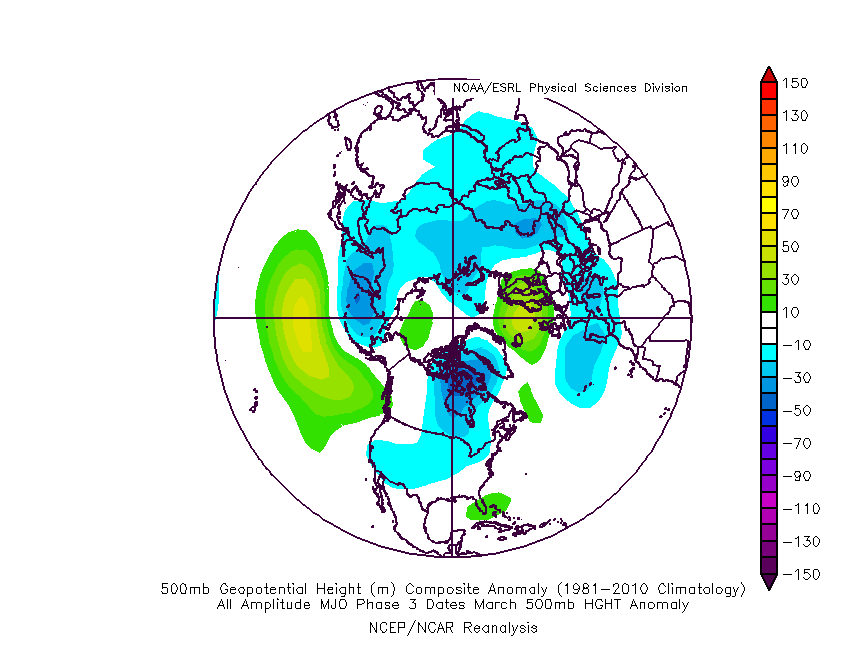
Should the MJO continue to move forward with similar amplitude then milder conditions would prevail as we get set to wrap up the month.
By that point, however, we’ll have to pay particularly close attention to the EPO and NAO phases. There are growing signals that both teleconnections will favor a return of colder than normal conditions prior to closing out the month. Couple that with the MJO movement and confidence continues to increase that we aren’t quite finished with the chill just yet. The question then becomes what takes place in April? We’ll lean into that with more detail during tomorrow’s update.
Permanent link to this article: https://indywx.com/chill-isnt-finished-yet/
Mar 12
Updated 03.12.22 @ 8:36a
While we’re waking up to absolutely bitter conditions this morning (especially by mid-March standards), a significant pattern change awaits this week. Temperatures this morning are deep into the 10s and include ‘chills in the subzero category.
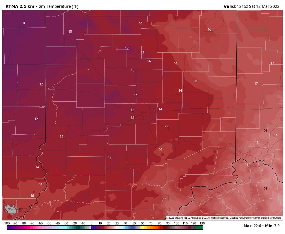

Most across central Indiana will struggle to make it above the freezing mark today, but have no fear. Strong moderation kicks into high gear for the 2nd half of the weekend. That will lay the groundwork for our trend in the week ahead. Ridging will expand across the eastern portion of the country and result in temperatures climbing into the upper 60s by midweek.

Aside from a couple light showers Tuesday, our weather conditions look rather uneventful until late next week when a more organized storm will push better rain chances into our picture to close out the work week.
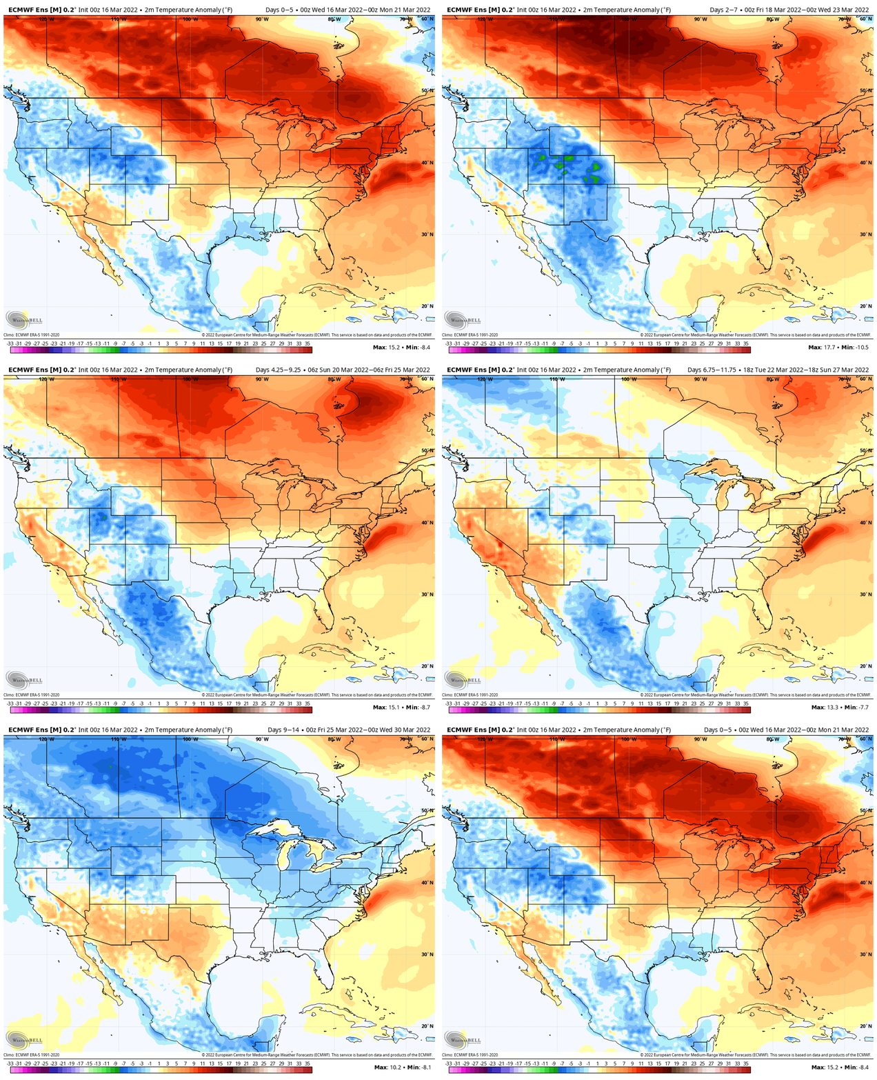
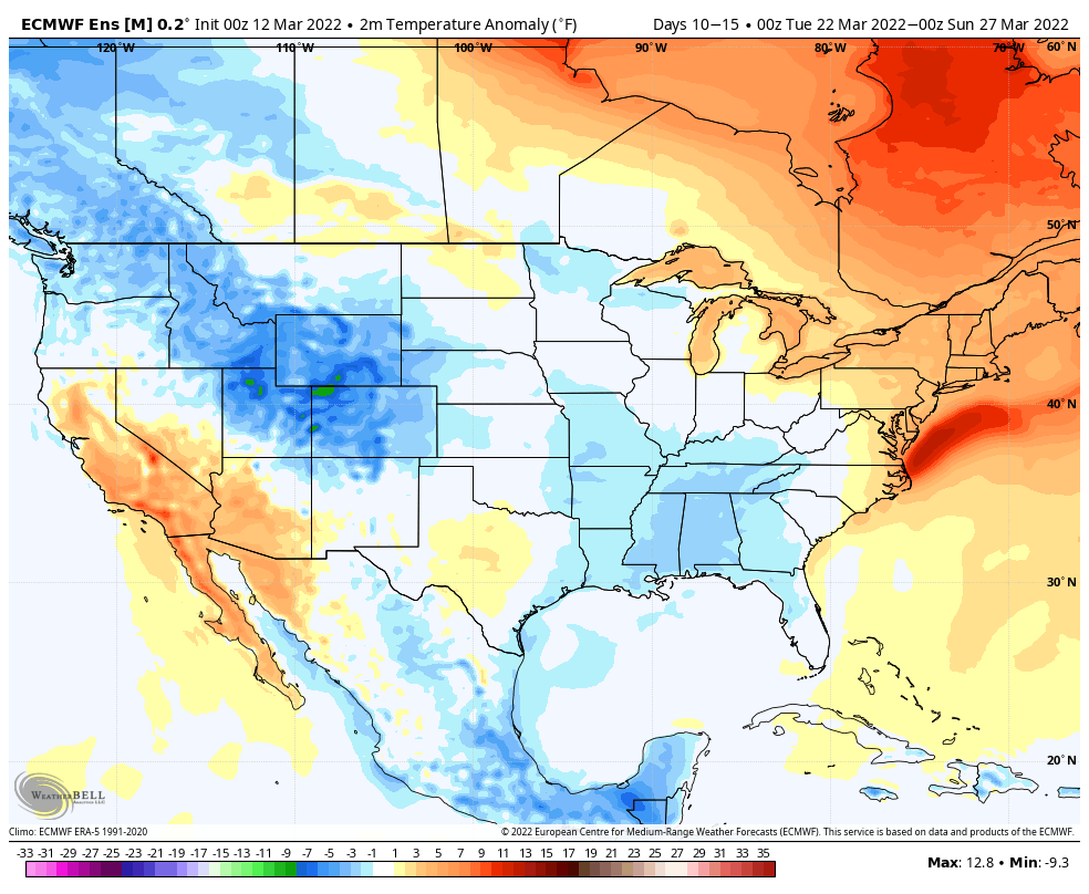
Looking ahead, you can begin seeing the reflection in the European ensemble (above) of a central and eastern trough developing, yet again, as we get set to close out March. This is likely a byproduct of an expected negative EPO and NAO late month and reason to tap the brakes on any idea of a “stick and hold” spring pattern just yet.
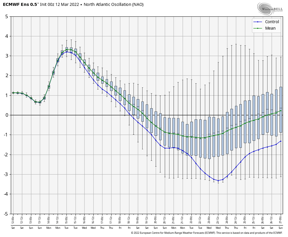

The idea here is that we close things out this month on a chillier and wetter note (compared to normal) and should watch for the potential of anomalies to grow even colder as we go through time- especially if we drive that NAO and EPO even deeper into the negative territory.

Permanent link to this article: https://indywx.com/significantly-milder-in-the-week-ahead-but-not-ready-to-make-claim-spring-is-here-to-stay/
Mar 10
Updated 03.10.22 @ 7:20a
You must be logged in to view this content. Click Here to become a member of IndyWX.com for full access. Already a member of IndyWx.com All-Access? Log-in here.
Permanent link to this article: https://indywx.com/video-jab-of-late-season-arctic-air-ahead-of-a-much-milder-week-long-range-update-into-late-month/
Mar 02
Updated 03.02.22 @ 7:56p
The Madden Julian Oscillation (MJO) is back in the null, or neutral, phase.

That means it’s time to start leaning heavier on the teleconnection blend. This time of the year, that encompasses all, including the NAO.
As we look over the course of the upcoming 10-14 days, we note rather strong alignment between the teleconnections favoring a return of a cold pattern. That is, of course, after the taste of spring that will continue into the day Sunday (aside from one “speed bump” tomorrow).
We note the EPO, or East Pacific Oscillation, is forecast negative until around the 12th and then back towards neutral. This is a cold signal for the east, relative to average.
The NAO (North Atlantic Oscillation) is forecast neutral through the bulk of the upcoming couple weeks. – Likely won’t have a significant impact on the overall pattern.
The PNA (Pacific North American pattern) is forecast negative through the 13th before trending neutral. This should allow a southeastern ridge to remain in play to at least some degree which suggests a very active storm track into the Ohio Valley. As the colder air pushes east and runs up against the resistance from the southeastern ridge, late season wintry threats loom towards mid month.
Finally, the WPO (West Pacific Oscillation) is forecast strongly negative which also implies cold should try and fight east.
With all of that said above, we note the ensemble guidance (both the EPS and GEFS) brings the trough back into the central and eastern portion of the country as we move out of the Day 1-6 period and suggests it’s far too early to think about putting away those winter clothes, or even the snow removal equipment just yet…


Note the colder than normal temperatures spilling back into the region next week and the week beyond.

We’re likely far from finished with snow or wintry precipitation either…

Permanent link to this article: https://indywx.com/winter-isnt-done-yet/