Category: Monthly Outlook

June 2020 Outlook: “Transient” Is The Word…

The first month of meteorological summer is here and right on cue, we’re expecting a significantly warmer pattern to emerge. Does that set the tone for the month as a whole? In the words of Lee Corso: “not so fast my friend.”

After a refreshing weekend the first week of June, overall, is expected to be dominated by a MUCH warmer and more humid pattern. This is courtesy of an upper level ridge building east over the region (in response to the MJO moving into Phase 1, along with a strongly positive EPO).

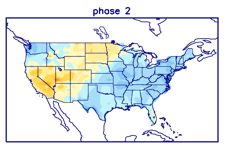
Deeper into the month, it’ll be tough to hold onto this warm, humid regime as the EPO trends negative and the MJO shows signs of rumbling into Phase 2. In the month of June, Phase 2 delivers cooler than normal temperatures into our portion of the country, along with a good chunk of the East.

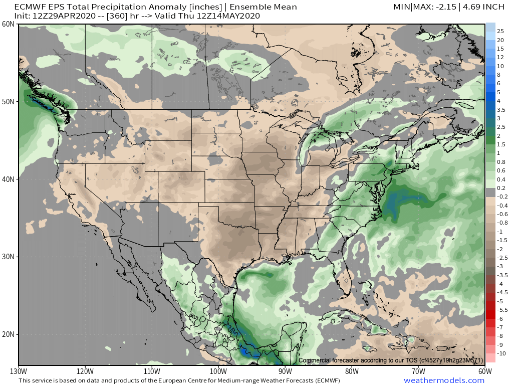
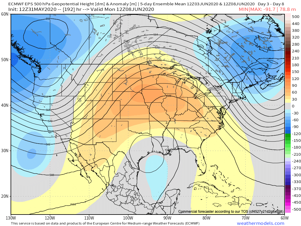
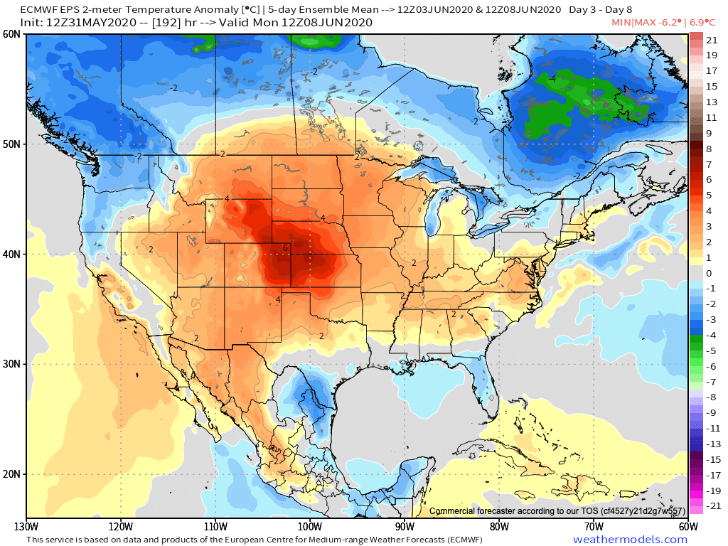
Sure enough, the latest European computer model is seeing this cooler trend developing by Week 2:

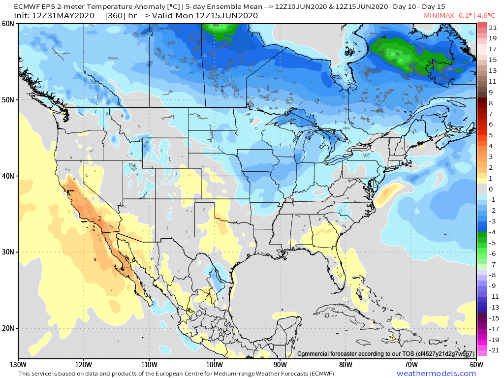
Given the longer range data, there’s reason to believe the cooler than normal temperatures will also be transient (similar to the warmth to open the month). Overall, drier than normal conditions are expected through the first month of meteorological summer. We’ll have to keep close tabs on where the drier pattern sets up as this can “feedback” on itself the deeper into summer we go.

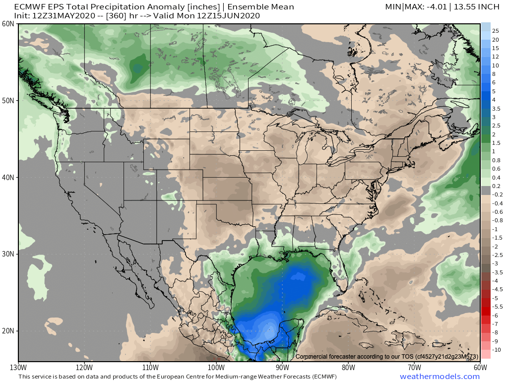
Given the MJO and EPO forecasts, there’s reason to buy into a “transient” pattern that June should dish out. After a drier than normal 1st half of the month, precipitation should average out close to normal by month’s end. The one exception to this will have to do where remnant tropical moisture tracks inland in the Week 2 time period. From this distance, there are 2 camps pertaining to the potential track of soon-to-be Cristobal: TX/ LA coastline or FL panhandle. The next 7-10 days will be interesting. We’d recommend getting used to an ever-changing temperature pattern in the upcoming 3-4 weeks that should balance out close to average for our neck of the woods by month’s end.

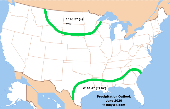
Our official June Outlook looks like this:

Permanent link to this article: https://indywx.com/june-2020-outlook-transient-is-the-word/

May 2020 Outlook: From One Extreme To The Other?

While a good chunk of the 1st half of the month likely features below normal temperatures, is there potential for a “sudden summer” flip in the pattern for the 2nd half of the month? Let’s discuss!

First and foremost, averages in May for Indianapolis feature lows rising from the upper 40s to the upper 50s by month’s end, highs increasing from the upper 60s to the upper 70s, and 5.05″ of rain. Of note, on average, May is the wettest month out of the year in Indianapolis.

Teleconnections are aligned in a manner to drive rather widespread and persistent cooler than normal anomalies across the eastern portion of the country through the better part of the 1st half of May. Note the positive PNA and negative EPO and associated upper air pattern.

A persistent eastern trough will deliver an extended period of below normal temperatures through the first couple weeks of the month.

As chilly Canadian high pressure builds south behind departing cold fronts, we’ll have to remain on guard for the threat of late season frost/ freeze conditions lingering into the middle of the month.

To no surprise, the cool Canadian air will be much drier than a “typical” May pattern that can occasionally tap into the Gulf of Mexico. Accordingly, the pattern should run drier than normal through the 1st half of the month.

While we’re confident on the cool, dry (relative to average) theme carrying the day through the 1st half, there will likely be a snap back in the pattern that will promote at least the threat of a “sudden summer” regime during the latter part of the month. Timing this adjustment will be a bit challenging, but we believe that’s on the table at some point late week 3 or week 4. Accordingly, we’re building our May Outlook to feature this warmer (to hotter) potential late month or else it would be even cooler across the East- overall.

We’ll, obviously, also have to keep close tabs on the MJO throughout the middle and latter part of the month for influences on the pattern.

Without further ado, here’s our May 2020 Outlook…

Permanent link to this article: https://indywx.com/may-2020-outlook-from-one-extreme-to-the-other/

VIDEO: The Sun Returns; Weekend Chatter And Updated Long Range Thoughts…

You must be logged in to view this content. Click Here to become a member of IndyWX.com for full access.  Already a member of IndyWx.com All-Access?  Log-in here.

Permanent link to this article: https://indywx.com/video-the-sun-returns-weekend-chatter-and-updated-long-range-thoughts/

April 2020 Outlook…

Average highs in April rise from the upper 50s early in the month to the upper 60s by late-April. We also tack on an average of 10° on overnight lows (upper 30s early on to upper 40s by late April) with 3.8″ of rain and an average of 0.2″ of the white stuff.

As we look at April 2020, there are growing indications for cooler and drier than normal conditions- at least during the 1st half of the month. A lot of this has to do with teleconnections finally aligning with one another (as opposed to all of the conflicting signals we dealt with throughout the bulk of the winter).

Additionally, the MJO is expected to move through Phases 4 and 5 over the next couple of weeks and this also is a cooler, drier look, overall for our portion of the country.

The majority of long range data is going to this cooler, drier look through the 1st half of the month.

JMA Weeklies Weeks 3-4
European Ensemble – Temperature Anomalies
European Ensemble- Precipitation Anomalies
GFS Ensemble- Temperature Anomalies
GFS Ensemble- Precipitation Anomalies
Canadian Ensemble- Temperature Anomalies
Canadian Ensemble- Precipitation Anomalies

With the guidance painting an overall cooler and drier than normal theme through the 1st half of the month, the question then becomes what takes place for the 2nd half of April? We’re thinking a rebound is ahead, including a more active, warmer period, but the timing of this shift is admittedly tough (does this take shape mid-month or the last week to 10 days of the month)? With a boiling warm Gulf of Mexico, the threat of an increasingly busy time of things in the severe weather department is also anticipated for late April. This, of course, is after what should be an unusually quiet time of things through the first half of the month.

With all of this in mind, here’s our April Outlook:

Permanent link to this article: https://indywx.com/april-2020-outlook/

March 2020 Outlook…

The majority of longer range models are bullish on a much warmer than normal month of March. Below you’ll see a snap shot of the latest JMA Weeklies, European Weeklies, and CFSv2. All are in relative agreement on a warm open to meteorological spring.

The other common theme? Strong signals for wetter, to much wetter, than normal conditions.

Note the first image of the JMA Weekly data is also leaning in the direction of wetter than normal conditions.

Indianapolis March “averages” include a low of 32.8°, a high of 51.7°, 3.56″ of rain, and 2.6″ of snow.

We’re leaning in the direction of a warmer than normal, wetter than normal month, as well. The reason? You guessed it- a predominantly positive EPO and the MJO that’s expected to rumble primarily through the warmer phases for this time of year.

We’ll tackle the latter first. Note the latest MJO plot takes things through Phases 4-5. Those are notorious warm phases in March as shown by the composite 500mb analogs below.

While the MJO plot above only goes out to mid-month, there are reasons to believe things won’t get into the cold phases and that we should cycle back into the warmer phases, or potentially remain in the “null” phase.

We’ll, of course, have to monitor the EPO for negative “jabs” that may try and take place, but think we’re looking at a predominantly positive EPO throughout the month. Additionally, the NAO (North Atlantic Oscillation) looks to also remain predominantly positive and this is also a warm signal for this time of year.

Accordingly, we’re leaning towards a warm, yet wet open to meteorological spring, including temperatures that should run 1° to 3° above normal across central Indiana.

Permanent link to this article: https://indywx.com/march-2020-outlook/