You must be logged in to view this content. Click Here to become a member of IndyWX.com for full access. Already a member of IndyWx.com All-Access? Log-in here.
Category: Long Range Discussion
Permanent link to this article: https://indywx.com/video-increasingly-active-wetter-pattern-to-close-out-june-and-open-july/
Jun 19
Timing Out Rain Chances Into Next Week; Sniffing Out The Early July Pattern…
You must be logged in to view this content. Click Here to become a member of IndyWX.com for full access. Already a member of IndyWx.com All-Access? Log-in here.
Permanent link to this article: https://indywx.com/timing-out-rain-chances-into-next-week-sniffing-out-the-early-july-pattern/
Jun 18
Long Range Update: Changes Afoot…
Looking at a simple snapshot of the latest sea surface temperature anomaly map would suggest a La Nina is brewing (image 1), BUT the latest SOI (Southern Oscillation Index, also knows as the SOI) suggests otherwise (images 2-3):
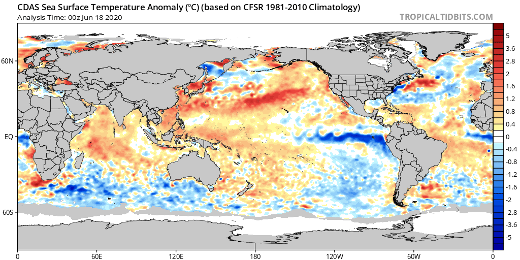
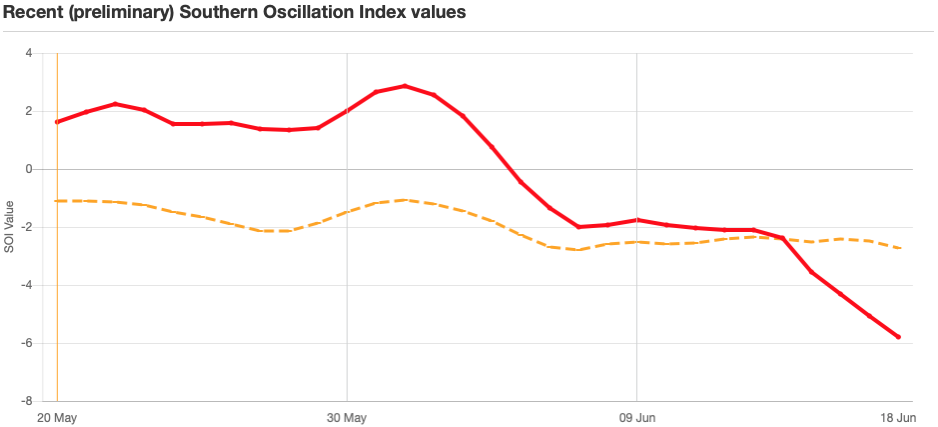
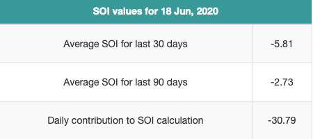
In fact, the SOI values noted would suggest an El Nino is coming on. The daily hit of more than 30 suggests some wild swings in the weather over the upcoming couple of weeks across the Lower 48. Now, we still anticipate this to transition more towards a positive direction and a subsequent La Nina to, indeed, develop by fall and winter, but this is worth continuing to pay attention to and we’ll do just that.
As we look at June to-date across central Indiana, temperatures are running a little more than 2° above normal and precipitation is just over 1″ below normal. Given the pattern ahead, we continue to like where we stand with our June forecast overall: near-average precipitation and temperatures. This will, obviously take a wetter, cooler shift in the regime as we move through the next 10-12 days. Overall, that’s where we continue to believe we’re heading.
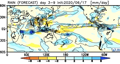
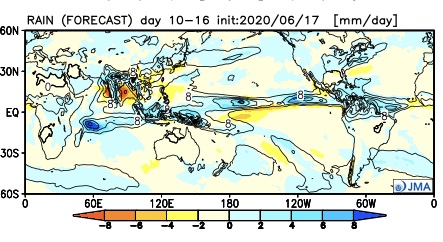
The latest JMA Weeklies hot off the press shows this big cool, wet change across our region. A series of troughs are shown to descend into the Ohio Valley during the next 10-16 days. As the individual cold fronts sweep through the region, better chances of rain will result and temperatures will run cooler than normal, overall.
Week 1

Week 2

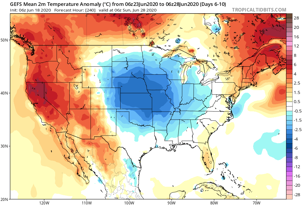
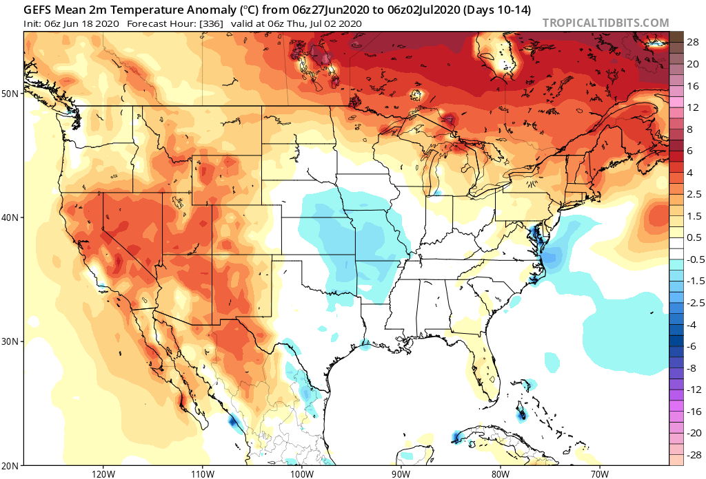
The latest GEFS data is very similar in this wet, cool shift.


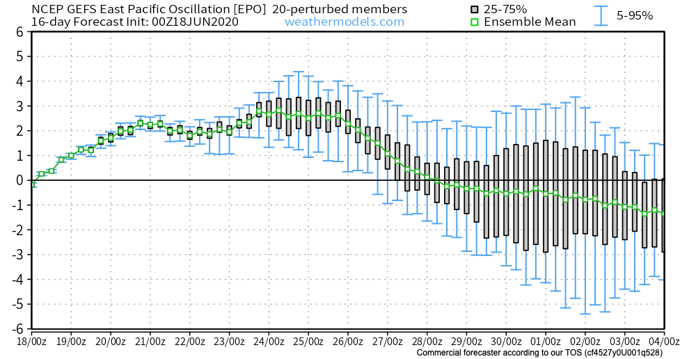
There’s support for this pattern in looking at the latest East Pacific Oscillation, as well. Negative values support central/ eastern cool and periods of transition from positive to negative (and vice-versa) also can help promote wet/ more active periods.
The MJO (Madden Julian Oscillation) is a “sneaky” wild card in all of this. Note how the MJO is currently shown to slowly move through Phase 2 before going into the wheelhouse and emerging into Phase 8 by month’s end. While certainly not highly amplified, this is enough to have impacts. Note that Phases 2 and 8 this time of year maintain a cooler look, locally.
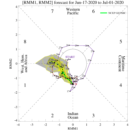


In summary, though it’s certainly been dry over the past couple of weeks, we think there’s more than enough reason not to fret. Not only are we looking at a pattern that should keep the heat (at least in a prolonged sense) west of our region, but the pattern drivers above should also result in a much more active regime with frontal passages and associated areas of low pressure moving through the region. This will begin in earnest early next week and continue through Week 2.
Permanent link to this article: https://indywx.com/long-range-update-changes-afoot/
Jun 12
Long Range Update: Timing Out When The Dry Pattern Breaks Down; 2nd Half Of Summer Chatter…
The balance of the upcoming 7-10 days will feature bone dry conditions across central Indiana. A fast moving disturbance will drop southeast Saturday and could spawn a scattered shower across central Indiana, but we believe the more concentrated rain activity will remain to our east and southwest. If you do see a Saturday shower, count yourself lucky! This disturbance and associated cold front will serve to reinforce the dry airmass currently in place, along with bring temperatures down another couple of “notches” for the weekend (wouldn’t be surprised if some outlying areas get into the 40s Sunday or Monday mornings).
As we look ahead, a ridge of high pressure will dominate next week’s weather pattern. An extended stretch of dry (pleasant humidity levels), sunny days can be expected with a slow warming trend.

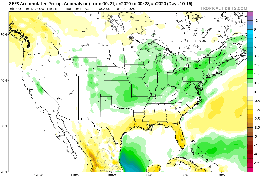
Things begin to get a little more “murky” late next week as forecast model solutions differ significantly. The new GFS forecast model drives a cold front into the Ohio Valley before stalling out as multiple disturbances ride along the boundary. This would lead to needed rain (and potentially heavy rain at that) late next week into next weekend. Meanwhile, the European model isn’t nearly as excited about this wet weather potential. The reality likely lies somewhere in between and we’ll trend our forecast wetter late week, but hold on the heavy rain threat for now. Stay tuned.
With that said, we do believe (given the pattern drivers discussed below) that the wetter trends shown on the GFS ensemble data in the Week 2 (and beyond) time frame has validity.

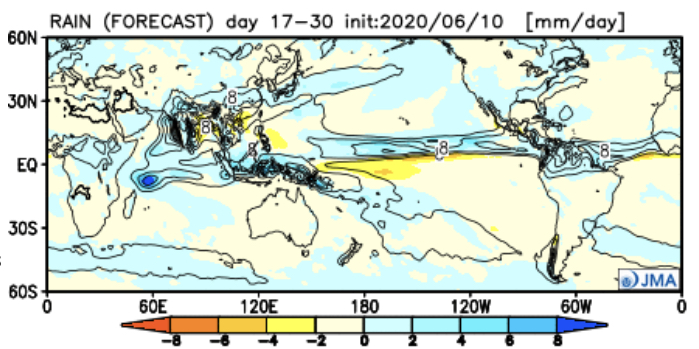
The latest JMA Weekly data also shows a similar wet idea during this time period.

As we look at the PNA and EPO, the transition in both teleconnections next week do give credence to the wetter them shown above during the said period.
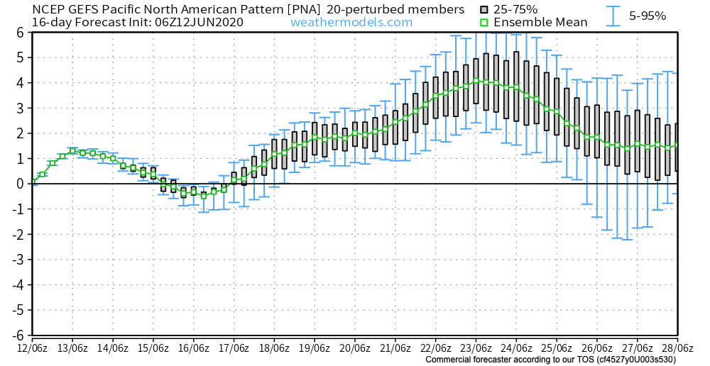
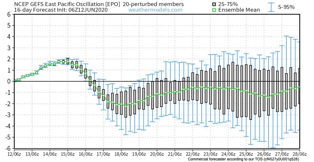
Additionally, the positive PNA (image 1 above) and negative EPO (image 2 above) argue for the possibility of another period of cool weather to wrap up the month. This would come after transitional heat late next week.
The GEFS is cooler than the European during this time frame. Given the above, it wouldn’t surprise us if the Euro is forced to cool as we get closer to this period.
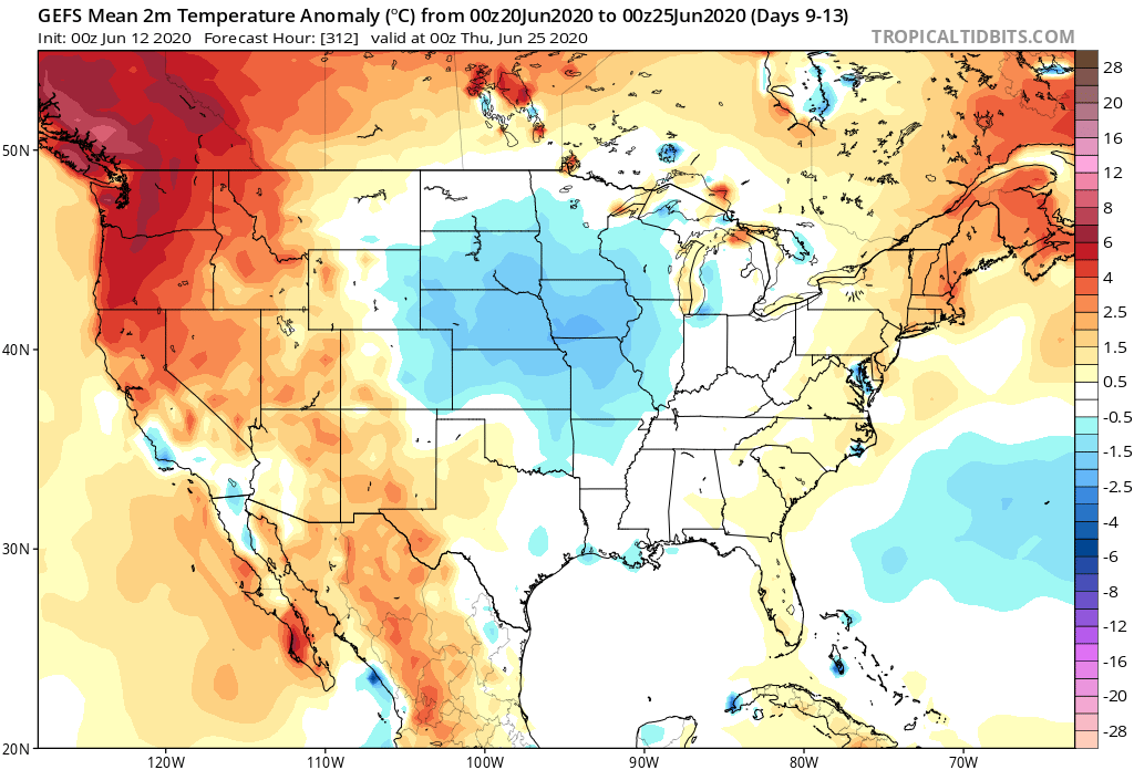
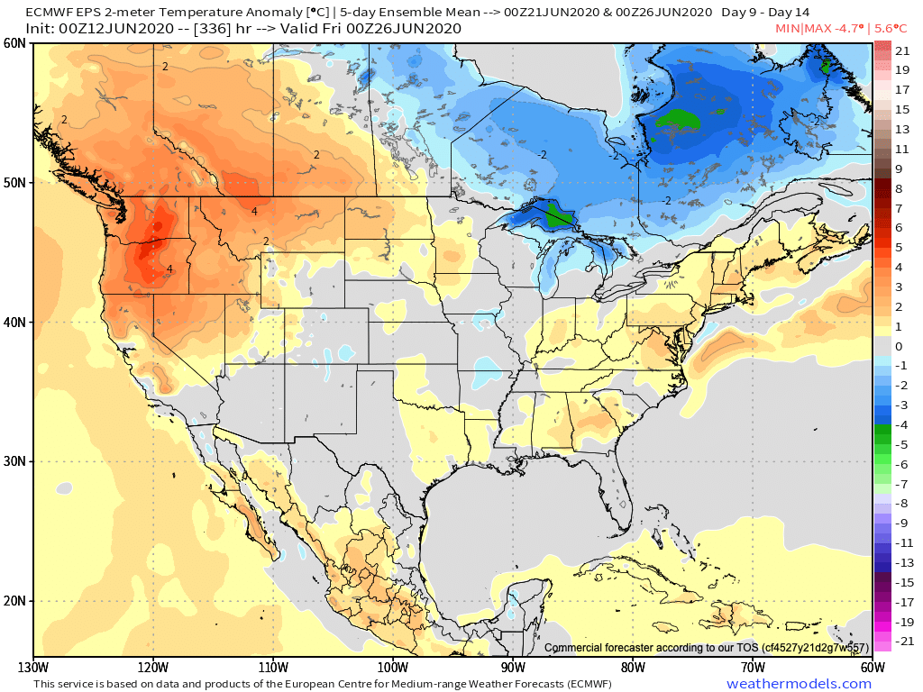
We’re undoubtedly entering into a critical time frame for the remainder of the summer. The upcoming couple of weeks will go a long way in determining the balance of the rest of this season. Despite the short-term dry pattern, we do believe (at least locally), rain will return before things get out of hand. The same may not be able to be said just to our west. It’s there (more from the Rockies into the Plains) where we think July heat will build in more significant fashion with the drier soils.
Permanent link to this article: https://indywx.com/long-range-update-timing-out-when-the-dry-pattern-breaks-down-2nd-half-of-summer-chatter/
Jun 09
VIDEO: Details On The Severe Threat This Afternoon/ Evening; Turning MUCH Cooler And Drier Late Week…
You must be logged in to view this content. Click Here to become a member of IndyWX.com for full access. Already a member of IndyWx.com All-Access? Log-in here.
Permanent link to this article: https://indywx.com/video-details-on-the-severe-threat-this-afternoon-evening-turning-much-cooler-and-drier-late-week/
