Threat Of Another Major Winter Storm Late Week…
You must be logged in to view this content. Click Here to become a member of IndyWX.com for full access. Already a member of IndyWx.com All-Access? Log-in here.
You must be logged in to view this content. Click Here to become a member of IndyWX.com for full access. Already a member of IndyWx.com All-Access? Log-in here.
Tonight’s video update focuses on the long range and reviews some of the fresh short-term data churning on this weekend’s snow storm.
You must be logged in to view this content. Click Here to become a member of IndyWX.com for full access. Already a member of IndyWx.com All-Access? Log-in here.
I. While we certainly aren’t talking about significant weather events between now and Christmas Day, there will be a couple of impulses of upper level energy that may be just strong enough to produce snow showers and flurries at times. We’re tracking (2) weak disturbances that stand a chance to get a couple of snow showers going Sunday evening and again Christmas Day. The one on Christmas, itself, will be a bit stronger and may have a shield of more organized precipitation- likely that would start as wet snow before transitioning to rain before ending.
 II. A much stronger storm system will wrap up to our northwest Wednesday night and Thursday. We’ll notice an increasingly strong southerly breeze during this time period and rain will be on the increase as we progress through the day Thursday. The trade-off? Highs between 55° and 60° to close the week- though those temperatures may actually come Thursday evening before cooler air begins to slip in here during the day Friday.

As things stand now, both the GFS and European models, courtesy of Weathermodels.com, aren’t overly excited on rainfall amounts with this storm system, but I think they’ll trend wetter as time goes on. We’ll continue to forecast amounts between 0.50″ and 1″.
 III. All attention is squarely focused on a significant pattern change that takes shape as we head into the new year. As mentioned in previous posts and discussions, the transition is likely to be a stormy one, but it’s far too early to talk precipitation types. A combination of ingredients appears to be aligning to create a colder than normal (and potentially significantly so) pattern at the traditionally coldest time of year (mid-Jan).
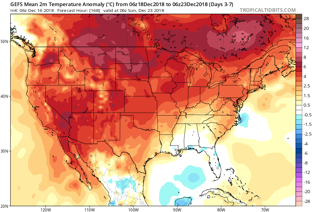
In the more immediate term, we note the latest GEFS showcases a classic “horse shoe” block that will favor a wintry regime across the east to open the new year- thanks to Tropicaltidbits.com.

You must be logged in to view this content. Click Here to become a member of IndyWX.com for full access. Already a member of IndyWx.com All-Access? Log-in here.
Late December through early January is a critical time period where most folks (even those maybe not normally interested in the weather) are glued in on the forecast. For some, they’re rooting for a white Christmas, while others are preparing for holiday travel to see loved ones. The idea here of a transitional pattern remains and this should promote active weather during the holidays this year.
Understanding things can change with respect to timing from this distance (in some cases 2+ weeks out), these are the dates we’re targeting for storm impacts across central Indiana:
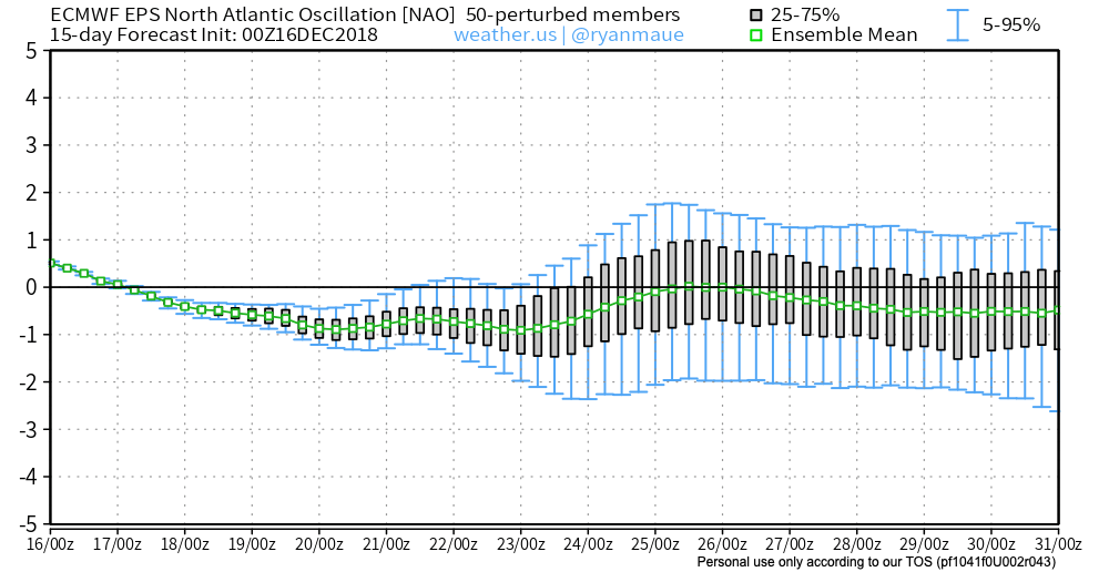
Before we talk specifics, it’s important to look at some of the pattern drivers. Some of these drivers include teleconnections such as the NAO, AO, PNA, and MJO.
Forecast indices with respect to the AO, NAO, and PNA are expected to be more or less neutral through the late month period. This is what the respective teleconnection “state” would result in the temperature department across the country.
Arctic Oscillation

North Atlantic Oscillation
Pacific North American Pattern

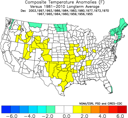
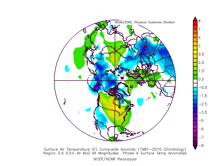
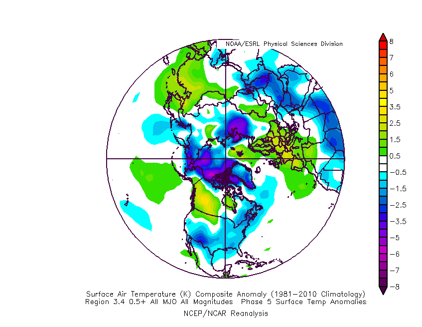
 The basis of our late-December forecast is built from the MJO, or Madden-Julian Oscillation. We note the MJO is expected to rumble through Phase 4 before heading into Phase 5 around Christmas. Phase 4 (image 2 below) is a warm phase and correlates well to what the week ahead will provide. However, Phase 5 (image 3 below) is a colder phase and could “up the ante” for the potential of wintry weather around Christmas.

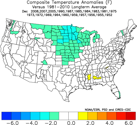
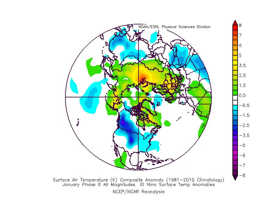
 If the MJO amplitude remains, it’ll roll into Phase 6 to close the month and open January. Here’s how that would correlate in the temperature department:
 The upcoming week will run milder than normal- lining up perfectly with MJO Phase 4.
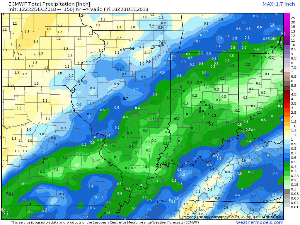
 The first of our targeted holiday storm systems will come at the tail end of the warm Phase 4 and will likely deliver a wind-whipped rain in here as early as Wednesday night and Thursday morning. However, as the storm pulls northeast along the Ohio River, it’ll deepen on its journey into the eastern Great Lakes region. This will help pull colder air into the region, likely resulting in rain transitioning to snow Friday. Given the path of the storm, this doesn’t favor some sort of prolonged backlash snow event, but it could be enough to result in accumulating snow across eastern Ohio Valley sections and downwind of the snow belt regions of northern IN, OH, and MI.
 The pattern, as a whole, appears to be one of transition to close the month and open January and it’s not really until we get to mid-January where we think all of the drivers “align” to create more of a lock and hold cold pattern. With that said, a stormy late December pattern can present problems, even in the midst of relatively mild times. We’ll be here to dissect the storms as they come throughout the holiday season…