Category: Long Range Discussion

Data Suggests Cold Pattern Keeps On Keepin’ On…

As we approach the all-important holiday travel season, I thought it would be nice to review what some of the data suggests in the long range sense.  While nothing is “set in stone” talking about weather 2-3 weeks out, we feel pretty confident in the overall idea of a colder than normal pattern and one that’s also potentially wintry- from a precipitation perspective.  The specifics with each storm will have to be handled as they come.

Let’s look at some of the data.  BTW, I want to give full credit to the awesome model suite that can be found at Weatherbell Analytics for some of these images.  Be sure to check them out at weather bell.com.

First, we’ll take a look at the Canadian ensembles, centered on the 8-16 day period.  Note the tongue of cold coming out of western Canada, extending southeast and encompassing the Ohio Valley region.  Folks, this is significant cold forecast off the Canadian ensembles as temperatures are suggested to average 5-7 degrees (C) below normal.

can_t2m_mean_conus_d8_16


The latest GFS ensembles also suggest widespread colder than normal temperatures over the upcoming couple weeks.  Similar to the Canadian (above), the GFS suggests temperatures average 5-7 degrees celsius below normal.

gefs_t2m_mean_noram_d0_16


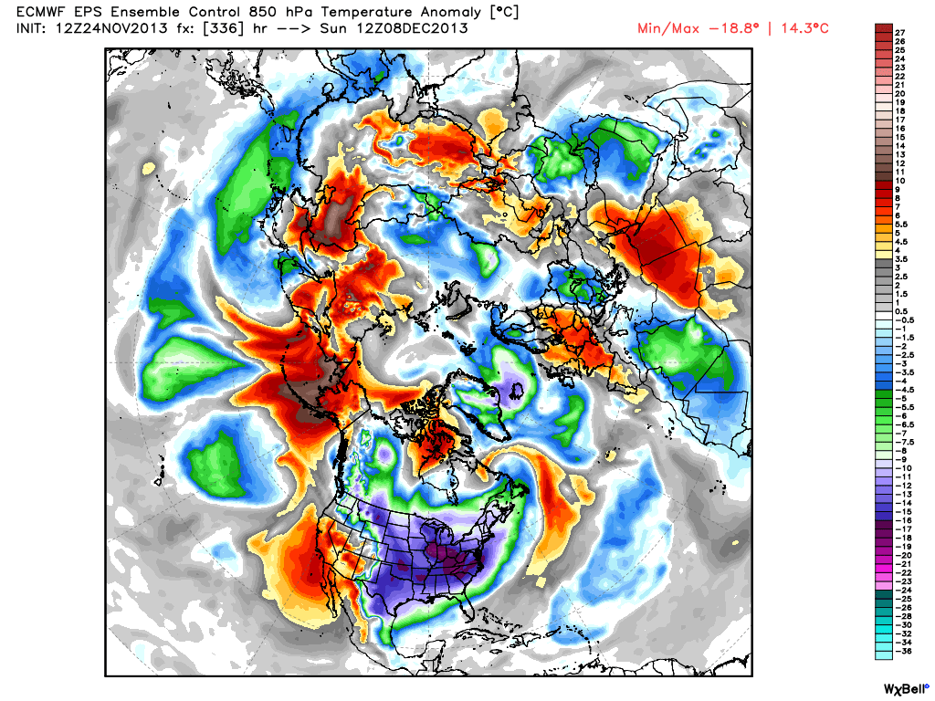
Latest European ensemble data suggests a cold look as well, but one that also may feature a day or two above normal (over the next couple weeks). The latest ensemble control run highlights the threat of some bitterly cold arctic air plunging south towards the second week of December (posted below).  We’ll continue to monitor this in the days to come.

eps_t850a_c_nh_57


Here’s a look at the latest CFSv2. While it’s in stark contrast to only a couple of weeks ago (in its December forecast), the model is now onboard with most other data in forecasting a colder than normal December for our region.

CFSv2.NaT2m.20131124.201312


It has to be pointed out that all of the cold data is forecast during a time where the three “major” teleconnections really aren’t in the most ideal spots for eastern cold.  Typically, cold lovers across the eastern United States want a negative AO and NAO with a positive PNA. The NAO and AO are forecast to be very “sporadic” over the course of the upcoming 7-10 days while the PNA is forecast to go back negative.  That said, the NAO has the biggest influence on our weather from January through March (we’ve covered this in posts in the archives).  The expansive early season snow and ice pack through western Canada is having it’s say with a couple of early season “brutal” cold shots here (it’s very rare to get this kind of cold so early in the season).  We’ll continue to monitor these teleconnections moving forward for any sort of a more defined signal that may begin to come to fruition.

Speaking of snow and ice cover; look at how much more territory across the Lower 48 is covered with snow and ice compared to this date (November 24th) last year.  Impressive, huh?

November 24, 2012 (11.8% covered in snow)

nsm_depth_2012112405_National

November 24, 2013 (37.8% covered in snow)

nsm_depth_2013112405_National

As we look closer at the near term, there’s a chance of some light snow moving in Monday evening (not a huge deal, but some light accumulations of a dusting to half an inch are possible).  Scattered snow showers will also blow into central Indiana Wednesday as a reinforcing shot of fresh arctic air blows in prior to Thanksgiving.

In the mid range, both the GFS and European ensembles (below) suggest an “intriguing” look for the first 10 days of December for the potential of a more widespread winter weather maker.  It’s far too early for details, but with arctic air being supplied into a pattern that looks to have a southern branch beginning to flex it’s muscle, we’ll have to remain on our toes as we go into December…  Here’s wishing you a very happy and healthy Thanksgiving, complete with safe travels!

Geopotential32at32500hPa_North32America_240gefs_z500anom_nh_65

Permanent link to this article: https://indywx.com/data-suggests-cold-pattern-keeps-on-keepin-on/

Thoughts On Winter…

This is the first time since 2002 that I haven’t produced a winter outlook.  Part of the reason behind this is due to the fact that our recent move back from Cleveland, OH to Indianapolis has taken priority.  Moving is always a much bigger chore than you expect originally.  That said, the upcoming winter of 2013-2014 presents quite the challenge when trying to determine what particular player takes control for the “long haul.”  I can’t remember a time when so many variables were at play, presenting quite the headache in trying to determine which one will take the lead.  Ultimately, confidence is lower than normal for the winter forecast.  That said, “confidence” in something 3-4 months out is never considered high. 🙂

Here are just a few items I’m looking at for the upcoming winter:

1. Data is pointing towards a southeast ridge in play for the better part of the upcoming winter.

The strength and precise position of the ridge will go a long way in aiding our weather here in central Indiana.  Southeast ridging isn’t always a bad thing in the winter if you’re a cold and snow fan as storms can’t “escape” harmlessly to our south or east.  That said, should we deal with a strong southeast ridge then we’re looking at a warmer, rainier time of things here as opposed to cold and snowy…

2. Modeling suggesting Nino Region 3.4 warms slightly as we progress through the winter months.

SST_table


The implications here are interesting when we drill down to the “home front.”  The following data from similar conditions during December-February in Nino Region 3.4 correlate to a few years that will go down in Hoosier snow lovers dreams…

Courtesy: http://www.cpc.ncep.noaa.gov/products/analysis_monitoring/ensostuff/ensoyears.shtml
  • 1977-1978: 49.7″ of snow, 2nd snowiest winter on record; Nino Region 3.4: +0.8
  • 2002-2003: 46.9″ of snow, 4th snowiest winter on record; Nino Region 3.4: +1.2
  • 2009-2010: 32.2″ of snow, 10th snowiest winter on record; Nino Region 3.4: +1.6

3. NAO showing signs of going negative when it matters most?

Labeled as the new “NAO Model everyone is looking for” may, perhaps, be just that.  This formula has already proven to be incredibly accurate in the past.  This was developed by fellow midwestern, Al Marinaro (you can follow him on Twitter at @wxmidwest).  In the past I’ve been one to say it’s incredibly difficult to forecast the NAO beyond 2-3 weeks, but we look at water temperatures this time of year to try and get an idea of what may happen in the coming winter months ahead.  If Mr. Marinaro is on to something (and it appears that he is) that longstanding idea will all change.

Additionally, to the delight of many cold and snow lovers out there, Mr. Marinaro’s formula suggests we’re heading for a predominantly negative NAO this winter.

BXihwRqCIAAtd3d.png-large


4. The normally “highly variable” CFSv2 (Climate Forecast System) monthly run has remained consistent as of late in thinking the east is warmer than normal for meteorological winter.  

It’s amazing how often this model is shown when forecasting cold, but seemingly forgotten when it’s forecasting warmer than normal conditions.

usT2mSeaInd2


Permanent link to this article: https://indywx.com/thoughts-on-winter/

Cold Close To October; Watching Halloween Closely…

Right on cue, the well advertised cold pattern is settling in and looks to remain entrenched over the region to close October and open November. Note the eastern trough and…

You must be logged in to view this content. Click Here to become a member of IndyWX.com for full access.  Already a member of IndyWx.com All-Access?  Log-in here.

Permanent link to this article: https://indywx.com/cold-close-to-october-watching-halloween-closely/

Change On The Horizon…

So far, October 2013 is running well above normal in the temperature department: As shown above, the lower lakes and Ohio valley region has been the target for the biggest…

You must be logged in to view this content. Click Here to become a member of IndyWX.com for full access.  Already a member of IndyWx.com All-Access?  Log-in here.

Permanent link to this article: https://indywx.com/change-on-the-horizon/

Sunday Afternoon Rambles…

Rain was plentiful over the region over the past 48 hours.  While widespread 2″ rainfall was common for all of central Indiana, the heaviest rainfall fell across southern and eastern Indiana.

Here are a couple of illustrations of the rainfall totals.  The first image is storm total rainfall from the past 24 hours. Note the heavy, 4″ type rains over southern and eastern Indiana. The second image is off the awesome Weatherbell model site and shows the heavy rainfall event over Indiana that unfolded on a bigger scale.  Needless to say, the short term drought concerns that we were dealing with August and September have been erased.

1379925_643932488960824_62568978_n


rtma_precip_48

Temperatures are running MUCH cooler over the region today and we also note a drier, more fall-like, air mass building into the region.  A couple of other items- it’s easy to see where the cold front is currently located (as of this post) as many in Ohio are still dealing with warm, humid conditions.  Additionally, the cold core upper level low remains to our west and will rotate over our region Monday.  This will lead to an unseasonably cool day with mostly cloudy skies and the potential of a scattered shower.

rtma_glus

As we move forward, despite the cooler air to welcome in the new work week, we remain in a warmer than average pattern overall.  The PNA continues to dominate the pattern and until this goes positive, don’t look for any sort of sustained cool weather across the eastern US.

gfs_pna_bias


The European operational and ensemble show the current trough and associated cool air retreating and allowing a warmer southwesterly air flow to build in this week.

Monday

Geopotential32at32500hPa_North32America_24


Thursday

Geopotential32at32500hPa_North32America_96After a quiet time ahead (and much needed to dry out), our next significant storm system appears to arrive around mid month.  Both the GFS and European model are in agreement with this idea.  Does another potential significant rain maker and associated severe weather event lie ahead mid month?  Possibly.

Here’s a look at the upper air pattern out at Day 10 off the European model.  We note another significant storm system ejecting out into the Plains states, most likely after dumping another impressive early autumn snow on the central and northern Rockies.

ecm_z500_anom_noram_11

The GFS idea is something similar to that of the European, suggesting confidence is relatively high, at least from this distance.

gfs_z500_sig_noram_37

All of that said, we’re still in a “transient” pattern as the next big storm is shown crashing onshore along the west coast by both models.  We shouldn’t be surprised by a “transient” pattern this time of year. It’s October, after all- a month notorious for many swings on the thermometer.

We’ll close with a look at the European’s temperatures anomalies over the course of the next 10 days.  Note the chill of early week erased with above normal warmth for the majority of the period. Also, pay attention to the unseasonable chill coming off the Rockies and into the Plains towards the end of the period below.  This is associated with the mid month storm.

tavg_anom_ecmwf_conus_1

Permanent link to this article: https://indywx.com/sunday-afternoon-rambles/