Category: La Nina

Something Doesn’t Jive…

I want to give a couple examples of significant conflicting signals- both short and long-term. The end result is a situation where long range, climate, and seasonal models are likely to have a very tough time not only in the medium to long range (2-4 week period), but thinking seasonally, as well (winter and next spring).

Short-term

To start, let’s look at the EPO. While strongly positive at present, both the EPS and GEFS pictured below take the EPO, or East Pacific Oscillation, negative in the coming couple of weeks.

A negative EPO pattern favors a trough across the eastern portion of the country, especially here in our neck of the woods, with western ridging.

All well and good, right? WRONG. The MJO, or Madden Julian Oscillation, is forecast to stall out into early October in Phase 1.

This time of year, Phase 1 argues strongly for eastern ridging and well above normal warmth while the western portion of the country can experience early wintry conditions.

Talk about contradiction! That’s what makes weather so fun and fascinating. Expect to be humbled often and to always learn! At various times of the year, select teleconnections can mean a lot more than other times of the year. For example, during the summer and fall, we lean heavily on the EPO, PNA, and MJO (if amplified). During the winter and spring, it’s important to take into account what the AO and NAO have to say. It’s important to know when to “pick and choose” when to use particular teleconnections… Furthermore, the various MJO phases (1-8) mean drastically different things at different times of the year. While lovers of chilly fall conditions have grown to hate an amplified Phase 1, they have to love it come winter (shown below). Just look at that difference!

Before jumping ahead to another example of “contradicting signals,” we’re confident the amplified MJO Phase 1 will carry the day through the short to medium range period. Note the strong agreement between the EPS and GEFS below with respect to temperature anomalies in the 6-10 day period.

With that said, there will be challenges within (the big difference as early as this weekend between the GFS and European operational data). A lot of that has to do with the “fight” between the EPO and MJO to take control.

As all of this unfolds across the East, the west will begin to cash in on early winter. Well below average cold and snowy conditions will begin to make headlines over the weekend into next week across not only the Rockies, but some of the low ground, as well. Should the MJO swing into Phase 2 (and I think it will towards mid-Oct), then watch out. We’ll be looking at a rather significant shift towards a much colder feel- and it’ll sting even more so with the late season heat over the better part of the next couple of weeks.

Flipping the page to winter (remember, our prelim. winter outlook will be posted later this week) and the contradiction continues. Upon looking at the current SST configuration, one could easily argue we’re talking about a La Nina winter unfolding ahead.

Meanwhile, the current SOI would suggest we’re in a moderate El Nino.

If you think this can’t wreck havoc even on the short-term forecast pattern, think again…

To close, while the conflicting data can create headaches at times, it’s more fascinating than ever trying to sift through the data and build our forecast(s). It’d be wise to expect more wild swings ahead- leave it to us to try and minimize the impacts of those swings in your day-to-day personal and professional lives. Accordingly, it’s also ultra-important to factor in additional items, such as solar and PDO into the equation for the upcoming winter.

Speaking of, without giving too much away, if I’m a winter weather fan (and I am), I wouldn’t worry in the least about the current warmth… 😉

Permanent link to this article: https://indywx.com/2019/09/23/something-doesnt-jive/

Trying to Answer Questions When Winter Will Show Up…

Daily, we’re receiving questions around if and when winter will show up. While admittedly later than originally thought here, we’ve never been in the camp of “throwing the towel” in on winter. Our winter outlook that includes below normal cold and near average snowfall remains unchanged.

Before we get into some of our reasons why we think winter will show up (and likely make up for lost time), the upcoming week will remain much warmer than average.

We’re tracking (3) storm systems that will deal the region rain over the upcoming week:

  1. Southern IN this afternoon and evening
  2. All of the state Monday
  3. All of the state next Friday into Saturday

As a whole, rainfall amounts won’t be particularly impressive for most, with 7-day totals between 0.25″ to 0.75″ for central portions of the state. Heavier amounts can be expected across southern areas.

Now, let’s look ahead to some potentially colder times. Before moving forward, it’s important that we recognize models have attempted once already to drive in a wholesale pattern change to colder (originally thought to be underway now). Perhaps it’s a case of “delayed, but not denied.” There’s a lot going on behind the scenes:

  • Sudden stratospheric warming event and potential polar vortex displacement, etc.
  • SOI flipping from a Niña-like state to one we’d expect to see associated with an El Niño
  • Active MJO remains

There are significant changes brewing in the arctic/ higher latitudes that have to raise an eyebrow at the very least.

Today

Mid-January

Note the higher pressures building over the upcoming 10-14 days in the arctic regions.

Not surprisingly, the models begin to tank the AO.

The PNA rises…

Something that also lends credence to a potential pattern shift is the recent SOI drop.

This would tend to suggest that an active storm track may be in place as the more bonafide cold shift is underway.

The moral of the story? Despite the milder period being extended a couple weeks longer than originally thought, there’s still a lot on the table this winter. It’s far too early to think winter’s over before it’s really even begun for most. We expect to see increasingly wintry conditions show up around the middle of January…

Stay tuned.

Permanent link to this article: https://indywx.com/2019/01/04/trying-to-answer-questions-when-winter-will-show-up/

A Word (Or Two) On Where We Think This Pattern Is Going…

Before we get into the updated thinking on the pattern, lets review what we have out:

  • Step-down process to cooler/ colder weather begins in mid-November.
  • Thanksgiving-Christmas period, as a whole, turns wintry and is snowier than average.
  • Our complete 2016-2017 Winter Outlook can be found here.

The first week of November has featured an incredibly warm start to the month. (Image courtesy of MRCC).

month-tdevSpeaking of warmth, 2016 has been a very warm year.

ncep_cfsr_t2m_anom_ytd(The cold of 2014 seems so long ago…)

ncep_cfsr_t2m_anom_2014Back to present.  We’ve targeted the middle part of November to finally beginning “bucking” the recent warm trend.  This won’t happen overnight and will be a battle of back and forth, initially.  Thus, the “step-down” label.  To be clear, November, as a whole, will finish much warmer than average.  It’s virtually impossible to counter the incredibly warm start.  That said, we do anticipate “jabs” of colder air working in here over the next couple weeks. For instance, this weekend will feature lows in the 20s for most and highs not making it out of the 40s Saturday afternoon.  (The average low and high at IND Saturday are 37 and 54).

Despite being in a weak La Nina, the pattern is taking a while to respond.  Remember, we’re coming off one of the strongest El Ninos on record.  Until we slow the PAC jet, significant, long-lasting, changes won’t occur.  We can lean on the AAM (Atmospheric Angular Momentum) forecast for clues as to when this may occur.  You can read more about the AAM here.  My fellow local weather compadres, Michael Clark, Ed Valley, and Kirk Hinz have also written/ blogged extensively about the AAM and resulting impacts.

gfsgwo_1

gfs1When we look at the AAM forecast (above), we note the westerlies may begin to slow (indicative of the negative values) in the 8-10 day period.  This is crucial and, simply put, has to happen for the pattern to begin shifting into more of a position to allow sustained cold to enter the equation.  We want to reiterate that this, in and of itself, doesn’t create the cold, but instead allows the pattern to begin shifting away from the Nino-like (warm) regime into more of a La Nina pattern, as a whole.  – Hey, you have to start somewhere.

If we can finally get the westerlies to slow, other elements are in play that could (and should) lead to a colder pattern as we move forward.  Our (3) big teleconnections are in a position favorable for cold for mid/ late November, into early Dec.

cw5yrrsxaaefhiy-jpg-largeAdditionally, the EPO is forecast negative off the GEFS and EPS. (Images courtesy of Weatherbell.com).

eps_epo_bias

gefs_epo_12Again, this is a cold signal. (Image courtesy of Madusweather.com).

eponew_neg_11novThe ensemble data is also beginning to key-in on higher heights (blocking) developing over the top.  Notice the significant changes in the overall look to the pattern between now and days 11-16. (Images courtesy of Weatherbell.com).

cw5qrw0wgaaphxr-jpg-largeIn summary, and in the face of *most* seasonal data that is screaming warm, warm, warm, we still don’t have any significant changes to our overall thinking of “step-down” mid-November giving way to more sustained wintry-like conditions in the overall sense from the Thanksgiving-Christmas period.  Time will tell and only the Good Lord knows what the future holds, but we’ve done far too much work and research to throw the “game plan” in the trash before the game even begins…

Permanent link to this article: https://indywx.com/2016/11/10/a-word-or-two-on-where-we-think-this-pattern-is-going/

Winter Ideas…

We continue to finalize our winter forecast, which will be posted, as always, here later this month.

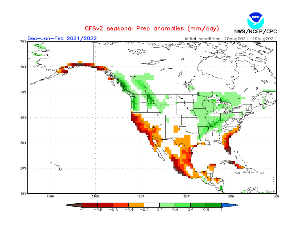
As little as only a few months ago, data suggested a major La Nina for the upcoming winter season.  That data has since backed off significantly.  In fact, some runs suggest we’re back into a weak-ish El Nino state by spring.  At the very least, we are confident on avoiding a strong La Nina this winter and lean more in the direction of a weak Nina, at best, to neutral signal.  The CFSv2 is interesting, as always, with the spread in region 3.4.

nino34monadj

sstanimIn addition to the central PAC anomalies, we also are keying in on some other items of interest in the overall SST configuration:

I. Warmth in the GOA (Gulf of Alaska)

Argues for central cold this winter, spreading east with time.

II. Warmth off the eastern seaboard

Will likely serve to limit the ability for the cold to spread east early on in the season

92916sstThe SST CA model is quickly becoming one of our more trusted seasonal forecast models.  We note how it becomes increasingly bullish on a central and eastern trough as winter wears on (by the way, this is likely to go deep into spring this year, too).

screen-shot-2016-10-02-at-10-52-54-am

screen-shot-2016-10-02-at-10-53-04-amCold overwhelms the pattern and when you combine it with the active storm track (noted by the green hues, suggesting above normal precipitation through our neck of the woods), confidence is continuing to grow for an above normal snow season.

screen-shot-2016-10-02-at-10-58-16-am

screen-shot-2016-10-02-at-10-58-05-amThe SST configuration on the JAMSTEC would suggest a cold, stormy set-up, locally.  That said, while it sees the above average precipitation, it’s awfully warm at the surface.

ssta-glob-djf2017-1sep2016

tprep-glob-djf2017-1sep2016

temp2-glob-djf2017-1sep2016The NMME (to no surprise…) would suggest a very warm, wet winter.

screen-shot-2016-10-02-at-11-08-26-am

screen-shot-2016-10-02-at-11-09-00-am

screen-shot-2016-10-02-at-11-08-47-amAs a reminder, our complete and final annual winter outlook will be posted here during the second half of October.  That will include additional model data, along with several other points behind our reasoning for our winter forecast.  As we always do, we’ll put “pen to paper” when it comes to our winter forecast, including our expected temperature and snowfall anomalies.  Given the data above, including the warm JAMSTEC and NMME, it’s going to be very, very hard to see a warm winter here.  In fact, our idea is for the exact opposite, given the SST configuration, and lines up more closely with the SST CA idea at this point.  We’re also in the camp of a very, very active storm track through the Ohio Valley.  “Big-hitter” potential is present from a winter storm perspective, especially given that we are likely to see resistance from the SE ridge.

Much more later this month…

Permanent link to this article: https://indywx.com/2016/10/02/winter-ideas/

Protected: Fresh Summer Thoughts…

This content is password protected. To view it please enter your password below: Password:

You must be logged in to view this content. Click Here to become a member of IndyWX.com for full access.  Already a member of IndyWx.com All-Access?  Log-in here.

Permanent link to this article: https://indywx.com/2016/04/21/fresh-summer-thoughts/

Protected: Client Update: Summer Thoughts And Video Update On Severe…

This content is password protected. To view it please enter your password below: Password:

You must be logged in to view this content. Click Here to become a member of IndyWX.com for full access.  Already a member of IndyWx.com All-Access?  Log-in here.

Permanent link to this article: https://indywx.com/2016/03/15/client-update-summer-thoughts-and-video-update-on-severe/

Saturday Morning Rambles…

1.) An absolutely stunning late February day is dialed up, with lots of sunshine and moderating temperatures.  We’re going mid 50s this afternoon.

1

2.) Though warm (lower 60s), Sunday will offer up showers by the afternoon/ evening.

2

3.) Mid and late week remains a challenge.  Do we have a leader-follower situation?  Time will tell.  We’re still leaning mostly wet for the Tuesday-Wednesday storm for now.  The late week system could offer up accumulating snow prospects (ala. ECMWF, GEM).

3

4

4.)  The period opens warm, but we shift much colder than average by the end of the week.

5 6

5.) We continue to look into spring and summer.  With the dramatic shift expected to a La Nina, fun times will ensue.  Hot, dry summer around these parts followed by a snowy winter?  Hmmmm….

7

Interested in our private consulting services?  E-mail bill@indywx.com for more information.

Permanent link to this article: https://indywx.com/2016/02/27/saturday-morning-rambles-7/

IndyWx.com