You must be logged in to view this content. Click Here to become a member of IndyWX.com for full access. Already a member of IndyWx.com All-Access? Log-in here.
Category: Heavy Rain
Permanent link to this article: https://indywx.com/2020/06/23/video-turning-less-humid-more-on-weekend-storms-and-the-early-july-pattern/
Jun 22
VIDEO: Week-Ahead Outlook; Storms Followed By Less Humid Air Into Midweek…
You must be logged in to view this content. Click Here to become a member of IndyWX.com for full access. Already a member of IndyWx.com All-Access? Log-in here.
Permanent link to this article: https://indywx.com/2020/06/22/video-week-ahead-outlook-storms-followed-by-less-humid-air-into-midweek/
Jun 12
Long Range Update: Timing Out When The Dry Pattern Breaks Down; 2nd Half Of Summer Chatter…
The balance of the upcoming 7-10 days will feature bone dry conditions across central Indiana. A fast moving disturbance will drop southeast Saturday and could spawn a scattered shower across central Indiana, but we believe the more concentrated rain activity will remain to our east and southwest. If you do see a Saturday shower, count yourself lucky! This disturbance and associated cold front will serve to reinforce the dry airmass currently in place, along with bring temperatures down another couple of “notches” for the weekend (wouldn’t be surprised if some outlying areas get into the 40s Sunday or Monday mornings).
As we look ahead, a ridge of high pressure will dominate next week’s weather pattern. An extended stretch of dry (pleasant humidity levels), sunny days can be expected with a slow warming trend.

Things begin to get a little more “murky” late next week as forecast model solutions differ significantly. The new GFS forecast model drives a cold front into the Ohio Valley before stalling out as multiple disturbances ride along the boundary. This would lead to needed rain (and potentially heavy rain at that) late next week into next weekend. Meanwhile, the European model isn’t nearly as excited about this wet weather potential. The reality likely lies somewhere in between and we’ll trend our forecast wetter late week, but hold on the heavy rain threat for now. Stay tuned.
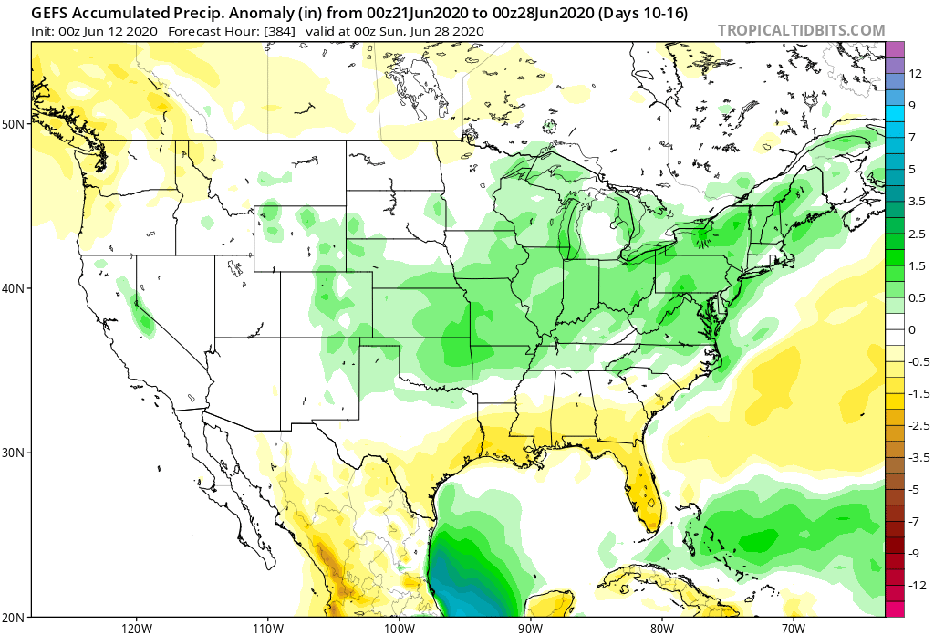
With that said, we do believe (given the pattern drivers discussed below) that the wetter trends shown on the GFS ensemble data in the Week 2 (and beyond) time frame has validity.

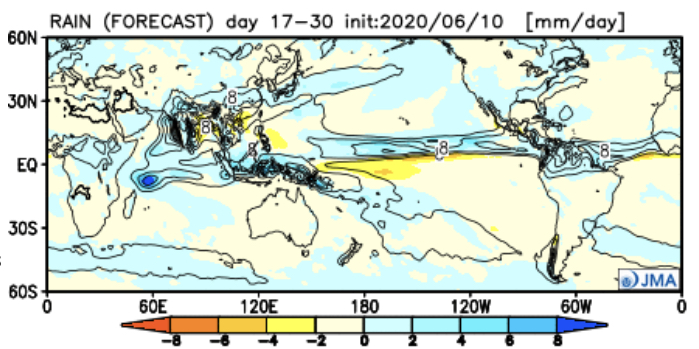
The latest JMA Weekly data also shows a similar wet idea during this time period.

As we look at the PNA and EPO, the transition in both teleconnections next week do give credence to the wetter them shown above during the said period.
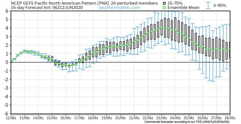
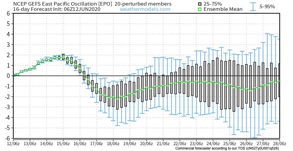
Additionally, the positive PNA (image 1 above) and negative EPO (image 2 above) argue for the possibility of another period of cool weather to wrap up the month. This would come after transitional heat late next week.
The GEFS is cooler than the European during this time frame. Given the above, it wouldn’t surprise us if the Euro is forced to cool as we get closer to this period.
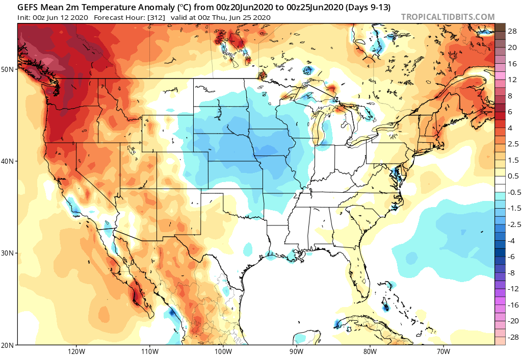
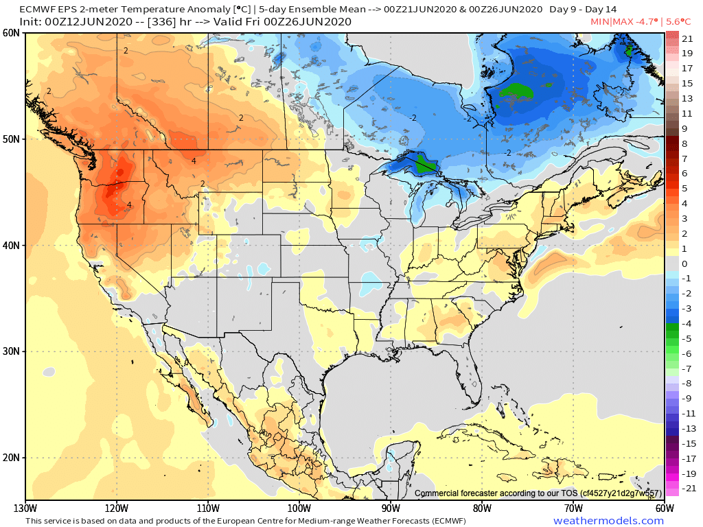
We’re undoubtedly entering into a critical time frame for the remainder of the summer. The upcoming couple of weeks will go a long way in determining the balance of the rest of this season. Despite the short-term dry pattern, we do believe (at least locally), rain will return before things get out of hand. The same may not be able to be said just to our west. It’s there (more from the Rockies into the Plains) where we think July heat will build in more significant fashion with the drier soils.
Permanent link to this article: https://indywx.com/2020/06/12/long-range-update-timing-out-when-the-dry-pattern-breaks-down-2nd-half-of-summer-chatter/
Jun 08
Gorgeous Open To The Work Week Gives Way To Cristobal Remnants Tuesday…
You must be logged in to view this content. Click Here to become a member of IndyWX.com for full access. Already a member of IndyWx.com All-Access? Log-in here.
Permanent link to this article: https://indywx.com/2020/06/08/gorgeous-open-to-the-work-week-gives-way-to-cristobal-remnants-tuesday/
Jun 05
VIDEO: Turning Less Humid This Weekend; More On Remnant Tropical Moisture And A Cool Mid-June…
You must be logged in to view this content. Click Here to become a member of IndyWX.com for full access. Already a member of IndyWx.com All-Access? Log-in here.
Permanent link to this article: https://indywx.com/2020/06/05/video-turning-less-humid-this-weekend-more-on-remnant-tropical-moisture-and-a-cool-mid-june/
Jun 04
VIDEO: How Cristobal May Indirectly Influence Our Weather Next Week; Cooler Pattern Builds In For Mid-Month…
You must be logged in to view this content. Click Here to become a member of IndyWX.com for full access. Already a member of IndyWx.com All-Access? Log-in here.
Permanent link to this article: https://indywx.com/2020/06/04/video-how-cristobal-may-indirectly-influence-our-weather-next-week-cooler-pattern-builds-in-for-mid-month/
May 18
VIDEO: Cut Off Upper Low And Late-May Thoughts…
You must be logged in to view this content. Click Here to become a member of IndyWX.com for full access. Already a member of IndyWx.com All-Access? Log-in here.
Permanent link to this article: https://indywx.com/2020/05/18/video-cut-off-upper-low-and-late-may-thoughts/
May 17
VIDEO: Discussing The Severe/ Localized Flooding Threat Tonight And Looking Ahead To The Holiday Weekend…
You must be logged in to view this content. Click Here to become a member of IndyWX.com for full access. Already a member of IndyWx.com All-Access? Log-in here.
Permanent link to this article: https://indywx.com/2020/05/17/video-discussing-the-severe-localized-flooding-threat-tonight-and-looking-ahead-to-the-holiday-weekend/
May 17
Risk Of Rotating Storms This Evening-Tonight…
Quick short-term update this morning to discuss the potential of severe weather later this evening and into the nighttime hours. (We’ll have a more in-depth video update posted this evening, including longer range thoughts).
This morning has featured a few rain showers scattered about central Indiana, but the heavier, more organized, rain from the overnight is long gone (for now). While showers will impact central Indiana at times into the early afternoon hours, it’s not until late evening and the nighttime hours that we anticipate more organized shower and thunderstorm activity. Given the ingredients in place, there’s the potential of a few rotating storms tonight and subsequent risk of tornadoes. Sunshine, or not, it’ll be important to remain weather-aware tonight and have a means of getting the latest warnings that may be issued. Should we see a period of sunshine later this afternoon, the threat of severe weather will be elevated tonight.
The Storm Prediction Center (SPC) includes central and western portions of the state in a Slight Risk of severe weather in their most recent Day 1 Outlook.

The window of severe weather potential appears to come after 8p for central Indiana, continuing into the overnight hours.

Locally heavy rain will shift from western Indiana (tonight) into the eastern half of the state (Monday). Widespread 1″ to 2″ of additional rain is likely.

As the upper low “cuts off” early-mid week, shower chances will continue along with cooler temperatures.
Make it a great Sunday! Chat with y’all a bit later today!
Permanent link to this article: https://indywx.com/2020/05/17/risk-of-rotating-storms-this-evening-tonight/
May 01
Welcome To May: Threat Of Record Cold Week 2…
A gorgeous Friday is dialed up complete with plentiful sunshine and temperatures warming quickly from the mid and upper 30s into the mid and upper 60s.
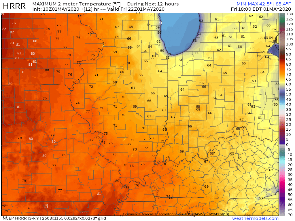
A couple weak impulses of energy will scoot through the Ohio Valley over the next 24 hours and while they will spark a few showers/ embedded thunder predawn Saturday and again Saturday night, most of the daytime hours Saturday will also feature dry conditions.
That begins to change Sunday as widespread showers and thunderstorms are expected to rumble across central Indiana, especially during the morning hours. Locally heavy downpours are likely.
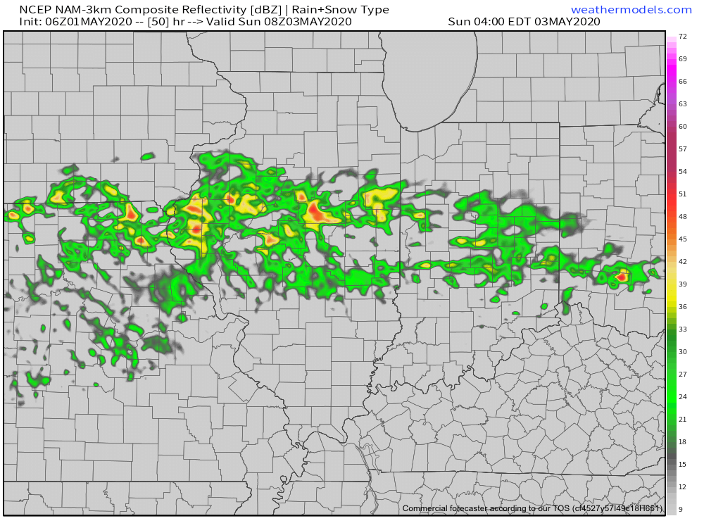
A quick 1”-1.25” is a good bet across the heart of the state with this system Sunday morning.
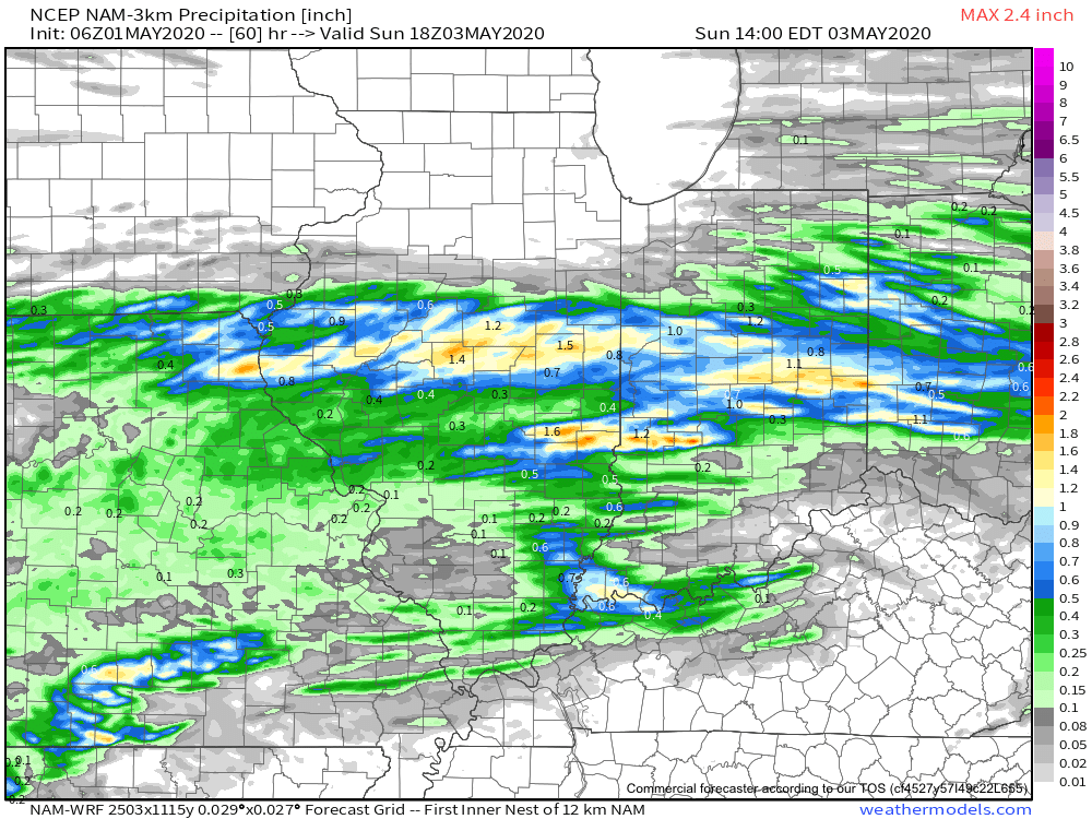
Dry conditions will quickly return Sunday evening into Monday thanks to high pressure briefly building back into the region. This will lead to a pleasant open to the work week with highs topping out in the middle 60s.
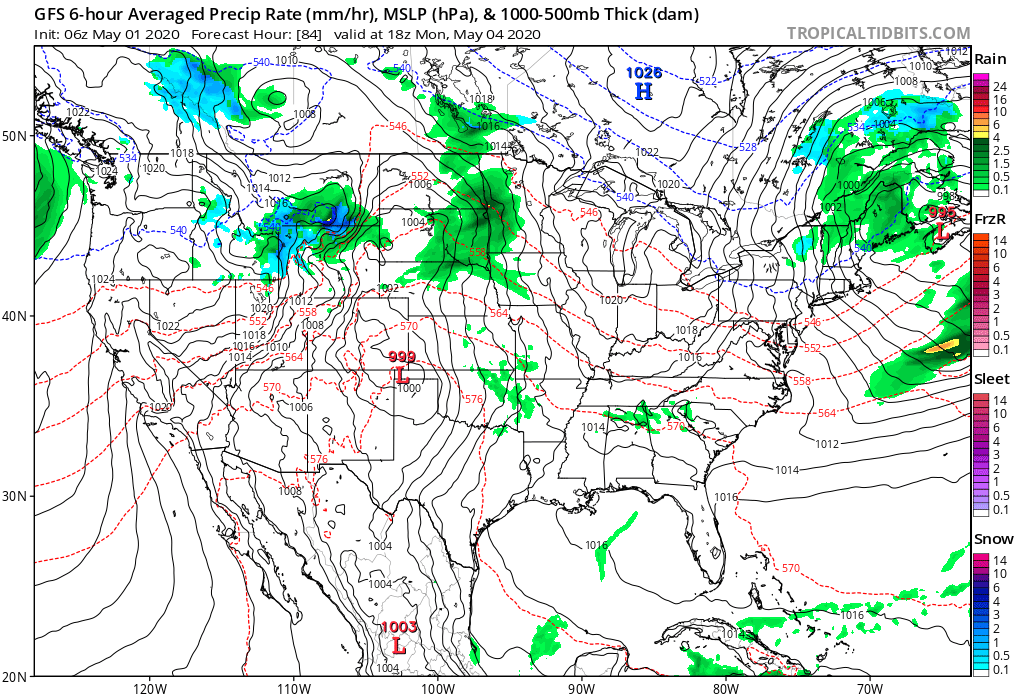
Unsettled weather returns as early as Tuesday with increased chances of showers and thunderstorms ahead of a strong cold front.

Though we’ll certainly turn cooler for the middle to latter part of the week, this will only be a precursor to what lies ahead behind yet another strong cold front late next week.
The air will likely challenge records into the Week 2 time frame (May 8th-14th), including the threat and increased likelihood of late season frost/ freezes. We also likely haven’t seen the last of the snow flakes for the season either…
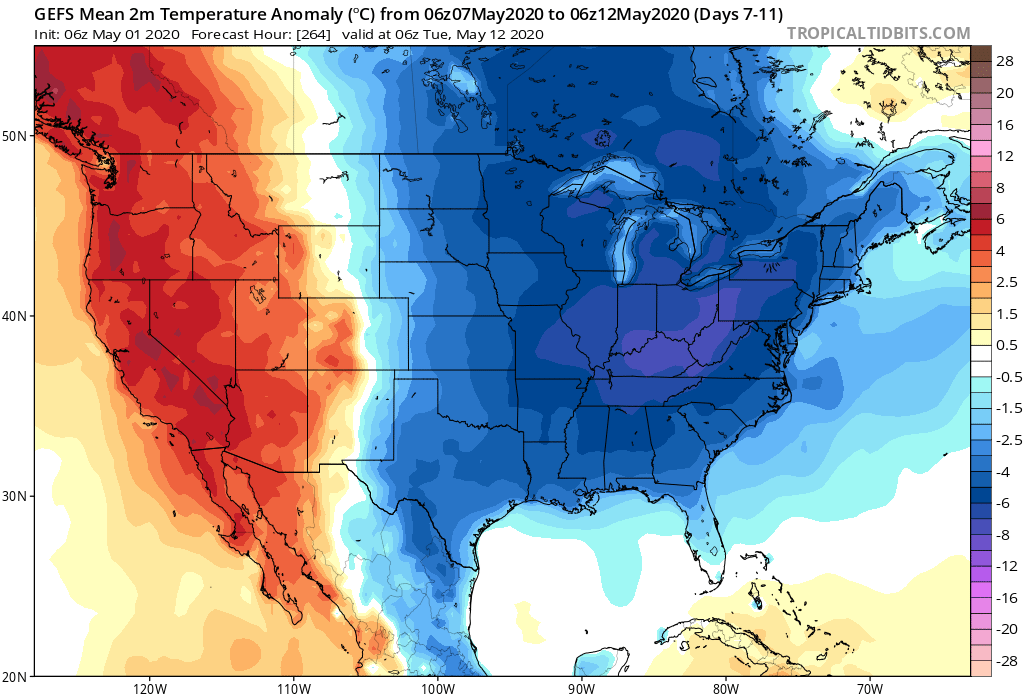
Permanent link to this article: https://indywx.com/2020/05/01/welcome-to-may-threat-of-record-cold-week-2/
