Updated 05.03.24 @ 7:40a Scattered showers will continue to push out of the area this morning and we should get back to plenty of dry time this afternoon. While we…
You must be logged in to view this content. Click Here to become a member of IndyWX.com for full access. Already a member of IndyWx.com All-Access? Log-in here.
A very pleasant day is in store for the region, complete with plenty of sunshine. Enjoy as we’re heading into yet another unsettled and wet pattern over the weekend and into the new week ahead…
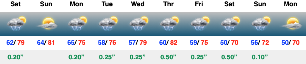
At one time what appeared to be a window of drier weather moving in now looks to be filled with active and at times stormy conditions as we navigate the first week to 10 days of May. Initially, rain totals won’t be “uniform” and scattered in nature but by the time all is said and done by the end of the first week of May, many can expect 2″+. The scattered coverage, locally, today will likely congeal into a more widespread complex of rain/ storms just to the north and northwest of the city later this evening.
This morning’s video covers those wetter trends in more detail…
It was a frosty start to the morning across central Indiana, especially in outlying areas. We’ll do it all over again tonight and Monday morning as temperatures dip back into the lower and middle 30s. The fine folks over at the Indianapolis National Weather Service office have hoisted a Frost Advisory from 1a to 10a Monday.
Widespread frost is expected Monday morning.
Otherwise, the work week will open with a continuation of the sunny skies we’ve enjoyed over the past few days.
That will all begin to change as a cold front arrives from the northwest on Tuesday. Clouds will quickly return and showers and thunderstorms will follow. We’re not talking about excessive rainfall with this system, but 0.25″ to 0.50″ is likely as the front moves through the Ohio Valley. Gusty southwesterly winds can also be expected, including up to 40 MPH at times Tuesday.
Rain and embedded thunder returns Tuesday.
This will be a fast moving system and dry conditions will quickly return overnight and into Wednesday morning. This FROPA we’ll also help to reinforce the chilly airmass and a renewed frost (and potentially even a freeze) threat looms by Wednesday and Thursday mornings.
Another round of frost is expected midweek.
As we roll into next weekend, an overall regime change is on the docket, including a much warmer and more humid airmass engulfing the region. Along with this transition to more of a tropical feel, heavier rain and storms will return as well. As of now, closing out April and opening May is looking to feature numerous heavier rain and storm events. This will all get kicked off Friday.
A return of active times is expected to close April and open May.
Updated 04.10.24 @ 7:40a We’re only dealing with a few light showers out the door this morning, but a heavier and more widespread area of rain will develop through the…
You must be logged in to view this content. Click Here to become a member of IndyWX.com for full access. Already a member of IndyWx.com All-Access? Log-in here.