Category: Heavy Rain
|
Wed.
|
Thr.
|
Fri.
|
Sat.
|
Sun.
|
Mon.
|
Tue.
|
|

|
|

|
|
|
|
|
|
64/ 74
|
60/ 79
|
60/ 73
|
51/ 75
|
59/ 83
|
70/ 84
|
71/ 88
|
|
Light
|
Light
|
– – –
|
– – –
|
– – –
|
Moderate
|
Moderate
|
The big ole’ area of low pressure that we’ve been talking about now for a few days will continue to influence our weather today. It certainly won’t rain the entire time and we may even see some sunshine at times today. That said, locally heavy down pours in scattered rain bands can be expected yet again. Drier air will slowly move in Thursday, but a cold front will blow through the area Thursday night into Friday morning and a thunderstorm is possible as this front blows across the region. A much drier, cooler air mass will move in behind this boundary and set up a pleasant time of things Friday and Saturday. As we move into another new week temperatures will warm dramatically and the hottest weather of the season will be accompanied by unsettled weather Monday and Tuesday.
Permanent link to this article: https://indywx.com/unsettled-wednesday/
-
Filed under 7-Day Outlook, Canadian Model, Forecast, Forecast Discussion, Forecast Models, GFS, Heavy Rain, HRRR, Long Range Discussion, NAM Model, Rain, Short term update, T-storms, Unseasonably Cool Weather, Unseasonably Warm, Weather Videos
-
June 10, 2014
Good evening and thank you for logging onto IndyWx.com! Tonight’s video covers the unsettled time of things tonight into Wednesday morning as low pressure continues to have a hold on our area’s weather. Also, we talk long range weather and give you an idea of what you can expect for the rest of the month of June, temperature-wise! While we didn’t get into the precipitation side of things in tonight’s video for late month, I will say it continues to look very unsettled with above average rainfall anticipated to wrap up the month of June. Anywhere from an additional 3-5″ of rain is possible as we go through the rest of the month here across central Indiana.

While the CFSv2 can be a bit erratic at times, we feel the model has a good handle on the way the overall pattern will evolve late June into July.
Permanent link to this article: https://indywx.com/tuesday-evening-video-update/
Widespread light to moderate rain moved into central Indiana during the predawn hours. Most communities picked up .20″-.30″ since midnight. Some of asked if this is it for the rain today? Unfortunately not. The large low pressure system that’s sitting and spinning to our southwest will continue to pump copious amounts of moisture north through the afternoon and into Wednesday. Heavy showers and embedded thunderstorms (non-severe) will redevelop this afternoon and evening and be responsible for locally heavy rainfall.
Forecast radar through the afternoon and heading into the evening hours.
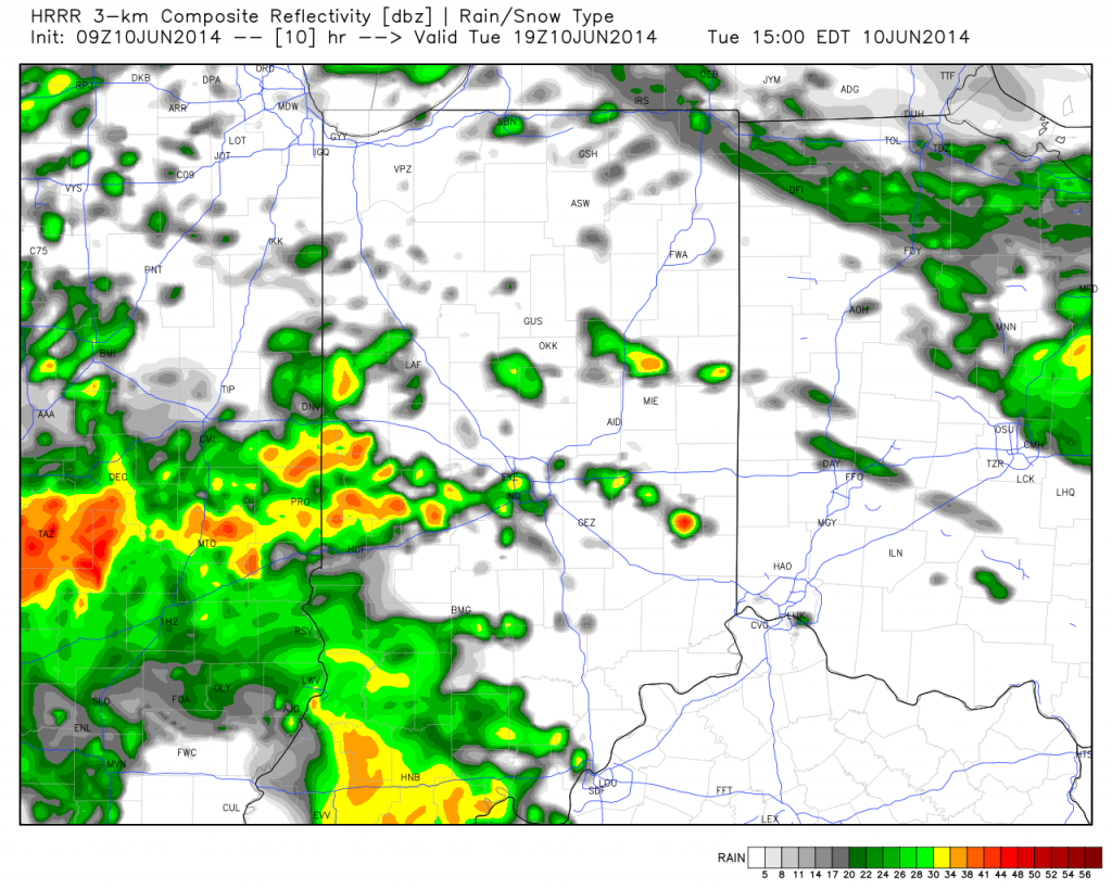
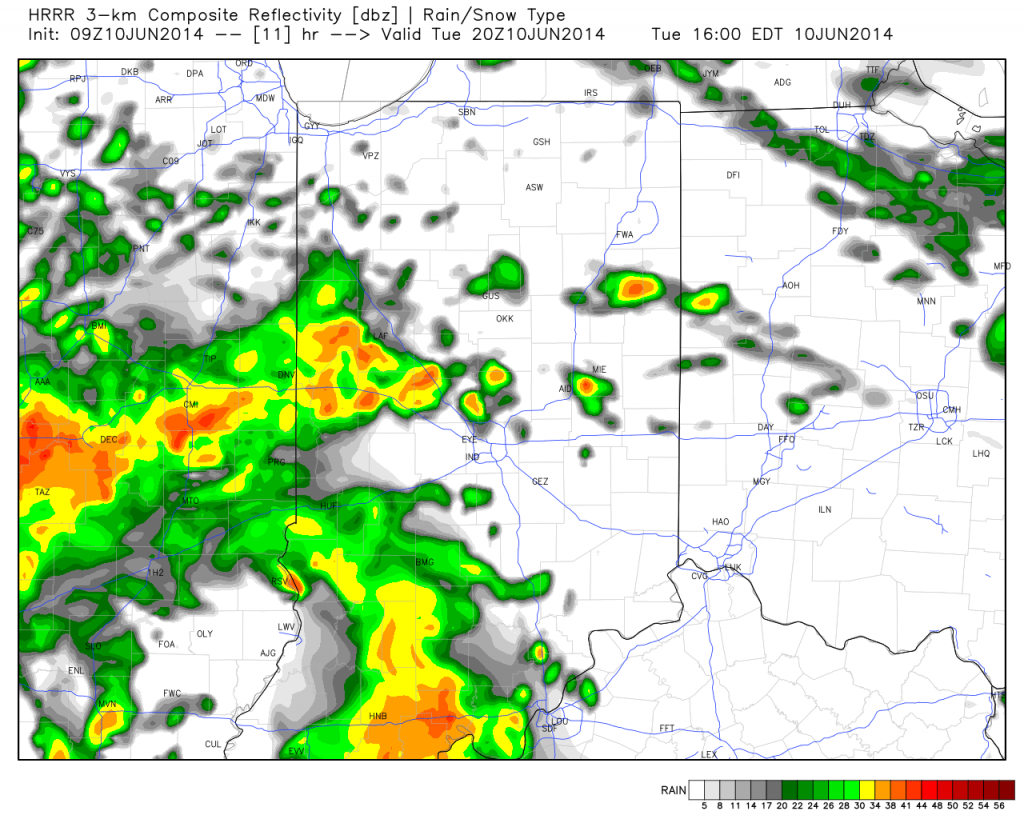
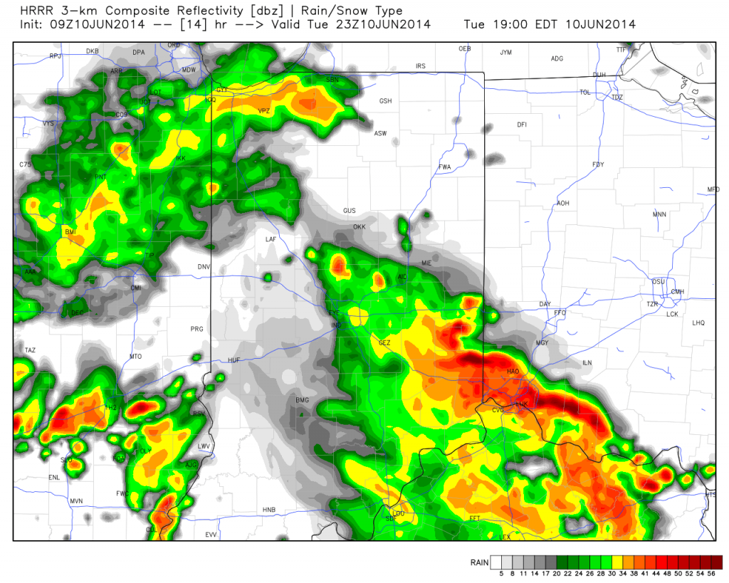
We still anticipate widespread rainfall totals of 1-2″ across central Indiana when you look at the 48 hour period- 12a Tuesday through 12a Thursday.
Grab a good book and settle in for a wet day!
Permanent link to this article: https://indywx.com/wet-day-ahead/
|
Tue.
|
Wed.
|
Thr.
|
Fri.
|
Sat.
|
Sun.
|
Mon.
|
|

|
|
|
|
|
|
|
|
62/ 71
|
64/ 76
|
58/ 78
|
63/ 73
|
52/ 75
|
56/ 86
|
66/ 87
|
|
Moderate
|
Light
|
Light
|
Light
|
– – –
|
– – –
|
Light
|
A slow moving, swirling, area of low pressure will impact the central Indiana region over the course of the next couple days. This spells a more humid time of things with a deep southerly flow in place, but with all of the clouds around, expect temperatures to average below normal Tuesday and Wednesday. We’re looking at steady rains pushing northeast early Tuesday morning and sticking around for the better part of the day, including periodically heavy down pours. Rain will begin to scatter in coverage Wednesday, but the better part of the day will be wet, with continued embedded heavy rain. We continue to think widespread rainfall totals of 1-2″ is a good bet over the course of the upcoming 48 hours. Drier air will slowly begin to invade Thursday, but we can’t completely shake the shower chance. Finally, as we get set to close out the work week, a cold front will move through the area. A shower or thunderstorm is possible Friday as the front slides through, but the bigger deal will be the punch of drier, cooler air behind the boundary. This will set the stage for yet another ideal Saturday, weather-wise! Warmth and humidity will build late in the weekend and continue into the first part of next week.
Permanent link to this article: https://indywx.com/soaking-rain-tuesday/
Sun. Mon. Tue. Wed. Thr. Fri. Sat. 59/ 75 55/ 77 62/ 75 66/ 76 66/ 77 61/ 75 55/ 78 Light –…
You must be logged in to view this content. Click Here to become a member of IndyWX.com for full access. Already a member of IndyWx.com All-Access? Log-in here.
Permanent link to this article: https://indywx.com/unsettled-stretch-ahead/


